
Life-threatening and potentially catastrophic flash flooding and mudslides forecast for Honduras’ northern coast
The northern coast of Honduras is bracing for life-threatening and potentially catastrophic flash flooding and mudslides as Tropical Depression Nineteen (TD19) moves westward, with up to 760 mm (30 inches) of rainfall anticipated, before the storm shifts toward Belize and the Yucatán Peninsula early next week. The depression is forecast to strengthen into Tropical Storm “Sara” later today and continue strengthening if it remains over water. The system is expected to meander near the northern coast of Honduras late Friday and through the weekend.
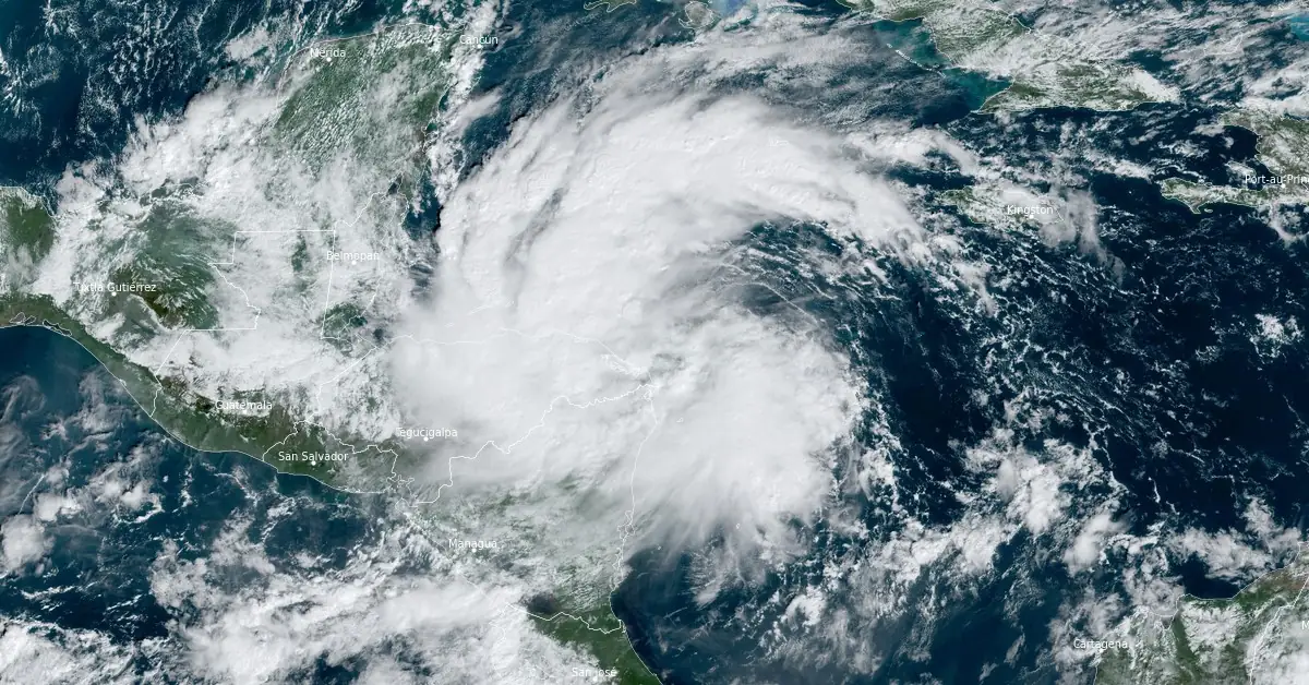
Tropical Depression 19 satellite image at 15:30 UTC on November 14, 2024. Credit: NOAA/GOES-East, RAMMB/CIRA, The Watchers
- The National Hurricane Center (NHC) forecasts heavy rainfall will lead to significant, life-threatening flash flooding and mudslides across portions of Central America, particularly in Honduras, Belize, El Salvador, eastern Guatemala, and western Nicaragua through early next week.
- Tropical storm conditions are expected along portions of the northern coast of Honduras and the adjacent Bay Islands, where tropical storm warnings are in effect.
- The system is forecast to approach Belize and the Yucatán Peninsula of Mexico by early next week, where there is a risk of strong winds. Residents in these areas should monitor the latest forecast updates.
- It is too soon to determine what impacts, if any, the system could bring to portions of the eastern Gulf of Mexico, including Florida, by the middle of next week. Residents in these areas should regularly monitor updates to the forecast.
At 15:00 UTC (10:00 EST) on November 14, the center of Tropical Depression Nineteen was located about 365 km (225 miles) east-southeast of Isla Guanaja, Honduras and 100 km (62 miles) northeast of Cabo Gracias a Dios on the Nicaragua/Honduras border, according to the National Hurricane Center (NHC).
The system had maximum sustained winds of 55 km/h (35 mph) and a minimum central pressure of 1 004 hPa.
The depression is moving westward at approximately 22 km/h (14 mph) and this motion is expected to continue through today, bringing the center near the coast of eastern Honduras.
This system is expected to linger near the northern coast of Honduras late Friday and through the weekend.
A Tropical Storm Warning is in effect for the northern coast of Honduras from Punta Sal eastward to the Honduras/Nicaragua border; and the Bay Islands of Honduras. A Tropical Storm Watch is in effect for the northeastern coast of Nicaragua from Puerto Cabezas northward to the Honduras/Nicaragua border.
Tropical storm conditions are expected within the warning area and are possible within the watch area starting later today.

“A strong mid-level ridge located to the north of the system will continue to steer the system westward towards Central America,” NHC forecaster Kelly noted.
The ridge is expected to break down, causing the cyclone to meander in weak steering currents from Friday, November 15 through the weekend.
This slow motion will likely lead to the system producing heavy rains over the same region, potentially causing life-threatening flooding in portions of Central America.
Through early next week, rainfall amounts of 250 – 500 mm (10 – 20 inches) with isolated storm totals around 760 mm (30 inches) are expected over northern Honduras. This rainfall will likely result in widespread, life-threatening, and potentially catastrophic flash flooding and mudslides, especially along and near the Sierra La Esperanza.
Across other areas of Honduras, Belize, El Salvador, eastern Guatemala, and western Nicaragua, Tropical Depression Nineteen is expected to produce 125 – 250 mm (5 – 10 inches) of rain, with localized totals up to 380 mm (15 inches) through early next week. These amounts may result in flash flooding, potentially significant, along with the possibility of mudslides, NHC warns.
In addition, storm surge may raise water levels by 0.3 – 0.9 m (1 – 3 feet) above normal tide levels along the immediate coast in areas of onshore winds along the northern coast of Honduras. Near the coast, this surge will be accompanied by large and destructive waves.
By early next week, the mid-level ridge is expected to slide eastward over Florida, likely causing the system to shift northwestward across Belize and the Yucatán Peninsula.
“Environmental and oceanic conditions are favorable for some strengthening over the next day or so while the cyclone remains over water. However, uncertainty persists regarding the extent of land interaction with Honduras over the coming days, with model trends indicating a southward shift, suggesting increased interaction,” Kelly noted.
References:
1 Tropical Depression Nineteen Advisory Number 4 – NWS/NHC – Issued at 15:00 UTC on November 14, 2024
2 Tropical Depression Nineteen Discussion Number 4 – NWS/NHC – Issued at 15:00 UTC on November 14, 2024
I'm a dedicated researcher, journalist, and editor at The Watchers. With over 20 years of experience in the media industry, I specialize in hard science news, focusing on extreme weather, seismic and volcanic activity, space weather, and astronomy, including near-Earth objects and planetary defense strategies. You can reach me at teo /at/ watchers.news.
Commenting rules and guidelines
We value the thoughts and opinions of our readers and welcome healthy discussions on our website. In order to maintain a respectful and positive community, we ask that all commenters follow these rules.