
Widespread flash flooding hits parts of Houston, Texas
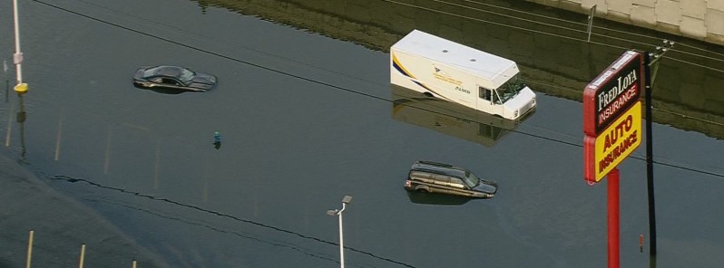
Featured image: Parts of Houston affected by widespread flash floods. Credit: The Bishop (via Twitter)
Due to torrential rainfall overnight, parts of Houston, Texas, particularly its west side, are affected by widespread flash flooding. There are multiple flood warnings and watches in effect for some creeks and bayous in the city which will remain in effect through Wednesday as another round of showers and thunderstorms is expected later today and into tonight.
Heavy overnight rains triggered widespread flash flooding in parts of Houston early Tuesday, August 8, 2017. The hardest hit was western and northern Harris County, where water flooded vehicles and entered homes and businesses.
Radar estimates and Weather Underground rainfall reports indicated 101.6 to 178 mm (4 to 7 inches) of rain had fallen generally west of U.S. 59 in Harris County.
#UPDATE: Parts of Clay Road near Bear Creek Drive in West Harris Co. still flooded. @KPRC2 #houwx #houston #kprc2 pic.twitter.com/DZsuHr4EFD
— KPRC Cathy Hernandez (@KPRC2Cathy) August 8, 2017
Flooded feeder and more at I-45 and West Mount Houston in north Houston. #khou #HouNews https://t.co/KWD0LQ6umE pic.twitter.com/8XxOWknfWN
— The Bishop (@BillBishopKHOU) August 8, 2017
Major flooding near W. Mt Houston, this is the leftover scene after heavy rain this morning. #Khou11 #houwx pic.twitter.com/ChnJMiM9GM
— Michelle Choi (@MichelleKHOU) August 8, 2017
NWS Houston warns a river flood warning remains in effect for the Halls Bayou, urging people to stay away from the river until water levels recede. Motorists should avoid any water covered roads and find an alternative route. Livestock and equipment should remain out of the flood plain for the next few days.
A Flash Flood Watch is in effect through Wednesday morning, August 9, for a portion of southeast Texas, including Chambers, Fort Bend, Harris, and Liberty counties, as a mesoscale convective vortex (upper-level disturbance) remains parked over the region.
MCV generated from t-storm cluster that -> #flooding in San Antonio Mon AM triggered the #Houston #flood this AM. See the swirl? #txwx pic.twitter.com/xlqm4x9fs8
— Jonathan Erdman (@wxjerdman) August 8, 2017
#GOES16 vis loop shows MCV responsible for the #Houston #flood event. Resembles inland #tropical cyclone remnant. (Loop: @CODMeteorology) pic.twitter.com/Ls5DS0lMCM
— Jonathan Erdman (@wxjerdman) August 8, 2017
At 06:17 CDT (11:17 UTC), NWS Houston said moderate rainfall continues to fall across much of the Houston Metro area, inhibiting the recession of flood waters. This rainfall should subside later this morning, giving a break for a portion of the day today. "However, the MCV is expected to generate another round of showers and thunderstorms later today and into tonight. Heavy rainfall will be possible with this round as well, and flooding is likely given saturated soils from this morning's rainfall."
Authorities remind residents not to drive into areas where the water covers the roadway. "The water depth may be too great to allow your car to cross safely. Vehicles caught in rising water should be abandoned quickly. If your vehicle stalls...abandon it and seek higher ground immediately. Rapidly rising water may engulf your vehicle and its occupants and sweep them away. Move to higher ground."
I'm a dedicated researcher, journalist, and editor at The Watchers. With over 20 years of experience in the media industry, I specialize in hard science news, focusing on extreme weather, seismic and volcanic activity, space weather, and astronomy, including near-Earth objects and planetary defense strategies. You can reach me at teo /at/ watchers.news.
Commenting rules and guidelines
We value the thoughts and opinions of our readers and welcome healthy discussions on our website. In order to maintain a respectful and positive community, we ask that all commenters follow these rules.