
Moderate Risk of excessive rainfall across Texas and Louisiana, flood threat forecast through June 17
Heavy rainfall is forecast from South Texas into the lower Mississippi Valley this week. Moderate Risk excessive rainfall outlooks remain in effect across parts of the Gulf Coast as multiple rounds of thunderstorms develop within an unusually moist tropical air mass. Rainfall totals could reach 100 to 150 mm (4 to 6 inches) in some areas, with locally higher amounts possible from June 15 to 17, 2026.
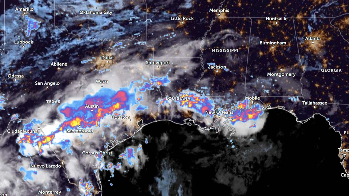
Satellite image of the US gulf coast at 10:40 UTC on June 15, 2026, with rain radar. Credit: NOAA/GOES-19, Zoom Earth, The Watchers
A prolonged heavy-rainfall event is expected to affect portions of the Gulf Coast as an unusually moisture-rich weather pattern supports repeated rounds of thunderstorms capable of producing flash flooding. The greatest concern extends from South Texas through the Texas Gulf Coast into southwest Louisiana.
The event is being driven by a combination of factors, including a strong upper-level disturbance emerging from northern Mexico, moisture associated with the remnants of former Eastern Pacific Tropical Storm Cristina, exceptionally warm Gulf waters, and a frontal boundary positioned near the Gulf Coast.
According to the Weather Prediction Center (WPC), these features are drawing deep tropical moisture northward into Texas and the western Gulf Coast, creating favorable conditions for repeated episodes of excessive rainfall.
Rainfall totals of 100 to 150 mm (4 to 6 inches) are forecast along portions of the Texas coastline into Louisiana between June 15 and 17. Locally higher totals are possible where thunderstorms repeatedly move over the same areas.
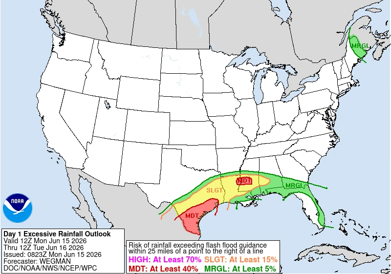
Moderate Risk covers much of the Texas Gulf Coast and South Texas, along with portions of west-central Mississippi from June 15 into June 16. Rainfall totals could reach 70 mm (2.75 inches) across Deep South Texas. These values are near record levels for mid-June.
Multiple rounds of thunderstorms are expected to develop across Deep South Texas as the upper-level disturbance approaches from Mexico.
An initial band of storms may develop during daytime heating, followed by a more persistent overnight band associated with low-level convergence. While the exact location of the convergence zone remains uncertain, areas affected by repeated thunderstorms face an elevated flash-flood threat.
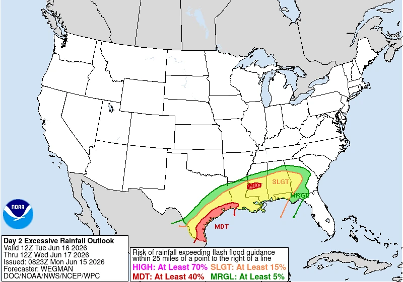
The flood threat will expand significantly on June 16 with the Moderate Risk area spreading across the entire Texas Gulf Coast.
Ongoing lee cyclogenesis ahead of the approaching disturbance to support widespread showers and thunderstorms within persistent onshore flow from the Gulf of Mexico.
Atmospheric moisture levels are forecast to remain near or above record values. This could cause thunderstorms producing exceptionally heavy rainfall even during periods when atmospheric instability is relatively limited.
The slow movement of the developing low-pressure system will allow persistent onshore flow to focus thunderstorms along portions of the middle and upper Texas coast.
Rainfall from earlier periods may lower flash-flood guidance values and increase runoff efficiency, making additional rainfall more likely to produce flooding across urban areas, including the Houston metropolitan region.
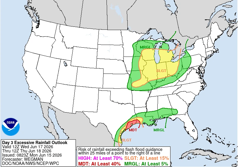
By June 17, the upper-level disturbance is forecast to move northeastward from the western Gulf toward Louisiana. WPC expects the axis of heaviest rainfall to shift toward the upper Texas Gulf Coast and southwest Louisiana.
Areas near Beaumont and the Texas-Louisiana border are likely to be the worst hit by the flash floods that may develop on June 17.
References:
1 Excessive Rainfall Outlooks – NWS/WPC – June 15, 2026
2 Short Range Forecast Discussion – NWS/WPC – June 15, 2026

I am an Assistant Editor and Severe Weather & Science Journalist at The Watchers, specializing in real-time severe weather coverage, geophysical event reporting, and research-driven scientific analysis. You can reach me at rishav(at)watchers(.)news.
Commenting rules and guidelines
We value the thoughts and opinions of our readers and welcome healthy discussions on our website. In order to maintain a respectful and positive community, we ask that all commenters follow these rules.