
Tropical Storm Bopha upgraded to typhoon
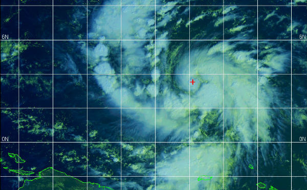
Image credit: Multispectral satellite image/23:30 UTC, November 29,2012 (JTWC/SATOPS)
Tropical Storm Bopha started to intensify and was upgraded to a typhoon status by JTWC few hours ago. Maximum sustained winds have increased to 105 km/h (65 mph). Tropical storm force winds extend outward up to 120 km (75 miles) from the center.
According to latest bulletin by NWS Guam, TY Bopha is tracking towards the Republic of Palau. The center of TS Bopha is located near latitude 3.6N and longitude 145.7 E, about 1046 km (650 miles) ESE of Ngulu and 1062 km (660 miles) SE of Yap. System is moving westward at speed of 11 mph. A gradual turn to the west-northwest with little change in forward speed is expected through tonight.
 TS Bopha forecast track (Source: JTWC)
A typhoon watch is now in effect for Ngulu in Yap state and Koror and Kayangelin in the Republic of Palau.
A tropical storm watch is in effect for Yap island in Yap state and Sonsorol in the Republic of Palau.
 TS Bopha satellite image FLOATER VISIBLE on November 30, 2012 (Credit: MTSAT/NOAA)
WFO Guam Public Advisory Bin 1
TROPICAL STORM BOPHA (26W) ADVISORY NUMBER 18
NATIONAL WEATHER SERVICE TIYAN GU WP262012
200 PM CHST FRI NOV 30 2012…TROPICAL STORM BOPHA (26W) INTENSIFYING…
…TROPICAL STORM BOPHA TRACKING TOWARDS THE REPUBLIC OF PALAU…AT 100 PM CHST…0300Z…THE CENTER OF TROPICAL STORM BOPHA WAS
LOCATED NEAR LATITUDE 3.6 DEGREES NORTH AND LONGITUDE 145.7 DEGREES
EAST.THIS IS ABOUT 650 MILES EAST-SOUTHEAST OF NGULU
660 MILES SOUTHEAST OF YAP
815 MILES EAST-SOUTHEAST OF KOROR PALAU AND KAYANGEL
935 MILES EAST OF SONSOROL.TROPICAL STORM BOPHA IS NOW MOVING WEST AT 11 MPH. A GRADUAL TURN TO
THE WEST-NORTHWEST WITH LITTLE CHANGE IN FORWARD SPEED IS EXPECTED
THROUGH TONIGHT.MAXIMUM SUSTAINED WINDS HAVE INCREASED TO 65 MPH. TROPICAL STORM
BOPHA IS EXPECTED TO INTENSIFY TODAY…POSSIBLY BECOMING A TYPHOON
BY TONIGHT. TROPICAL STORM FORCE WINDS EXTEND OUTWARD UP TO 75 MILES
FROM THE CENTER.
 Multispectral satellite image (Source: JTWC/SATOPS)
Continued favorable environmental conditions, including enhanced poleward outflow toward the based of this developing trough and passage over very warm water, should allow for steady intensification.
Satellite Animations
- Storm-Centered Infrared (MTSAT; NOAA/SSD)
- Storm-Centered Infrared (Aviation Color Enhancement) (MTSAT; NOAA/SSD)
- Storm-Centered Water Vapor (MTSAT; NOAA/SSD)
- Storm-Centered Visible (MTSAT; NOAA/SSD)
- Storm-Centered Visible (Colorized) (MTSAT; NOAA/SSD)
- Tropical West Pacific Infrared (MTSAT2; NOAA)
- Tropical West Pacific Enhanced Infrared (MTSAT2; NOAA)
- Tropical West Pacific Water Vapor (MTSAT2; NOAA)
- Tropical West Pacific Visible (MTSAT2; NOAA)
 Western/South Pacific Ocean globe view (Credit: JTWC/SATOPS)
must be something in the air thats changing our planet can someone explain.
The word you should be looking for is torque. The Coriolis effect is not the only means to spin up a cyclone.
how can a tropical storm form this close to the equator with counterclockwise rotation 3.6 degrees north defies corlis effect from earths rotation must be something in the air thats changing our planet can someone explain.