
Storm Éowyn batters UK after bringing record winds to Ireland, leaves over 700 000 homes without power
Storm Éowyn battered Ireland with record-breaking winds on Friday, January 24, 2025, and impacted the UK with gusts of over 145 km/h (90 mph), causing more than 700 000 power outages.

Satellite image of Storm Eowyn. Image credit: Eumesat/Meteosat, Zoom Earth, The Watchers. Acquired at 12:20 UTC on January 24, 2025
- Storm Éowyn brought record-breaking winds of 183 km/h (114 mph) to Ireland, surpassing the previous record of 182 km/h (113 mph).
- Over 700 000 customers across the UK and Ireland experienced power outages due to downed trees, powerlines, and other storm-related damages.
- Red, Amber, and Yellow warnings for wind, snow, and ice remain in effect across the UK, with the strongest winds impacting Northern Ireland, western, and central Scotland.
- After Storm Éowyn weakens, another low-pressure system is forecast to arrive on Sunday, January 26, bringing more strong winds and heavy rain to parts of the UK.
Ireland experienced the strongest impact of Storm Éowyn on Friday morning, January 24, with record-breaking winds of 183 km/h (114 mph) measured at Mace Head, provisionally surpassing the previous highest gust record of 182 km/h (113 mph).
Éowyn hit the UK with winds exceeding 145 km/h (90 mph) recorded in Northern Ireland and parts of northern Wales on Friday morning.
Several other regions of the UK also reported strong winds, with the highest gusts recorded at Aberdaron at 150 km/h (93 mph), followed by Killowen at 148 km/h (92 mph).
The storm has caused significant damage, leaving more than 700 000 customers without power due to downed trees, powerlines, and other storm-related disruptions.
As it moves northeast, the strongest winds are expected to affect Northern Ireland and parts of western and central Scotland. Red, Amber, and Yellow warnings remain in place across the UK.
Warnings and alerts associated with Éowyn
Red, Amber, and Yellow wind warnings are in effect through Friday, with the most severe and disruptive gusts expected in Northern Ireland and western and central Scotland.
Amber and Yellow wind warnings remain in effect into the early hours of Saturday, January 25, for northern Scotland.
A Yellow snow warning is in effect on Friday for northern and central Scotland. Accumulations are expected over high ground, while lower levels are likely to see sleet and rain throughout the day.
Multiple Yellow warnings for snow and ice have been issued from late Friday into Saturday morning.
The focus will shift to the next low-pressure system arriving on Sunday, January 26, and continuing into Monday, January 27, which is expected to bring additional strong winds and periods of heavy rain.
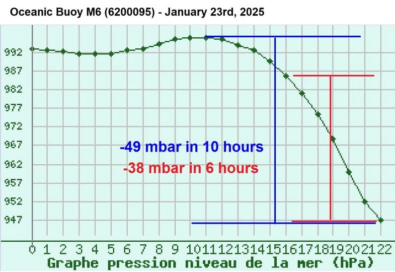
Cyclogenesis of Storm Éowyn
The storm developed into a bomb cyclone after its central pressure decreased by 49 hPa in 10 hours on Thursday.
Within six hours, the storm’s pressure dropped by 38 hPa at a rate exceeding 6 hPa per hour. By 22:00 local time (LT), the storm’s central pressure had fallen to 947 hPa from 992 hPa earlier that day.
Cyclogenesis refers to the development or strengthening of a low-pressure system. When the central pressure drops by at least 24 hPa within 24 hours, the system undergoes bomb cyclogenesis, resulting in a bomb cyclone.
Forecast for Storm Éowyn
Saturday is expected to remain breezy, with strong winds continuing in the north as Éowyn weakens and moves northeast of the UK. Many areas will see drier conditions, with showers replacing heavy rain. Wintry conditions are expected in the north, particularly over higher ground.
However, a new low-pressure system is expected to influence the UK from Sunday, initially affecting the west before spreading north and east. This system will bring additional strong winds and rain into the start of next week, with further warnings issued.
“While the worst of Storm Éowyn’s winds will ease later on Friday, Scotland will continue to experience gusty conditions on Saturday as the low-pressure system moves northeastward,” Met Office Deputy Chief Meteorologist Mark Sidaway stated.
“After a brief calmer spell, another low-pressure system will bring more strong winds and heavy rain on Sunday,” Sidaway added.
The strongest winds are expected in western regions, while the heaviest rainfall is likely across Wales, central, and southern England. Although this system is not expected to be as severe as Storm Éowyn, it could hinder recovery efforts in areas affected by Friday’s storm.
References:
1 Storm Éowyn brings 90mph winds as it starts to impact the UK – Met Office – January 24, 2024

I am an Assistant Editor and Severe Weather & Science Journalist at The Watchers, specializing in real-time severe weather coverage, geophysical event reporting, and research-driven scientific analysis. You can reach me at rishav(at)watchers(.)news.
Commenting rules and guidelines
We value the thoughts and opinions of our readers and welcome healthy discussions on our website. In order to maintain a respectful and positive community, we ask that all commenters follow these rules.