
Seismic activity near Grjótárvatn increases, attributed to deep magmatic intrusion, Iceland
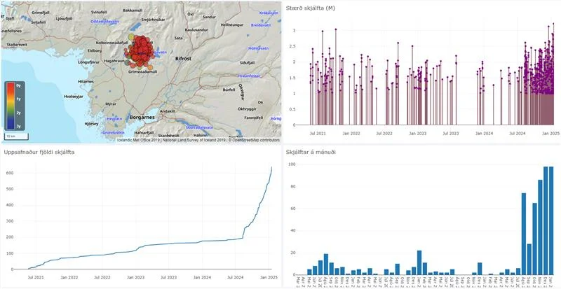
An M3.2 earthquake was recorded during the ongoing seismic activity near Grjótárvatn, Iceland, on January 16, 2025. It was the strongest event since August 2024. Nearly 100 earthquakes above M1 were recorded in January alone, matching the highest monthly count previously recorded in December 2024.
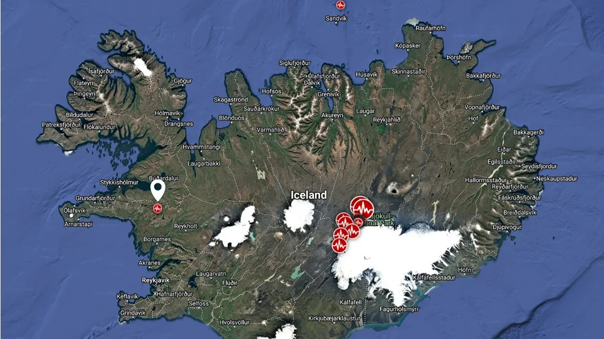
Image credit: TW/SAM, Google
- Grjótárvatn lies within the Ljósufjöll volcanic system in the Snæfellsnes Volcanic Zone.
- Magma intrusion at depth is considered the most likely cause of seismic activity.
- There are currently no indications that magma is moving toward the surface.
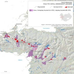
- Ljósufjöll’s last eruption occurred in the 10th century CE and produced the Rauðhálsahraun lava field which spaned 13 km2 (5 mi2).
Seismic activity near Grjótárvatn, Iceland, continues to increase with nearly 100 earthquakes above M1 recorded in January. The most recent event, an M3.2 earthquake on January 16, is the strongest in the region since activity intensified in August 2024.
The Icelandic Meteorological Office (IMO) attributes the ongoing seismicity to a deep magmatic intrusion, though there is currently no indication of magma moving toward the surface.
A tremor episode lasting approximately 40 minutes was detected on January 2, followed by another on January 10. The episodes consisted of continuous small earthquakes most of which were too minor to be detected.
Two earthquakes on January 2 had magnitudes of 1.5 and 1.8 and they originated at a depth of approximately 15 km (9.3 miles). Around 20 earthquakes were recorded all at depths of 15 to 20 km (9.3 to 12.4 miles) with magnitudes between 0.1 and 2.0.
A monthly review meeting held at the IMO on January 8 analyzed the ongoing seismic activity which exhibits an unusually high b-value (~2). The pattern is common in volcanic areas and indicates a high proportion of small earthquakes which suggests that the activity is driven by deep magmatic processes rather than tectonic movements.
“High b-values of ~2, as observed here, are indicative of volcanic activity,” IMO stated.
No measurable ground deformation has been detected from GNSS observations or satellite-based InSAR data. The IMO noted that magma accumulation at depths greater than 16 km (10 miles) may not immediately produce detectable surface deformation until volumes are involved.
An M3.1 earthquake was recorded on December 18, 2024, making it the largest event in the area since 2 earthquakes of M3.0 occurred in 2021. Reports indicated that residents in Borgarfjörður and Akranes felt the earthquake.
Seismic activity around Grjótárvatn has been ongoing since spring 2021 but has shown an increase in recent months.
The IMO installed a new seismometer in Hítardalur at the end of September 2024 and a GNSS station in early November. The new seismometer has improved the detection of smaller earthquakes below M1.0.
The increase in seismicity is not attributed to improved monitoring alone as earthquakes above M1.0 were increasing before the installation of the station.
Deep earthquakes are uncommon in Iceland though similar activity has been observed in volcanic systems such as Eyjafjallajökull in 1996, Upptyppingar in 2007, and east of the Bárðarbunga caldera. Deep seismicity results from pressure buildup in the crust because of magmatic intrusion in such cases which leads to deformation and small-magnitude earthquakes.
Analysis of earthquake data from 2021 to 2024 near Grjótárvatn shows a Gutenberg-Richter b-value of ~2 which is consistent with other volcanic regions. It suggests a magmatic origin for the earthquakes although there are no signs of magma rising toward the surface.
The IMO has elevated the monitoring level for Ljósufjöll which is the volcanic system in which Grjótárvatn is located. Enhanced monitoring plans include deploying additional instruments to improve surveillance and better understand the seismic activity.
Read more:
The Ljósufjöll volcanic system is situated in the Snæfellsnes Volcanic Zone and it last erupted in the 10th century CE by producing the 13 km2 (5 mi2) Rauðhálsahraun lava field.
Over the past 10 000 years, eruptions in this system have occurred approximately every 400 years as small effusive, or mildly explosive events. Potential hazards in the event of an eruption include localized lava flows, gas emissions, and tephra fallout.
References:
1 Earthquakes continue to be recorded at great depths near Grjótárvatn – IMO – January 17, 2025
2 Ljósufjöll – GVP – Accessed on Janaury 10, 2025

Rishika holds a Master’s in International Studies from Stella Maris College, Chennai, India, where she earned a gold medal, and an MCA from the University of Mysore, Karnataka, India. Previously, she served as a Research Assistant at the National Institute of Advanced Studies, Indian Institute of Science, Bengaluru, India. During her tenure, she contributed as a Junior Writer for Europe Monitor on the Global Politics website and as an Assistant Editor for The World This Week. Her work has also been published in The Hindu newspaper, showing her expertise in global affairs. Rishika is also a recipient of the Women Empowerment Award at the district level in Haryana, India, in 2022.
Commenting rules and guidelines
We value the thoughts and opinions of our readers and welcome healthy discussions on our website. In order to maintain a respectful and positive community, we ask that all commenters follow these rules.