
Severe winter storms to bring heavy snow, ice, and extreme cold across the U.S.
A powerful sequence of winter storms is set to impact large portions of the U.S. over the next 7 days. It will bring heavy snow to the Northeast, disruptive ice accumulation across the South, and life-threatening cold temperatures extending from the Northern Plains to the Gulf Coast.
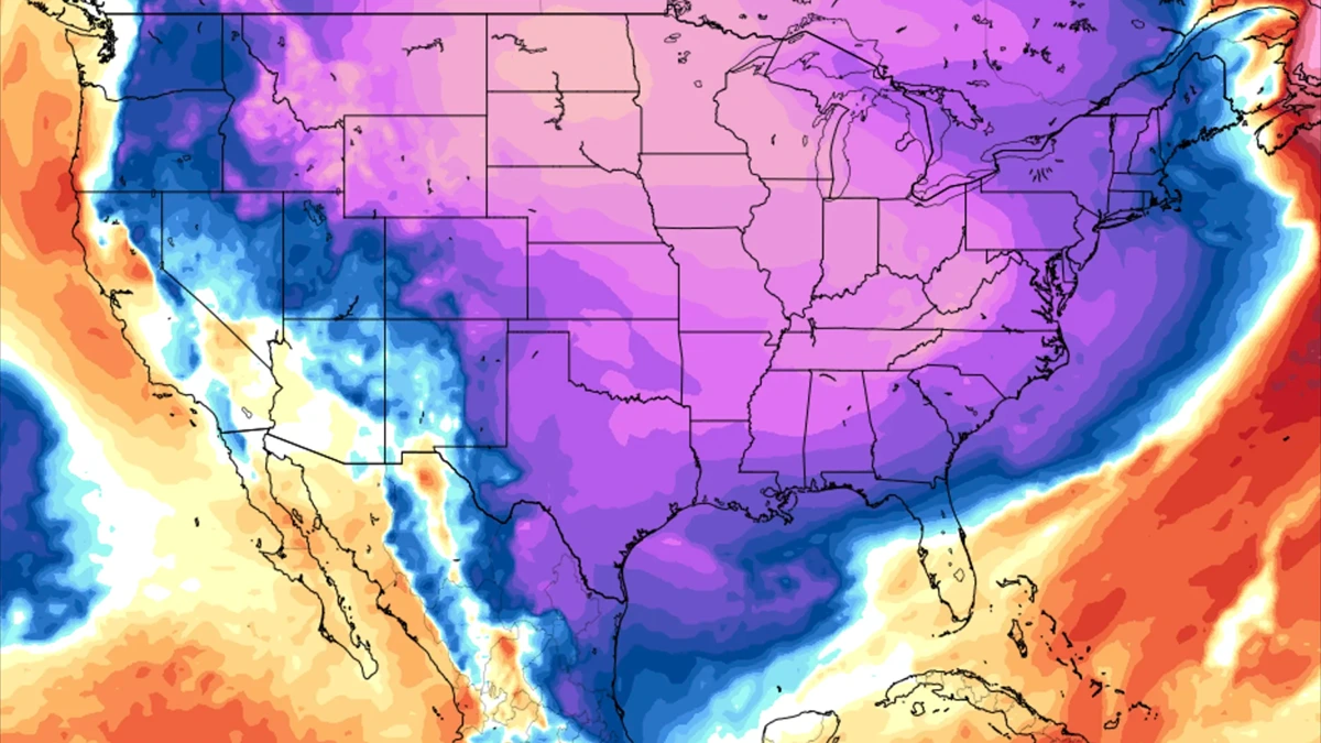
GFS forecast map showing 850 hPa temperature anomalies in degrees Celsius for January 20, 2025, based on the 1981-2010 climatology. Image credit: TropicalTidbits
A developing winter storm will bring snowfall from West Virginia to southern New England beginning on the morning of Sunday, January 19, 2025. The heaviest snowfall is expected north and west of the Interstate 95 corridor while 3 to 15 cm (1 to 6 inches) of snow could accumulate from northern Maryland through Boston. Localized higher totals may occur in eastern Maine.
Snowfall will begin in West Virginia and northern Virginia on January 19 which will progress northeastward through the day and reach southern New England by the evening. Travel disruptions are expected with hazardous conditions persisting through Sunday night.
Forecast snowfall totals range from 8 to 15 cm (3 to 6 inches) across northern Maryland to Boston. Areas north and west of I-95 can expect between 10 and 30 cm (4 to 12 inches) while eastern Maine may see locally higher amounts exceeding 30 cm (12 inches).
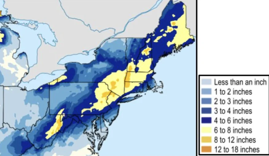
Bitterly cold air will follow in the storm’s wake with temperatures between 8 to 14 °C (15 to 25 °F) below normal from Monday through Wednesday. Roadways will become icy and will increase travel risks.
Winter storm severity levels indicate moderate to hazardous travel conditions through Monday. Uncertainty remains regarding the exact location of the heaviest snowfall and further updates are expected.
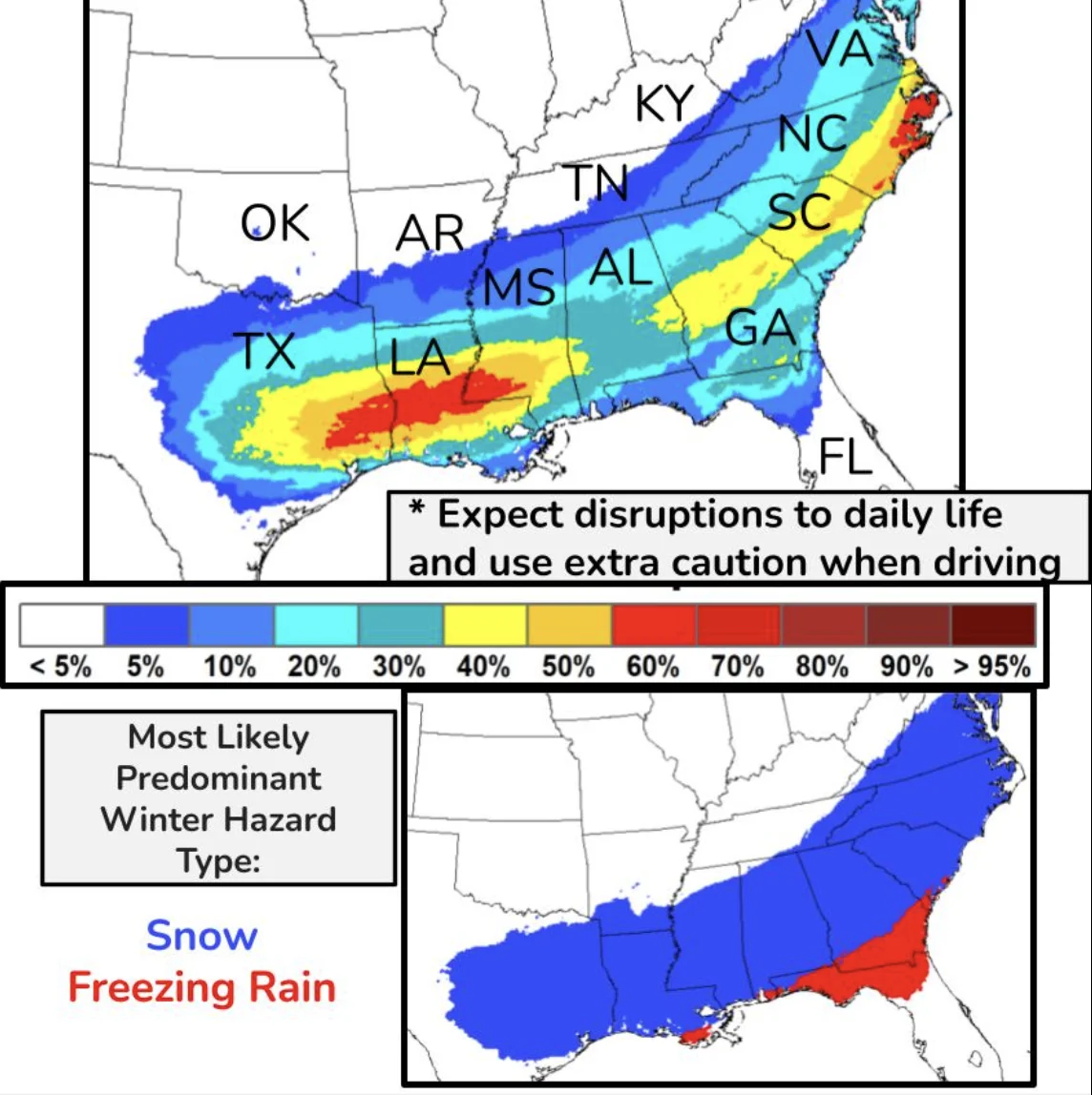
A second winter storm is expected to impact parts of the Deep South beginning Monday night, bringing snow, freezing rain, and travel disruptions from eastern Texas to the Southeast.
Snowfall is projected near and just south of the Interstate 20 corridor while freezing rain is likely closer to the Interstate 10 corridor.
Hazardous conditions will extend across multiple states including Texas, Louisiana, Mississippi, Alabama, and Georgia. Widespread traffic disruptions and flight delays are expected given the lack of snow removal equipment in these regions.
Heavy snow accumulation is expected near I-20 while ice accumulation near I-10 may result in downed trees and power outages. Sub-freezing temperatures are predicted to persist along the Gulf Coast throughout the week.
Colder-than-normal temperatures will persist before and after the storm which will increase the risk of infrastructure damage. Residents in affected areas should prepare for prolonged power outages because of ice accumulation on power lines and trees.

An Arctic air mass is sweeping across the U.S. and will be bringing some of the coldest temperatures in years. The cold front, moving south from the Northern Plains, will reach the Southern Plains and Ohio Valley by Sunday before spreading eastward.
Sub-zero wind chills will extend as far south as Oklahoma and the Tennessee Valley by Sunday night with bitter cold lingering along the Gulf Coast through next week.
Projected wind chill values indicate temperatures ranging from –30 to –55 °C (–22 to –67 °F) in the Northern Plains and Upper Midwest and –20 to –40 °C (–4 to –40 °F) in the Rockies. The Ohio and Tennessee Valleys are expected to experience wind chills between –10 and –25°C (14 to –13 °F) while the Southeastern U.S. will face near or below-freezing conditions for several days.
Cold weather safety measures include staying indoors whenever possible during early mornings when temperatures are at their lowest. It is important to insulate exposed pipes and keep water faucets dripping to prevent freezing.
Ensuring fuel tanks and batteries are at least half full can help maintain heating during emergencies. Carrying a cold-weather survival kit while traveling is also recommended to stay prepared.
References:
1 Key Messages for January 19-20 Northeast Winter Storm – NWS/WPC – January 17, 2025

Rishika holds a Master’s in International Studies from Stella Maris College, Chennai, India, where she earned a gold medal, and an MCA from the University of Mysore, Karnataka, India. Previously, she served as a Research Assistant at the National Institute of Advanced Studies, Indian Institute of Science, Bengaluru, India. During her tenure, she contributed as a Junior Writer for Europe Monitor on the Global Politics website and as an Assistant Editor for The World This Week. Her work has also been published in The Hindu newspaper, showing her expertise in global affairs. Rishika is also a recipient of the Women Empowerment Award at the district level in Haryana, India, in 2022.
Commenting rules and guidelines
We value the thoughts and opinions of our readers and welcome healthy discussions on our website. In order to maintain a respectful and positive community, we ask that all commenters follow these rules.