
U.S. braces for Arctic blast and major Northeast winter storm
The National Weather Service (NWS) Weather Prediction Center (WPC) has issued 2 Key Messages for impactful winter weather — one for an intense Arctic blast that arrives this seeking and the other for an impending winter storm set to impact the the Northeast this weekend.

A forecast map from the National Weather Service (NWS) shows minimum wind chill values across the U.S. from January 18 to January 22, 2025. Image credit: NWS/WPC
The Weather Prediction Center (WPC) has released 2 sets of messages related to the ongoing Arctic blast and an upcoming winter storm expected to affect the Northeast on January 19 and 20. The Arctic cold front is set to bring dangerously low temperatures across large portions of the country while the winter storm will produce heavy snowfall along the I-95 corridor.
A powerful Arctic air mass will begin moving southeast from the Rockies on Friday, January 17, 2025, bringing extreme cold and hazardous wind chills across multiple states. The Arctic outbreak will cause minimum wind chills to drop as low as -34 °C (-30 °F) in parts of Montana, North Dakota, and Minnesota.
Below-freezing wind chills will extend by January 19 into Texas, Oklahoma, and the lower Mississippi Valley. The National Weather Service (NWS) warns that these conditions pose a high risk of hypothermia and frostbite.
Wind chills below -18 °C (0 °F) will spread into the southern Plains and Ohio Valley by January 19 and will persist into January 21. The Arctic air mass will remain entrenched along the Gulf Coast and southeastern U.S. through January 23.

A winter storm is forecast to impact the Northeast beginning Sunday, January 19, bringing widespread snowfall from West Virginia to southern New England.
Snow will start in Virginia and the Delmarva region in the morning before moving northward along the I-95 corridor. The heaviest snowfall is expected between Washington, D.C., and Boston, with potential accumulations of 8 to 15 cm (3 to 6 inches).
The winter storm will be followed by an Arctic cold front on January 20, bringing the coldest air of the season to the region. High temperatures on Monday, January 20, are forecast to be 8 to 14 °C (15 to 25 °F) below normal, increasing the risk of icy road conditions and cold-related illnesses.
Meteorologists caution that forecast changes are likely as the storm develops. Residents are encouraged to follow the latest updates from the NWS for precise snowfall predictions and impact areas.
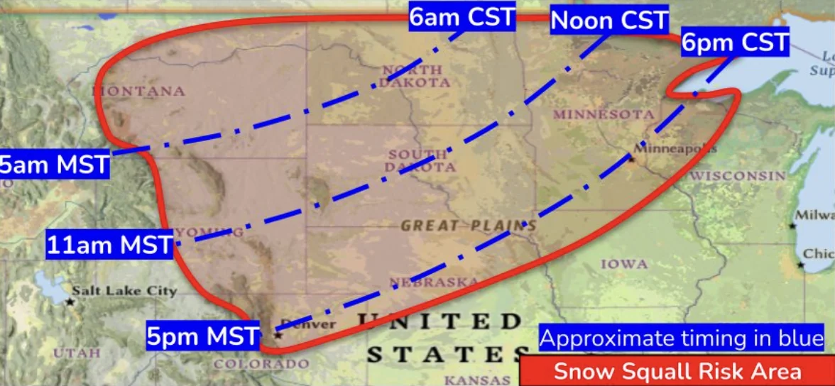
Snow squalls will develop as the Arctic front advances and will lead to hazardous travel conditions. Snow squalls which produce sudden bursts of heavy snowfall and strong winds are expected to begin on Thursday, January 16, in Montana and continue into the central Rockies and High Plains on January 17.
The NWS warns that snow squalls may cause sudden whiteout conditions, icy roads, and deteriorating visibility, making travel extremely dangerous.
References:
1 Key Messages for January 19 – 20 Winter Storm and January 17 – 24 Cold Weather – NWS/WPC – January 17, 2025

Rishika holds a Master’s in International Studies from Stella Maris College, Chennai, India, where she earned a gold medal, and an MCA from the University of Mysore, Karnataka, India. Previously, she served as a Research Assistant at the National Institute of Advanced Studies, Indian Institute of Science, Bengaluru, India. During her tenure, she contributed as a Junior Writer for Europe Monitor on the Global Politics website and as an Assistant Editor for The World This Week. Her work has also been published in The Hindu newspaper, showing her expertise in global affairs. Rishika is also a recipient of the Women Empowerment Award at the district level in Haryana, India, in 2022.
Commenting rules and guidelines
We value the thoughts and opinions of our readers and welcome healthy discussions on our website. In order to maintain a respectful and positive community, we ask that all commenters follow these rules.