
Widespread winter disruptions forecast for Europe as Arctic air advances
Europe is bracing for widespread winter weather disruptions as an Arctic air mass pushes southward, triggering heavy snowfall, rain, and blizzards over the next couple of days. This shift, marked by a deep trough, will bring near-blizzard conditions to Sweden and Finland, while northern Italy and the Balkans face the risk of flash floods and heavy snow. Coastal regions of the UK and Ireland are also on alert for a powerful storm system with 150 km/h (93 mph) winds by the weekend.

First snow of the season in Aberdeenshire Scotland. Image credit: Jane Barlow
- A powerful Arctic air mass is forecast to disrupt weather patterns across Europe, bringing widespread snowfall, severe winter storms, and intense winds.
- Southern Sweden and Finland are set to experience blizzard conditions, with heavy snow accumulation expected through the midweek and into the weekend.
- A significant low-pressure system will strengthen over northern Europe by November 20, fueled by Arctic air, intensifying snowfall and storms.
- Most Scandinavian countries, central Europe, and parts of the Balkans, including Slovenia and Croatia, are forecast to receive heavy snow, with local accumulations reaching up to 40 cm (15.7 inches) in some areas.
According to an analysis by Marko Korosec of Severe Weather Europe, an Arctic air mass is forecast to dominate the region over the next couple of days, bringing widespread snowfall, intense winter storms, and strong winds. This follows weeks of stable weather under the influence of a blocking high over the continent.
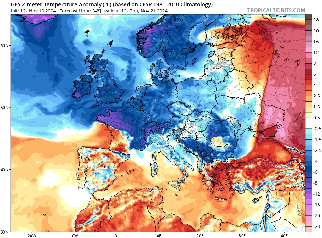
Satellite imagery on November 17 revealed a stable atmospheric setup over the Atlantic and Greenland, with a strengthening trough extending across northern Europe. This system showed the start of the Arctic intrusion, forecast to intensify and spread southward by November 19. Cold air is already being funneled between the trough and the European continent, laying the groundwork for rapidly developing frontal systems.
The Arctic air mass will first impact western and northern Europe, signaling the start of a more dynamic weather period. This shift is expected to drive multiple frontal systems, causing heavy snow, rain, and blizzard conditions across extensive areas.
A major low-pressure system is set to intensify over northern Europe on November 20, fueled by Arctic cold air. Heavy snow is predicted along the cold side of the system, with southern Sweden and Finland facing intense blizzard conditions.
Southern Sweden is forecast to experience heavy snowfall throughout November 20, intensifying as the system shifts northeast. Central Sweden and southern Finland are expected to encounter near-blizzard conditions from the night of November 20 into the morning of November 21. Snow will persist across the Baltic region as the low-pressure system weakens on November 21, leaving a wintry landscape with widespread snow showers.
Warm air ahead of the system may briefly raise temperatures in parts of the Baltic, but conditions are expected to remain cold enough for snowfall, particularly in Estonia during the initial phase.
Significant snow accumulation is predicted for most Scandinavian countries through the weekend, with the heaviest amounts expected in southern Sweden and southern Finland due to the low-pressure system’s central path.
The UK and Ireland are also expected to feel the Arctic air’s effects. Northern England, Scotland, Wales, and the Midlands have already seen some snow on November 19, driven by a rapidly developing winter storm and may get more snowfall on November 20.
Snow accumulations will depend on the low-pressure system’s precise position, though northern areas are likely to experience significant snowfall.
As the Arctic air mass extends into central Europe, the Alps and Balkan regions will come under its influence. By November 21, cold air interacting with the Alps is expected to generate a secondary low-pressure system over northern Italy. This system may deepen quickly, with central pressure possibly falling below 990 hpa
Northern Italy and the Adriatic region are forecast to experience heavy rainfall and severe thunderstorms, with a risk of flash floods. Colder areas, especially in the Alps, are likely to see precipitation turn to snow.
Strong Bora winds are expected to intensify blizzard conditions locally. Heavy snowfall of 15 – 40 cm (5.9 – 15.7 inches) is forecast across parts of Slovenia and Croatia on November 22.
The Alps, Balkan countries, and regions including Austria, Hungary, and western Romania are likely to receive significant snow. However, the amount will depend on the secondary low-pressure system’s track: a northerly route could bring warmer air and rain, while a southerly path may result in colder weather and heavier snow.
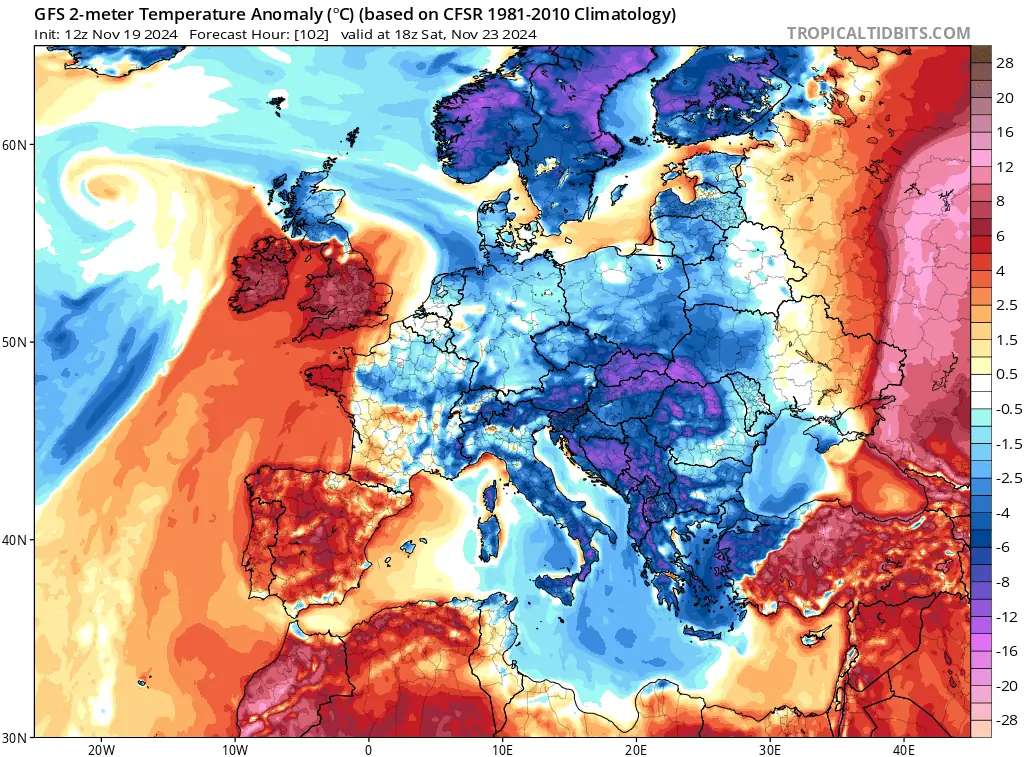
Attention will return to Western Europe by the weekend, as a deep trough forms over the Atlantic. A large low-pressure system is expected to approach Ireland and the UK on November 23, with central pressure dropping to around 950 hpa, triggering a powerful storm with violent winds and widespread effects.
Winds are expected to reach up to 150 km/h (93 mph), particularly along the Irish coast. Significant wave activity poses coastal risks. Heavy rain squalls will move through the region, and Scotland may see some snow, depending on residual cold air before the warm sector arrives.
Due to its size and strength, the storm is expected to impact much of western Europe, including France and the Benelux region. Its intensity, coupled with heavy precipitation, may disrupt travel and cause localized damage.
Two dominant features are driving the weather: a large upper trough over Europe and a blocking High near the Azores. Together, they produce a strong jet stream with wind speeds of 240 – 278 km/h (150 – 173 mph). This jet stream fuels storm development and impacts aviation, reducing eastbound flight times but causing turbulence and delays for westbound flights.
Cold Arctic air will continue to influence the region, with precipitation increasingly occurring as snow. The interaction of cold advection aloft and deepening surface lows is expected to result in varied winter weather, including snowstorms, rain, and freezing rain.
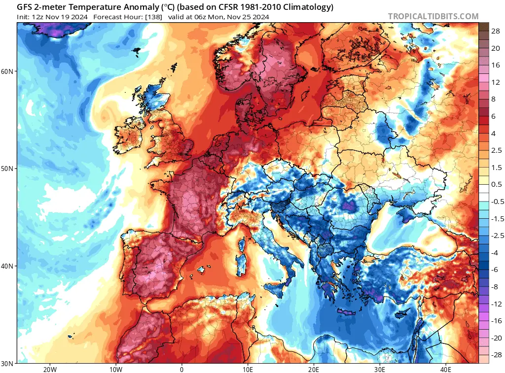
Toward the end of the week, as the deep trough weakens and shifts eastward, a blocking High is expected to form over southern Europe, temporarily bringing warmer air to the Balkan Peninsula. However, western Europe is forecast to remain under the influence of the Atlantic storm system, maintaining unsettled conditions.
References:
1 Winter Storm Alert: Prepare for intense weather across Europe – SWE – November 18, 2024

I am an Assistant Editor and Severe Weather & Science Journalist at The Watchers, specializing in real-time severe weather coverage, geophysical event reporting, and research-driven scientific analysis. You can reach me at rishav(at)watchers(.)news.
Commenting rules and guidelines
We value the thoughts and opinions of our readers and welcome healthy discussions on our website. In order to maintain a respectful and positive community, we ask that all commenters follow these rules.