
Rio Grande do Sul and Santa Catarina brace for intense rainfall
Southern Brazil is bracing for heavy torrential rainfall between Tuesday and Wednesday, November 19 – 20, 2024, with regions like Rio Grande do Sul and Santa Catarina expected to experience precipitation exceeding 100 mm (3.94 inches), according to MetSul Meteorologia.
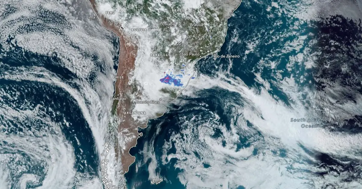
Satellite image of South America with rainfall radar acquired at 17:00 UTC on November 19, 2024. Credit: NOAA/GOES-East, Zoom Earth, The Watchers
- Southern Brazil is expected to experience significant rainfall, with amounts exceeding 100 mm (3.94 inches) in some areas, particularly in Rio Grande do Sul and Santa Catarina, from Tuesday to Wednesday, November 19-20, 2024.
- A low-pressure system combined with warm, humid air will drive the formation of intense clouds, leading to heavy rain and isolated thunderstorms
- The heavy rainfall, especially in Porto Alegre, Greater Serra, and northern coastal areas, raises the risk of flooding, flash floods, and landslides, worsened by orographic effects in hilly regions.
MetSul Meteorologia has issued a warning about a major weather event that is expected to bring heavy torrential rainfall to southern Brazil.
This instability is forecast to affect the region from Tuesday to Wednesday, with precipitation potentially exceeding 100 mm (3.94 inches) in some areas. The highest rainfall totals are anticipated in Rio Grande do Sul and Santa Catarina, while isolated heavy rain may also occur in parts of Paraná.
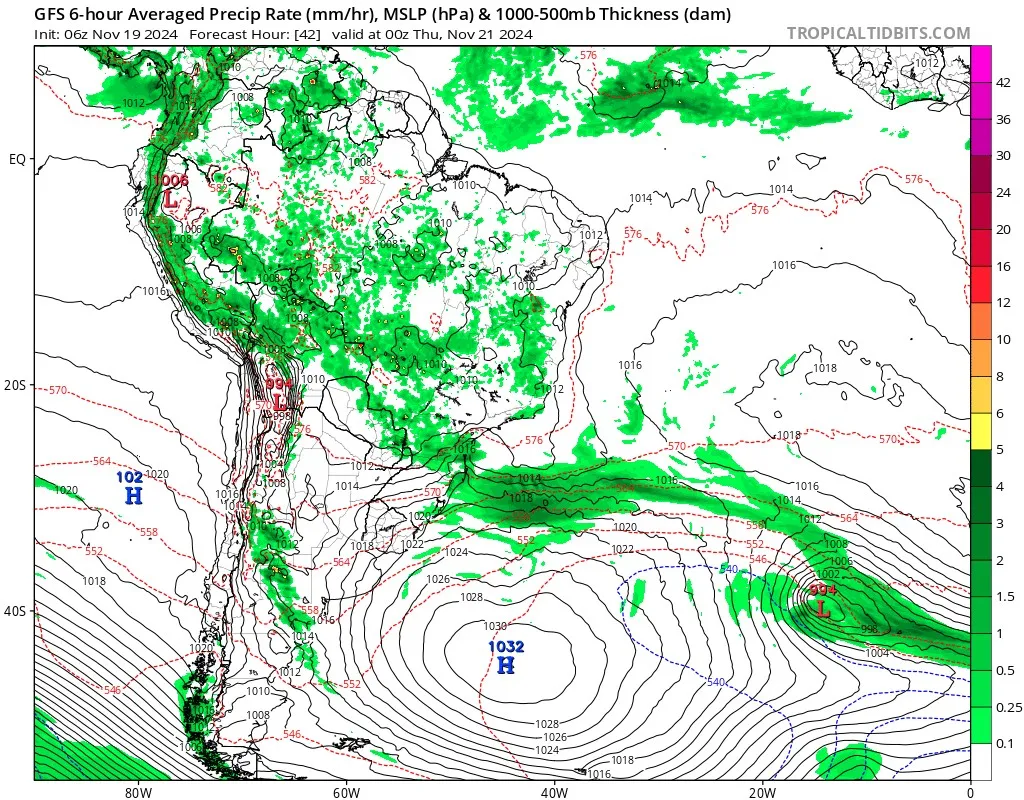
The rainfall is driven by a low-pressure system forming over southern Brazil. The system will generate vertically developed clouds, intensifying precipitation in the affected regions. Warm and humid air is fostering the formation of intense clouds, increasing the likelihood of heavy rain.
Isolated thunderstorms may occur during this period of instability, though the primary concern is heavy rainfall. The pressure difference between the low-pressure area in southern Brazil and a high-pressure center measuring nearly 1 030 hPa east of Argentina is expected to cause moderate to occasionally strong easterly winds, especially on Tuesday and Wednesday.
Rainfall began early Tuesday morning in Rio Grande do Sul and Santa Catarina. However, its intensity is expected to rise in the afternoon and evening. The period of greatest concern is from late Tuesday night into Wednesday morning, when intense rainfall is forecast to move from central Rio Grande do Sul toward the east and northeast, affecting the valleys, Greater Porto Alegre, parts of the Serra region, and the northern coast.
By Wednesday afternoon and evening, the most intense instability is expected to move offshore, allowing intermittent sunshine. While isolated rain may persist, weather conditions are forecast to improve significantly by Thursday, with sunny intervals across much of the region and only brief, localized showers in some areas.
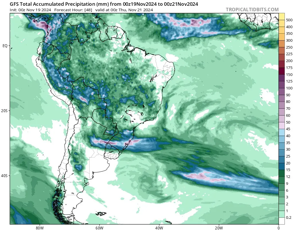
High-resolution weather models from the U.S. GFS and European ECMWF suggest that rainfall totals over the 72-hour period through 21:00 local time (LT) Wednesday could range from 50 mm to 100 mm (1.97 to 3.94 inches) in many areas, with localized amounts exceeding 100 mm (3.94 inches). Central and northern Rio Grande do Sul and parts of Santa Catarina are projected to face the highest risk of significant rainfall.
Heavy rainfall is expected in Porto Alegre and its metropolitan area, particularly during the first half of Wednesday. This could result in flooding, flash floods, and landslides in vulnerable areas.
Orographic rainfall, driven by the region’s terrain, may worsen conditions. Moist easterly winds, fueled by a high-pressure system east of Argentina and above-average Atlantic Ocean temperatures, will transport moisture toward the Serra do Mar region. As this moist air meets the mountains, it rises, cools, and condenses into rain, potentially resulting in extremely high precipitation volumes in localized areas.
The Torres region on the northern coast of Rio Grande do Sul and the southern and eastern slopes of the Serra in Santa Catarina are especially vulnerable. This process often generates rainfall volumes surpassing numerical model predictions, heightening the risk of flooding and landslides in these areas.
Moderate to strong easterly winds, resulting from the pressure contrast between the low-pressure system and the high-pressure center, are also expected on Tuesday and Wednesday. These winds may enhance moisture transport and contribute to localized severe weather conditions.
Isolated thunderstorms are possible, but heavy rainfall remains the main concern. Coastal areas of Santa Catarina, São Paulo, and Rio de Janeiro, which are historically prone to extreme orographic rainfall events, should remain vigilant.
In May 2024, southern Brazil, particularly the states of Rio Grande do Sul and Santa Catarina, experienced severe flooding due to heavy rainfall.
The capital city, Porto Alegre, experienced widespread flooding, rendering roads impassable and leading to the suspension of flights at the main airport. The floods resulted in significant displacement, with over 208 000 people forced from their homes and at least 1.5 million residents impacted.
Additionally, more than 1.4 million individuals were left without electricity, and 48 cities faced telecommunications outages.
The agricultural sector suffered extensive damage, disrupting the production and export of key commodities such as soy, rice, wheat, and meat. Authorities closely monitored several dams, including the partially collapsed 14 de Julho dam in Cotiporã municipality, to prevent further disasters.
Read more:
1CHUVA FORTE A INTENSA OFERECE RISCOS EM ESTADOS DO SUL DO BRASIL – MetSul – November 18, 2024

I am an Assistant Editor and Severe Weather & Science Journalist at The Watchers, specializing in real-time severe weather coverage, geophysical event reporting, and research-driven scientific analysis. You can reach me at rishav(at)watchers(.)news.
Commenting rules and guidelines
We value the thoughts and opinions of our readers and welcome healthy discussions on our website. In order to maintain a respectful and positive community, we ask that all commenters follow these rules.