
Heavy rain causes flooding and stream overflows across São Paulo, Brazil
Heavy thunderstorms caused flooding and stream overflows in São Paulo city and the metropolitan area during the afternoon of March 8, 2026, prompting flood alerts in several districts. Authorities reported overflowing streams, flooded streets, and at least 180 flooding-related emergency calls as intense rainfall affected the region. Additional rainfall is forecast through March 11, keeping the risk of flooding and landslides elevated across parts of the state.
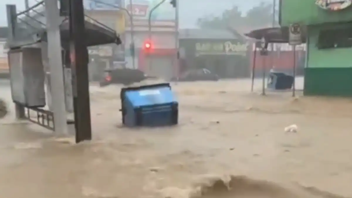
Image credit: Disaster News
Heavy rainfall affected several districts of São Paulo during the afternoon of March 8, producing flooding and stream overflows across parts of the metropolitan area. Intense thunderstorms generated rapid rainfall accumulation that overwhelmed drainage systems and caused localized flooding in multiple neighborhoods.
According to the municipal monitoring system, several areas of the city were placed in a state of attention for flooding, including the East Zone and Southeast Zone, where flood risk remained elevated after the storms. Earlier in the afternoon, the North Zone, West Zone, Center, Marginal Pinheiros, Marginal Tietê, and the South Zone were also placed under flood attention alerts before conditions gradually improved.
A state of alert was issued for the Ipiranga subprefecture at 15:20 LT on March 8. CGE reported overflow of the Moinho Velho Stream at Rua das Juntas Provisórias, 957, at the corner with Rua 2 de Julho, and overflow of the Ipiranga Stream near Praça Leonor Kauppa and Avenida Abraão de Morais.
Several waterways overflowed during the peak of the storm. CGE reported overflow of the Guaratiba Stream near Rua Alexandre Legrand, 7, in Guaianases between 14:33 and 15:00 LT, overflow of the Mooca Stream near Avenida Vila Ema and Avenida Salim Farah Maluf in Vila Prudente between 14:56 and 16:15 LT, and overflow of the Água Espraiada Stream near Rua Monsenhor Naline, 81, in Santo Amaro between 15:20 and 16:50 LT.
Emergency services responded to a large number of weather-related incidents. According to the São Paulo Fire Department, between 12:00 and 17:00 LT on March 8 there were 180 calls related to flooding, 15 for fallen trees, and two for structural collapses in the capital and metropolitan region.
Rainfall intensity gradually weakened later in the evening, leaving light rain and drizzle in isolated parts of the city. Despite the reduction in rainfall intensity, authorities maintained flood attention in eastern and southeastern districts because river levels and drainage channels remained elevated following the intense rainfall earlier in the day.
The Civil Defense of the State of São Paulo warned that unstable weather conditions may persist between March 9 and March 11 across several regions of the state. Forecasts indicate the potential for moderate to strong rainfall accompanied by lightning and wind gusts.
On Monday, March 9, conditions were expected to be influenced by a mid-level trough interacting with moisture transported from the Atlantic Ocean, favoring thunderstorms with moderate to strong rainfall and the potential for significant accumulations, especially across western São Paulo state and the Paraíba Valley.
On Tuesday, March 10, temperatures were expected to decline as maritime winds transported cooler oceanic air inland. Cloudy conditions and persistent rain were forecast across much of the state. In the city of São Paulo, CGE forecast temperatures ranging from 18 to 21°C (64 to 70°F).
Instability was forecast to intensify further on Wednesday, March 11, with meteorological models indicating the formation of a low-pressure system along the southeastern Brazilian coast. The system could produce frequent rain showers of moderate to strong intensity, accompanied by lightning and gusty winds, particularly across central and northeastern sectors of the state, including the São Paulo metropolitan region.
Given the forecast scenario, the State Civil Defense activated a remote Crisis Office on March 6 to strengthen monitoring and coordination among emergency response agencies. Authorities indicated that the operation may transition to a full in-person response if weather conditions worsen.
The crisis monitoring structure integrates several institutions, including the Fire Department, Military Highway Police, the Department of Roads, Artesp, Sabesp, Arsesp, SP Águas, the Social Fund, and regional electricity and gas utilities.
Civil Defense authorities warned that persistent rainfall may increase the risk of flooding, urban inundation, and landslides, particularly in hillside areas or locations where soils remain saturated. Residents were advised to remain alert for warning signs of potential slope instability, including cracks in the ground or walls, leaning trees or utility poles, and the sudden appearance of muddy water, which may indicate ground movement.
References:
1 State Civil Defense maintains Crisis Office and warns of heavy rains until Wednesday (11) – Agencia SP – March 9, 2026

I’m a science journalist and researcher at The Watchers, contributing to the Epicenter edition, where I cover peer-reviewed scientific research and emerging discoveries across Earth and space sciences. With a background in astronomy and a passion for environmental science, I’ve worked in shark and coral conservation in Fiji, conducting reef and shark-behavior research, contributing to mangrove restoration, and earning PADI Open Water and Coral Reef Certifications. I bring a blend of scientific rigor and storytelling to illuminate the discoveries shaping our planet and beyond.
Commenting rules and guidelines
We value the thoughts and opinions of our readers and welcome healthy discussions on our website. In order to maintain a respectful and positive community, we ask that all commenters follow these rules.