
Two subtropical systems active simultaneously in South Atlantic, first such overlap documented in modern monitoring era
Subtropical Storm Caiobá formed off southern Brazil on March 2, 2026, after two subtropical depressions developed simultaneously in the South Atlantic. According to Metsul Meteorologia and available South Atlantic cyclone records, no previous instance of simultaneous subtropical depressions has been documented since formal monitoring and classification began. Caiobá moved away from the coast of Brazil without any major impacts.
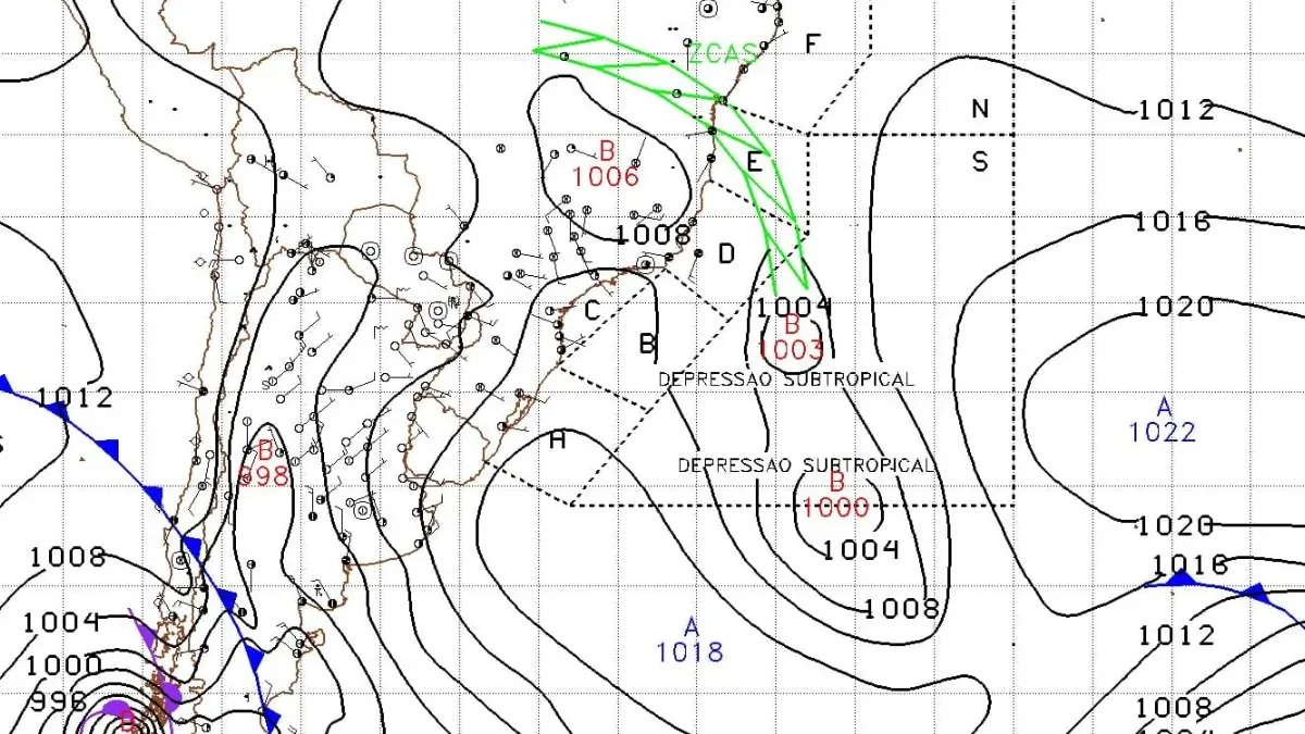
Two subtropical depressions in South Atlantic Ocean documented by Brazilian Navy on March 2, 2026. Credit: Brazilian Navy
Subtropical Storm Caiobá formed off Brazil’s southern coast on March 2, and was classified as a subtropical cyclone at approximately 12:00 UTC (09:00 LT) with an estimated central pressure of 1 003 hPa and sustained winds of 60 km/h (37 mph). It was moving south-southeast and away from the Brazilian coast.
Caiobá is an “atypical cyclone,” named by the Brazilian Navy, as wind speeds reached 60 km/h (37 mph). Subtropical and tropical cyclones in the South Atlantic remain rare because of strong vertical wind shear and generally cooler ocean temperatures.
Meanwhile, a second subtropical depression developed while Caiobá was still classified as a depression. According to Metsul Meteorologia and historical South Atlantic cyclone records, this is the first instance of two subtropical depressions being active simultaneously since the Brazilian Navy began formally monitoring and classifying such systems.
While operational monitoring of lows existed before that, formal classification and naming of subtropical cyclones began in 2011.


Caiobá originated from a frontal low that acquired a warm-core component while passing over the Brazil Current. The storm moved away from the Brazilian coast without any major impacts.
The Navy maintained advisories for offshore shipping routes, sea conditions as rough to very rough through March 3.
The last time a subtropical cyclone formed in this region was in December 2024, when Subtropical Storm Biguá struck the state of Rio Grande do Sul, causing at least two fatalities and widespread damage across the region.
The system reached maximum intensity with winds of up to 95 km/h and a minimum pressure of 998 hPa, classifying it as a subtropical storm. It was also the first subtropical storm to impact Rio Grande do Sul in December.
Prior to that, Subtropical Storm Yakecan stalled off the coast in 2022, setting record lows for the year and claiming two lives in Uruguay.
Meanwhile, Cyclone Catarina (2004) remains the only hurricane-strength tropical cyclone on record to have formed in the South Atlantic.

I am an Assistant Editor and Severe Weather & Science Journalist at The Watchers, specializing in real-time severe weather coverage, geophysical event reporting, and research-driven scientific analysis. You can reach me at rishav(at)watchers(.)news.
Rishav, thank you. Ocean temperature anomalies? Certainly chimes with record dullness and humidity and precipitation globally – heat from oceanic mantle flux??