
Atmospheric rivers forecast to bring heavy rain and snow to the Pacific Northwest through mid-March
Two atmospheric rivers are forecast to hit the Pacific Northwest beginning late March 10, 2026, bringing heavy rainfall to coastal areas and significant snowfall to higher elevations in Washington and Oregon. Precipitation totals of 180–380 mm (7–15 inches) are forecast in mountainous regions, with the potential for river rises and localized flooding through the week.
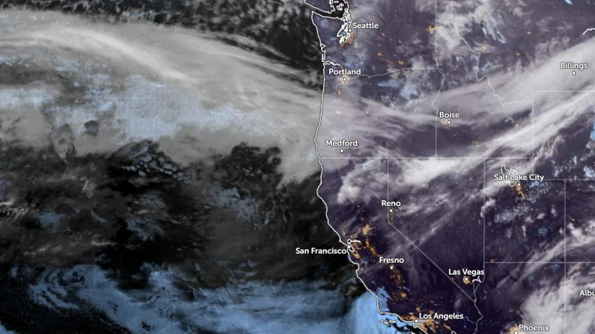
Satellite image of US West Coast at 08:50 UTC on March 10, 2026. Credit: NOAA/GOES-19, Zoom Earth,The Watchers
Two atmospheric rivers (ARs) are forecast to impact the Pacific Northwest of the United States beginning late on March 10, bringing multiple pulses of heavy precipitation and significant snowfall to Washington and Oregon.
This event will be driven by a mid-level ridge positioned west of California interacting with a broad trough over the Gulf of Alaska, establishing strong westerly flow toward the Pacific Northwest.
A plume of tropical and subtropical moisture extending northward from near Hawaii is forecast to feed into this circulation, supporting sustained moisture transport toward the region.
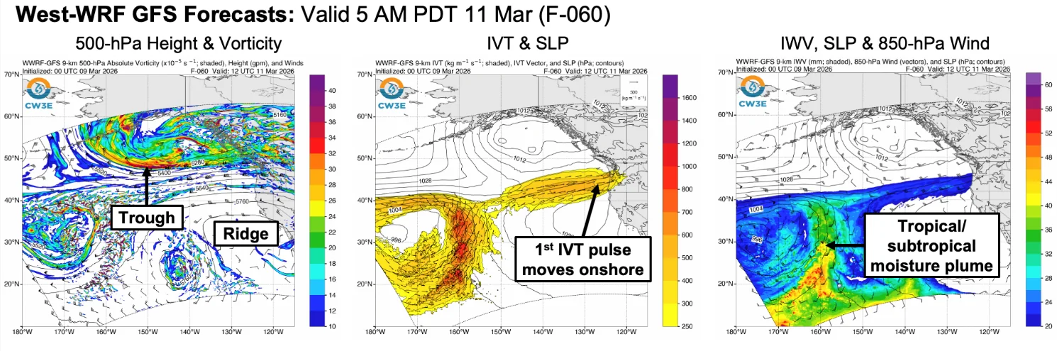
The first AR is forecast to make landfall over Oregon late March 10, delivering the initial pulse of integrated vapor transport toward the Oregon–Washington coast.
Forecast models show a 75% probability of AR3 conditions across parts of southwestern Washington and northwestern Oregon between March 11 and March 14, with IVT values of over 250 kg m-1s-1 being expected.
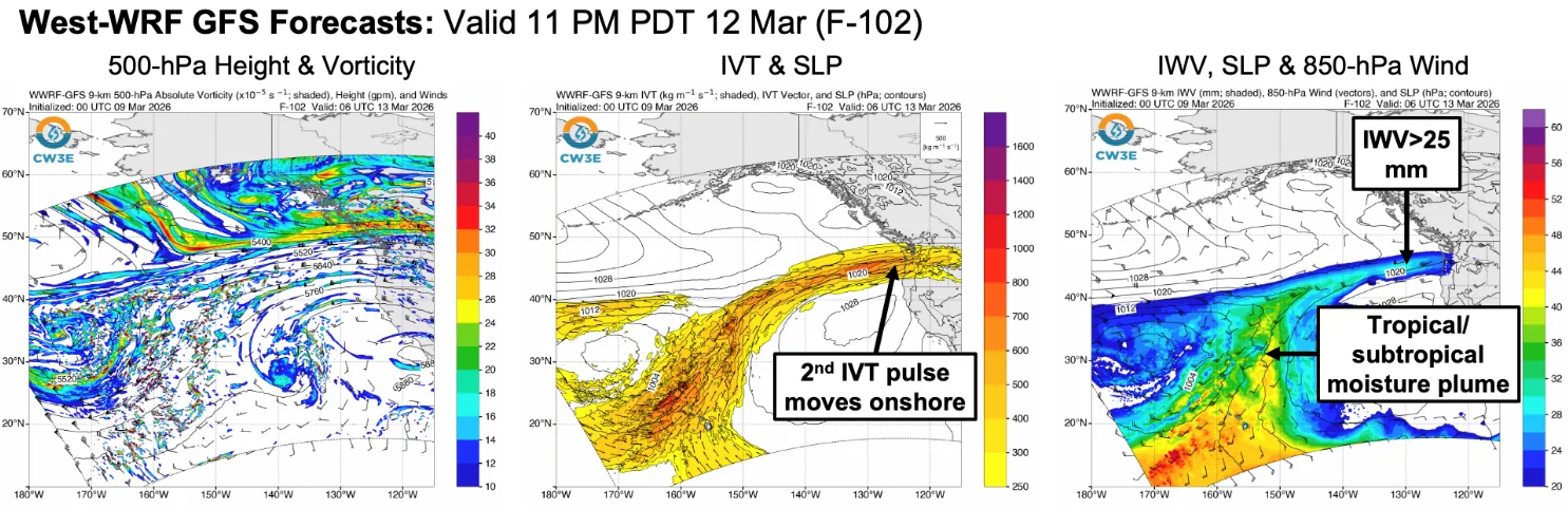
The AR will bring multiple pulses of heavy precipitation, with the first pulse being forecast to move inland after landfall on March 10. Meanwhile, the second pulse is forecast to arrive by March 12. Forecast models indicate that the second pulse will bring in the bulk of the precipitation associated with the AR.
As the first AR weakens late March 14, a second AR associated with a northward surge of tropical and subtropical moisture is forecast to approach the Pacific Northwest early March 15.
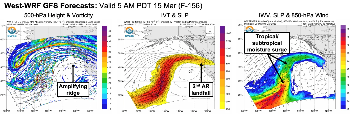
Forecast models show significant uncertainty about the exact landfall location and intensity of this second system, though AR conditions may persist between Vancouver Island and northern Oregon through March 17.
There is a possibility of continued AR conditions lasting more than 72 hours due to the second AR, while others indicate a brief weakening between the first and second AR.
180–380 mm (7-15 inches) of precipitation is forecast through the week in the Olympic Mountains, northern Oregon Coast Range, and the Washington and northern Oregon Cascades. Lower elevations across western Washington and northwestern Oregon are forecast to receive approximately 75–180 mm (3–7 inches) of precipitation during the same period.
The National Weather Service Weather Prediction Center (WPC) has issued marginal risk excessive rainfall outlooks for portions of southwestern Washington and northwestern Oregon from March 11 through early March 14 due to the potential for heavy rainfall during the first AR.
Heavy snowfall is forecast in the Olympic Mountains and Washington Cascades as freezing levels fluctuate during the event. Snowfall accumulations of over 120 cm (48 inches) above elevations of 900 m (3 000 feet) by early March 14, with higher amounts possible at elevations above 1 500 m (5 000 feet).
There is roughly a 90% probability that snowfall at Paradise in Mount Rainier National Park could exceed 180 cm (72 inches) by early March 14. The combination of heavy snow and strong winds is expected to produce moderate to major winter storm impacts in parts of the Washington Cascades.
Rivers and streams across western Washington and northwestern Oregon are expected to rise during the event due to heavy precipitation and varying freezing levels. The Northwest River Forecast Center (NFRC) expects at least four river gauges to exceed flood stage over the next ten days, while an additional 24 gauges may exceed action or bankfull levels.
References:
1 Atmospheric River Outlook – CW3E – March 9, 2026

I am an Assistant Editor and Severe Weather & Science Journalist at The Watchers, specializing in real-time severe weather coverage, geophysical event reporting, and research-driven scientific analysis. You can reach me at rishav(at)watchers(.)news.
Commenting rules and guidelines
We value the thoughts and opinions of our readers and welcome healthy discussions on our website. In order to maintain a respectful and positive community, we ask that all commenters follow these rules.