
Powerful atmospheric river hits Pacific Northwest, forecast to remain stationary over Northern California through November 22
A powerful AR4 atmospheric river made landfall in the Pacific Northwest and Northern California on November 19, 2024, bringing prolonged rainfall, heavy snowfall, and significant flooding risks that are expected to worsen through November 22. Meteorologists warn that the storm could bring up to 380 mm (15 inches) of rain to the Coast Ranges and Sierra Nevada, with some areas potentially receiving more. Higher elevations may see as much as 1.8 m (6 feet) of snow, while the Eel River and two other gauges are forecast to rise above flood stage, threatening homes and infrastructure. Residents are urged to monitor updates and prepare for dangerous travel and possible evacuation orders.

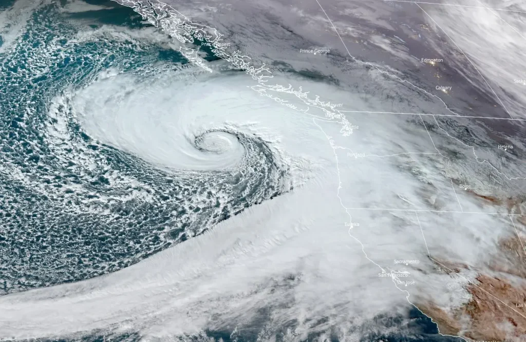
Satellite image of a rapidly intensifying cyclone off the coast of the Pacific Northwest, U.S. acquired at 22:30 UTC on November 19, 2024. Credit: NOAA/GOES-West, RAMMB/CIRA, The Watchers
- A strong, long-duration atmospheric river will bring excessive rainfall, flash flooding, and very strong winds to southwest Oregon and northwest California through Thursday. A High Risk (level 4 of 4) of Excessive Rainfall has been issued.
- The system is expected to remain stationary over Northern California through November 22, bringing prolonged rainfall, snowfall, and hydrological risks.
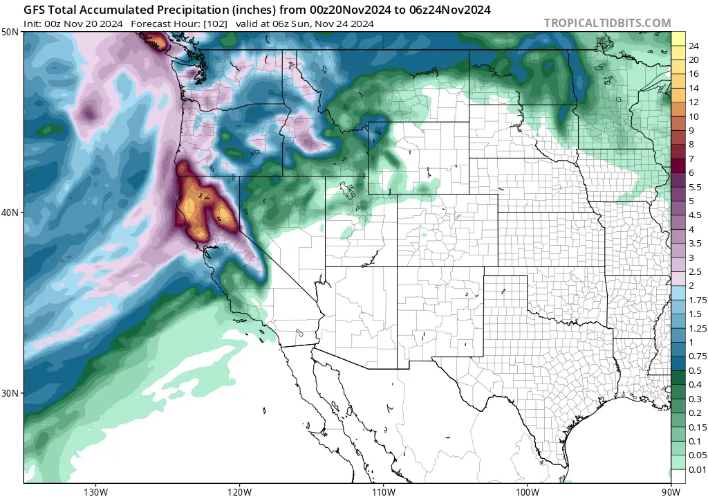
- Areas such as the Coast Ranges, Klamath Mountains, Southern Cascades, and Northern Sierra Nevada could see up to 380 mm (15 inches) of rainfall over the next five days.
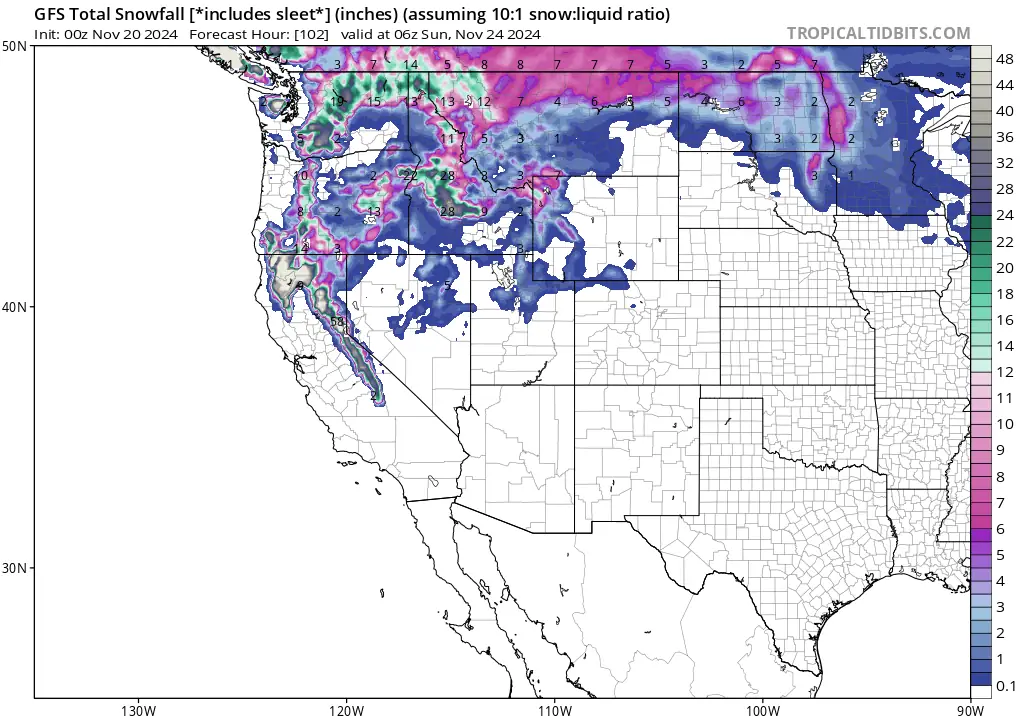
- 30 – 90 cm (12 – 36 inches) of snow is expected in the Southern Cascades and Northern Sierra Nevada, with isolated areas in the Trinity Alps receiving over 1.8 m (72 inches).
- Dangerous travel conditions are predicted in these areas, with the Winter Storm Severity Index showing an 80 – 90% probability of major impacts.
- Residents living in affected areas and visitors are urged to have multiple ways to receive warnings, listen to advice from local officials, and avoid traveling through hazardous weather conditions if possible.
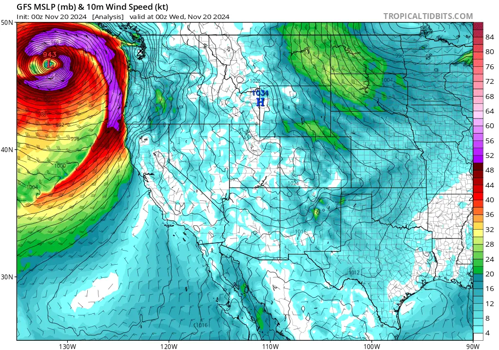
A powerful atmospheric river, categorized as AR4 on the Ralph et al. (2019) AR scale, moved ashore over the Pacific Northwest and Northern California on November 19, 2024, with moisture forecast to extend southward over the next 24 hours.
The system is expected to remain stationary over Northern California through November 22, bringing prolonged rainfall, snowfall, and hydrological risks.

As reported by the Center for Western Weather and Water Extremes (CW3E), forecasts from the GEFS and EPS models indicate a greater than 50% likelihood of AR4 conditions between the Bay Area and Eureka, California, with maximum Integrated Vapor Transport (IVT) exceeding 900 kg/m-1/s-1 for over 72 hours at 40°N, 124°W (near the California coast, around the region of Humboldt County and adjacent areas).
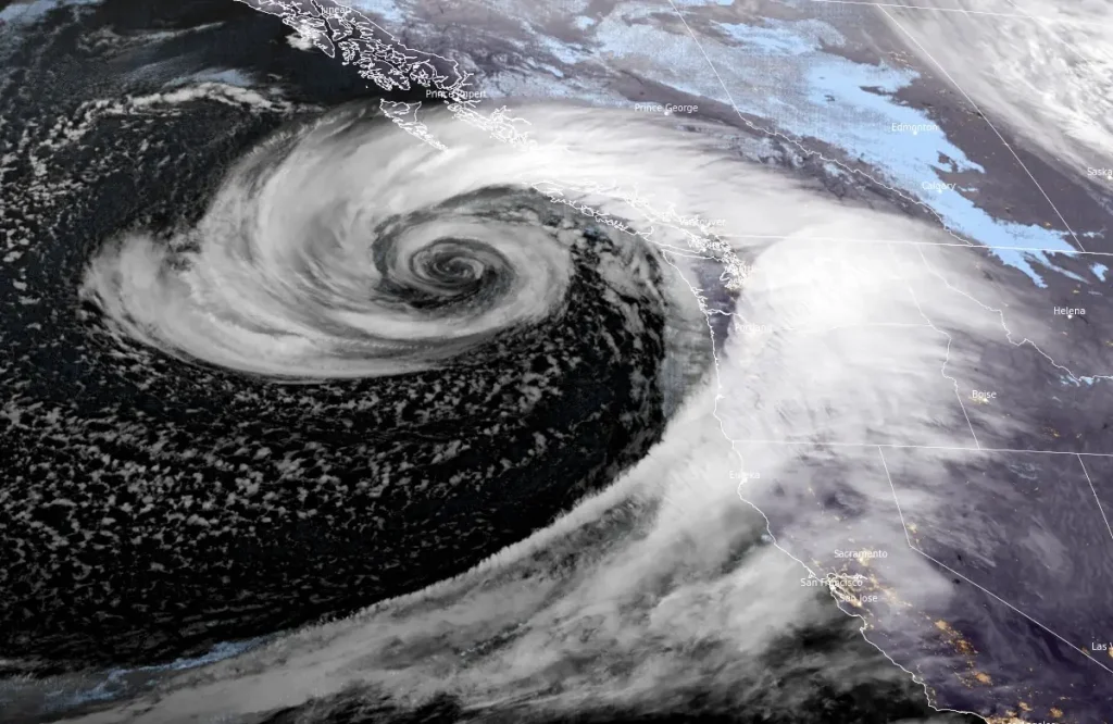
Additional strengthening of the AR is possible due to the development of a secondary low-pressure system, though the exact strength and location of this cyclogenesis remain uncertain, CW3E meteorologists said.

The National Weather Service Weather Prediction Center (NWS WPC) predicts up to 380 mm (15 inches) of rainfall in areas such as the Coast Ranges, Klamath Mountains, Southern Cascades, and Northern Sierra Nevada over the next five days.
Humboldt County faces a high risk (70%) of excessive rainfall, while a moderate risk (40%) extends to the Northern California Coast Ranges. A slight risk (15%) is expected for the Northern Sierra Nevada.
“A multi-day heavy rainfall event will impact northern California into southwestern Oregon beginning tonight, continuing into Friday as an atmospheric river stalls in and around northern California,” NWS forecaster Otto noted on November 19.
“Rainfall accumulations over 250 mm (10 inches) are likely for portions of northern California into far southwestern Oregon through Friday morning which will lead to flooding rainfall and areas of flash flooding, especially across sensitive burn scars and any urban locations,” Otto said.
WPC has issued a High Risk (level 4/4) of Excessive Rainfall across parts of northwest California on Thursday in order to further highlight the flooding threat.
Three river gauges in Northern California are projected to rise above flood stage.
The Eel River at Fernbridge is forecast to rise 6.7 m (22 feet), reaching moderate flood stage on November 22.
Meanwhile, 30 – 90 cm (12 – 36 inches) of snow is expected in the Southern Cascades and Northern Sierra Nevada, with isolated areas in the Trinity Alps receiving over 1.8 m (72 inches).
Dangerous travel conditions are predicted in these areas, with the Winter Storm Severity Index showing an 80 – 90% probability of major impacts.
“Into the mountains, heavy snow and strong winds will lead to blizzard conditions for portions of the Cascades into the northern Sierra Nevada,” Otto said, urging residents and visitors throughout the Northwest to have multiple ways to receive warnings, listen to advice from local officials, and avoid traveling through hazardous weather conditions if possible.
What is an Atmospheric River?
The American Meteorological Society (AMS) defines an Atmospheric River as a long, narrow, and temporary corridor of intense horizontal water vapor transport. They are the largest carriers of fresh water on Earth, often moving more than twice the average flow of the Amazon River.
The moisture fueling atmospheric rivers originates from tropical and extratropical sources.
When atmospheric rivers encounter obstacles such as mountains or are lifted by the warm conveyor belt of a storm system, they often produce heavy precipitation.
The term Atmospheric River was first coined in the early 1990s by scientists Yong Zhu and Reginald E. Newell.
They introduced the concept in a 1993 study to describe narrow bands of concentrated moisture transport in the atmosphere and show the significance of these features in global water vapor distribution and their role in extreme weather events.
Since then, the term has become widely adopted in meteorology and has been refined through subsequent research, including the development of scales like the Ralph et al. (2019) AR scale to categorize their intensity.
References:
1 Quick Look at the AR Forecast to Bring Heavy Rainfall to Northern California – CW3E – November 19, 2024
2 Short Range Public Discussion – NWS/WPC – November 19, 2024
3 Atmospheric River – AMS – Accessed November 20, 2024
I'm a dedicated researcher, journalist, and editor at The Watchers. With over 20 years of experience in the media industry, I specialize in hard science news, focusing on extreme weather, seismic and volcanic activity, space weather, and astronomy, including near-Earth objects and planetary defense strategies. You can reach me at teo /at/ watchers.news.
Wow. That truly is one impressive looking entity.