
1.5 million evacuating ahead of Severe Cyclonic Storm “Dana” landfall in Odisha, India
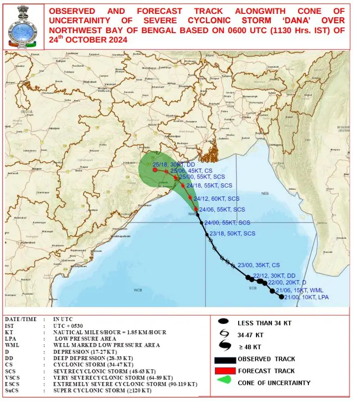
Severe Cyclonic Storm “Dana” has intensified and is expected to make landfall over the north Odisha and West Bengal coasts between Puri and Sagar Island, close to Bhitarkanika and Dhamara, between 18:00 UTC on October 24 and 00:00 UTC on October 25, 2024, with a wind speed of 100 – 110 km/h (62 – 68 mph), gusting to 120 km/h (74.6 mph).

Satellite image of Severe Cyclonic Storm "Dana" at 10:20 UTC on October 24, 2024. Credit: GEO-KOMPSAT, RAMMB/CIRA, The Watchers
- Severe Cyclonic Storm “Dana” is forecast to make landfall over the north Odisha and West Bengal coasts between Puri and Sagar Island between 18:00 UTC on October 24 and 00:00 UTC on October 25 (early hours of October 25 local time), with winds reaching up to 120 km/h (75 mph).
- A storm surge with a height of 1 – 2 m (3.3 – 6.6 feet) above the astronomical tide is highly likely to inundate low-lying areas in the Kendrapara, Bhadrak, and Balasore districts of Odisha, as well as the East Medinipur district of West Bengal.
- Additionally, a surge of 0.5 – 1 m (1.6 – 3.3 feet) above the astronomical tide is expected to inundate low-lying areas in the South 24-Parganas of West Bengal and Jagatsinghpur district in Odisha during the time of landfall.
Nearly 1.5 million people living in Dana’s expected path in Odisha and West Bengal are evacuating their homes and moving to temporary relief camps equipped with food and water.
This includes more than 1 million from 14 districts in Odisha and over 300 000 from coastal areas of West Bengal.
Dana is already affecting the region causing traffic disruptions and school cancellations. More than 200 trains and all flights from and to Bhubaneswar and Kolkata city airports have been suspended from Thursday evening to Friday morning.
Local authorities have already deployed thousands of relief workers to minimize damage.
At 09:00 UTC on October 24, the center of Severe Cyclonic Storm “Dana” was located approximately 150 km (93 miles) southeast of Paradip (population 95 000), Odisha, 180 km (112 miles) south-southeast of Dhamara (population 4 000), Odisha, and 250 km (155 miles) south of Sagar Island (population 212 037), West Bengal.
At the time, Dana had maximum sustained winds of 105 – 115 km/h (65 – 71 mph), gusting to 125 km/h (78 mph). Estimated central pressure was 984 hPa.
The system was moving north-northwestwards at a speed of 10 km/h (6.2 mph) during the past 6 hours.
Dana is expected to continue moving north-northwestwards and cross the north Odisha and West Bengal coasts between Puri (population 200 000), Odisha and Sagar Island, near Bhitarkanika and Dhamara, Odisha, between 18:00 UTC on October 24 and 00:00 UTC on October 25, 2024, as a severe cyclonic storm with a wind speed of 100 – 110 km/h (62 – 68 mph), gusting to 120 km/h (75 mph).

In the northwest Bay of Bengal, gale wind speeds reaching 105 – 115 km/h (65 – 72 mph), and gusting to 125 km/h (78 mph), are currently prevailing.
These winds are expected to gradually increase, maintaining the same speed from 12:00 UTC on October 24. In the adjoining areas of the central Bay of Bengal, wind speeds of 100 – 110 km/h (62 – 68 mph), gusting to 120 km/h (75 mph), are also present, and these are likely to continue until 12:00 UTC on October 24, decreasing thereafter. Meanwhile, in the northeast Bay of Bengal, squally winds of 50 – 60 km/h (31 – 37 mph), gusting to 70 km/h (43 mph), are expected to persist until 00:00 UTC on October 25 before subsiding.
Along the Odisha-West Bengal coasts, gale wind speeds of 60 – 70 km/h (37 – 43 mph), gusting to 80 km/h (50 mph), are already present. These are likely to increase, reaching 100 – 110 km/h (62 – 68 mph), gusting to 120 km/h (75 mph), from 12:00 UTC on October 24 until 00:00 UTC on October 25, and will gradually decrease after that.

A storm surge with a height of 1 – 2 m (3.3 – 6.6 feet) above the astronomical tide is highly likely to inundate low-lying areas in the Kendrapara, Bhadrak, and Balasore districts of Odisha, as well as the East Medinipur district of West Bengal. Additionally, a surge of 0.5 – 1 m (1.6 – 3.3 feet) above the astronomical tide is expected to inundate low-lying areas in the South 24-Parganas of West Bengal and Jagatsinghpur district in Odisha during the time of landfall.
The sea condition in the northwest Bay of Bengal is expected to remain very high until 00:00 UTC on October 25, with gradual improvement thereafter. In the central Bay of Bengal, sea conditions will be very high to high until 12:00 UTC on October 24, followed by gradual improvement.
The sea in the northeast Bay of Bengal will remain rough to very rough until 00:00 UTC on October 25 and then gradually improve. Along the Odisha-West Bengal coasts, the sea will remain high to very high until 06:00 UTC on October 25, after which conditions will gradually improve.
A total suspension of fishing operations is advised until October 25. Fishermen are strongly advised not to venture into the adjoining areas of the central Bay of Bengal until October 24, and into the northwest and adjoining northeast Bay of Bengal, including along and off the coasts of Odisha, West Bengal, and Bangladesh, until October 25.
The Indian Council of Agricultural Research (ICAR) has issued an advisory for farmers in Odisha as Dana approaches the region. The advisory includes recommendations for protecting standing crops, particularly in coastal areas, to mitigate potential damage from heavy rains and strong winds. Farmers were advised to harvest mature crops and secure harvested produce to prevent losses.
This is the 3rd named storm of the 2024 North Indian Ocean cyclone season.
References:
1 Tropical Cyclone Advisory No. 12 for the North Indian Ocean (the Bay of Bengal and Arabian Sea) – RSMC New Delhi – Issued at 12:00 UTC on October 24, 2024, based on 09:00 UTC on October 24, 2024
2 India evacuating more than a million people as Cyclone Dana nears – BBC – October 24, 2024
I'm a dedicated researcher, journalist, and editor at The Watchers. With over 20 years of experience in the media industry, I specialize in hard science news, focusing on extreme weather, seismic and volcanic activity, space weather, and astronomy, including near-Earth objects and planetary defense strategies. You can reach me at teo /at/ watchers.news.
Commenting rules and guidelines
We value the thoughts and opinions of our readers and welcome healthy discussions on our website. In order to maintain a respectful and positive community, we ask that all commenters follow these rules.