
Super Typhoon Fung-wong (Uwan) makes nighttime landfall in northern Luzon, Philippines
Super Typhoon Fung-wong (known locally as Uwan) made landfall over Dinalungan, Aurora, northern Luzon, at about 21:10 LT (13:10 UTC) on November 9, 2025, with maximum sustained winds near 185 km/h (115 mph) and gusts up to 230 km/h (143 mph). More than 1.1 million people were pre-emptively evacuated across 12 regions, and at least two fatalities and two injuries have already been confirmed.

Super Typhoon Fung-wong making landfall in Luzon, Philippines on November 9, 2025. Credit: JMA/Himawari-9, RAMMB/CIRA, The Watchers
The event comes just one week after Typhoon Kalmaegi made landfall over Guiuan, Eastern Samar, with maximum sustained winds of 150 km/h (93 mph) and gusts up to 185 km/h (115 mph). Kalmaegi brought widespread flooding and landslides across the Visayas and Bicol regions, resulting in at least 224 fatalities, 127 people reported missing, and more than 3 million affected nationwide. The back-to-back impact of Kalmaegi and the much stronger Super Typhoon Fung-wong has placed the Philippines under a national state of calamity.
Typhoon Fung-wong (local name Uwan) is a very large western North Pacific tropical cyclone that made landfall in the Philippines on November 9 after rapidly intensifying east of Luzon.
The system originated from a low-pressure area northeast of Chuuk on November 3 and was upgraded to a tropical depression and then a tropical storm by the Japan Meteorological Agency (JMA) and the Joint Typhoon Warning Center (JTWC) as it moved west-northwest over warm waters in a low-shear environment.
Tracking by the Philippine Atmospheric, Geophysical and Astronomical Services Administration (PAGASA) started on November 4, when the system was still a tropical depression far east of the Philippine Area of Responsibility. As early as the first tropical cyclone advisories, forecasts already indicated that Fung-wong could reach super typhoon intensity before landfall over northern Luzon.
On November 8 and 9, Fung-wong intensified significantly while approaching Luzon. At 14:00 LT on November 9, PAGASA reported maximum sustained winds of 185 km/h (115 mph) near the center, gusts up to 230 km/h (145 mph), a central pressure of 935 hPa, and strong to typhoon-force winds extending outward up to 900 km from the center, indicating an outer diameter of about 1 800 km (1 100 miles).
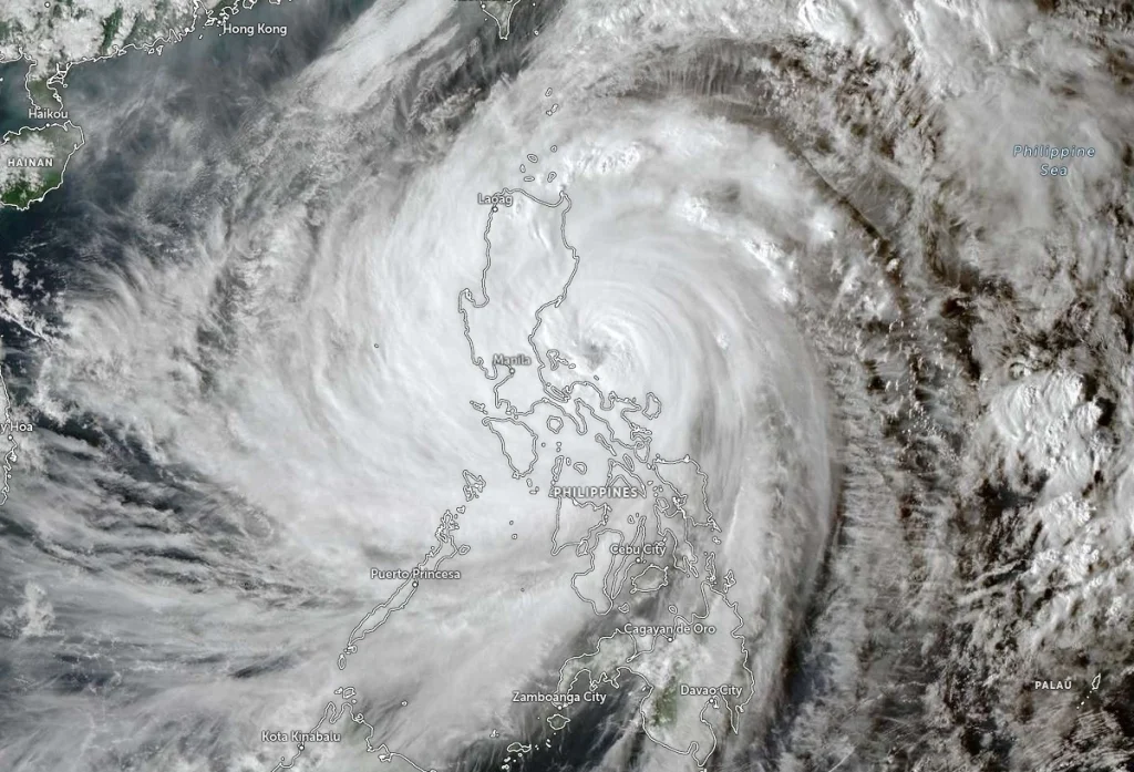
By 20:00 LT on November 9, Tropical Cyclone Bulletin No. 13 placed the eye about 125 km (78 miles) northeast of Infanta, Quezon and 85 km (53 miles) east southeast of Baler, Aurora, moving northwest at 30 km/h (18 mph) with sustained winds of 185 km/h (115 mph) and gusts up to 230 km/h (145 mph).
According to PAGASA and multiple media reports, the center of Fung-wong’s eye made landfall over Dinalungan, Aurora, in northeastern Luzon at approximately 21:10 LT (13:10 UTC) on November 9. At landfall, the cyclone was a Category 4-equivalent typhoon on the Saffir–Simpson scale, with estimated 1-minute sustained winds around 215 km/h (130 mph) and central pressure near 943 hPa.
JTWC and JMA assessments indicate that Fung-wong reached peak intensity on November 9 while approaching Luzon, with the JMA estimating 10-minute sustained winds of 155 km/h (100 mph) and the JTWC analysing 1-minute sustained winds of about 215 km/h (130 mph) and a central pressure of 943 hPa.

PAGASA upgraded Fung-wong (Uwan) to super typhoon status at 08:00 LT (00:00 UTC) on November 9, estimating 10-minute winds of 185 km/h (115 mph) and describing a circulation roughly 1 800 km (1 100 miles) in diameter.
Forecasts showed a consistent track, with Fung-wong moving west-northwestward toward the Aurora coastline, making landfall at or near its peak intensity, then traversing the mountainous terrain of northern Luzon and emerging over Lingayen Gulf or the coastal waters of Pangasinan or La Union on November 10.
Thereafter, the cyclone is forecast to turn northwest to north and then northeast toward the Taiwan Strait while gradually weakening, with a second landfall expected over western Taiwan before dissipation near the Ryukyu Islands later in the week.
PAGASA’s Tropical Cyclone Wind Signal (TCWS) system was progressively raised as Fung-wong approached Luzon. By 20:00 LT on November 9, Wind Signal No. 5 covered the northern and central parts of Aurora including San Luis, Baler, Maria Aurora, Dipaculao, Dinalungan and Casiguran, as well as portions of Quirino, Nueva Vizcaya and Nueva Ecija.
PAGASA warned of a very intense typhoon for these areas, with winds above 185 km/h (115 mph) expected within 12 hours and potential for widespread damage to structures, severe disruption of power and communications, and extensive damage to plantations and trees.
Wind Signal No. 4 is in effect over the rest of Aurora, much of Nueva Ecija, La Union, Pangasinan, Benguet, Quirino, Nueva Vizcaya, parts of Ilocos Sur, Zambales, Tarlac, Pampanga, Bulacan, Rizal and northern Quezon including Polillo Islands, indicating anticipated winds of 118–184 km/h (73–114 mph) within 12 hours and very heavy damage potential for high-risk structures.
Wind Signal No. 3 extends over southern Cagayan, the remainder of Isabela, much of the Cordillera Administrative Region, Ilocos Norte, the remainder of Ilocos Sur, the rest of Zambales, Bataan, the rest of Tarlac, Pampanga, Bulacan, Metro Manila, Cavite, Batangas, Laguna, Quezon, Marinduque, Camarines Norte, Camarines Sur and Catanduanes, where winds of 89–117 km/h (55–73 mph) were forecast.
Wind Signals No. 2 and No. 1 covered additional areas, including Batanes, Apayao, Mindoro provinces, Romblon, Masbate, including Ticao and Burias Islands, northern Palawan, including Calamian, Cuyo, and Cagayancillo Islands, and wide areas of Visayas where strong to gale-force winds and intermittent rains were expected within 24–36 hours.
PAGASA and partner agencies forecast widespread heavy to intense rainfall across eastern and northern Luzon beginning November 9, with particular concern for the Bicol Region, Aurora, Quezon and the Cordillera Administrative Region, where 24-hour totals exceeding 200 mm were considered possible. International coverage mentioned forecast rainfall of 100–200 mm (4–8 inches) or more in some regions.
Storm surge warnings indicate a high risk of life-threatening coastal flooding, with peak surges exceeding 3 m (10 feet) possible along low-lying and exposed coastal communities in Ilocos Region, Cagayan Valley, Central Luzon, Metro Manila, CALABARZON, Bicol Region, most of MIMAROPA, Northern Samar, Eastern Samar, Aklan, Antique, Guimaras, Negros Occidental, Negros Oriental, Dinagat Islands, Siargao and Bucas Grande Islands, and much of Zamboanga Peninsula.

Local reports documented coastal flooding and wave overtopping along Baybay Boulevard in Borongan, Eastern Samar, as Fung-wong’s outer circulation combined with high tide.
Marine warnings covered nearly all Philippine coastal waters. In the 24-hour sea condition outlook attached to Bulletin No. 13, PAGASA described very rough to high or very high seas with significant wave heights up to 14 m (46 feet) along the seaboards of Isabela, Aurora and Camarines Norte, up to 12 m (39 feet) off Camarines Sur and Catanduanes, and 8–10 m (26–33 feet) along parts of La Union, Pangasinan and eastern Cagayan.
Seas of 5.5–7 m (18–23 feet) were forecast along Batanes, Zambales, Albay, Sorsogon and other sectors, while even more sheltered areas in Visayas and Mindanao were expected to see 3–5.5 m (9.8–18 feet) waves. PAGASA advised that sea travel was risky or very dangerous for all vessels.
The Philippine Institute of Volcanology and Seismology (PHIVOLCS) issued lahar flow advisories for the Bicol Region, particularly on the slopes of Mayon volcano, warning that intense rainfall from Fung-wong’s rainbands could remobilize volcanic debris and produce hazardous lahars in downstream channels.

Fung-wong affected the Philippines one week after Typhoon Kalmaegi (Tino in the Philippines), which caused extensive flooding and damage across the Visayas and other regions. Early reports indicated that Kalmaegi killed at least 114 people and left 127 missing, with later tallies raising the death toll to about 224 fatalities and more than 3 million people affected.
In response to Kalmaegi and the expected threat from Fung-wong, the Philippine government declared a national state of calamity on November 6. The declaration was intended both to accelerate recovery for Kalmaegi and to enable pre-emptive measures ahead of Fung-wong.
Preparations for Fung-wong started while the disaster response to Kalmaegi was ongoing. The Department of the Interior and Local Government called on local governments to begin pre-emptive actions, and the Philippine National Police activated disaster response teams.
PAGASA briefings warned about the storm’s very large circulation, with an estimated diameter of about 1 800 km (1 100 miles) and gale- to typhoon-force winds extending hundreds of kilometers from the center.
As early as November 7, sea travel was suspended on multiple routes, with trips canceled across eastern and central Philippines as Wind Signal No. 1 was raised along the eastern seaboard and later upgraded. Airline operators adjusted schedules and canceled flights at airports including Bicol International Airport and Ninoy Aquino International Airport as Fung-wong approached.
The Department of Health went on heightened alert and prepositioned essential medicines and health supplies across Luzon. The Department of Social Welfare and Development prepared about 2 040 000 family food packs, 91 101 ready-to-eat food packs and 314 000 non-food items for possible evacuees. Malls across Luzon announced waiving overnight parking fees and opening their facilities as temporary shelters, including branches of SM, Robinsons, Megaworld, and selected Ayala, WalterMart and Vista malls.
By November 8, disaster alertness was raised to Red alert in Metro Manila, Cagayan Valley, CALABARZON, Aurora and Northern Samar, and by the end of that day the National Disaster Risk Reduction and Management Council placed the entire country under red alert. The National Telecommunications Commission mobilized regional offices and backup communications systems to support emergency services and volunteer radio and civic communication groups.
The DILG urged about 17 000 barangays nationwide to implement pre-emptive evacuations in areas at high risk of flooding and landslides starting November 8. By November 9, more than 1.1 million people across Luzon and Visayas had been evacuated to safer locations, and approximately 6 600 passengers, crew and cargo staff in 86 ports were stranded as the Philippine Coast Guard suspended sea travel and went on full alert.
Classes at all levels were suspended on November 10 and 11 across all regions of Luzon and Visayas, and government work was suspended across Luzon and Eastern Visayas. In Metro Manila, the road number coding scheme was also suspended on November 10 to facilitate movement and evacuations.
As Fung-wong’s circulation reached the Philippine landmass, heavy rainfall and strong winds affected eastern Luzon and Bicol before the Aurora landfall. By November 9, officials reported at least two storm-related fatalities — one person drowned in Catanduanes and another was killed after being trapped under debris in Catbalogan, Samar. Two injuries were reported in Catanduanes and Calinog.
Reports indicated that more than 1 million people sought refuge in evacuation centers or with relatives. Power utilities reported outages affecting at least 184 000 customers in parts of Luzon, including the Bicol region and some sections of Metro Manila. Portions of Manila’s MRT Line 3 suspended operations as strong winds and rain affected systems, and local authorities reported flooding in parts of Bicol and Eastern Visayas as rainbands from Fung-wong moved across the archipelago.
Storm surge and wave action produced coastal flooding along segments of Eastern Samar, Northern Samar and other exposed eastern coasts. Flooding was documented along Baybay Boulevard in Borongan, Eastern Samar, where water overtopped coastal defenses and entered low-lying road sections and nearby structures.
Hydrological managers opened spillways at several dams in Luzon as a precaution ahead of peak inflows, aiming to reduce the risk of uncontrolled overtopping during the main phase of the event.

Forecast guidance from JTWC and global models indicated that after crossing Luzon, typhoon Fung-wong would continue moving northwestward across the South China Sea before curving north toward Taiwan. Model consensus showed a generally steady track, although differences remained regarding its exact interaction with Taiwan.
The European Centre for Medium-Range Weather Forecasts (ECMWF) deterministic and ensemble members shifted slightly westward in their late November 9 runs, showing the system passing through the Taiwan Strait and brushing northern Taiwan, rather than crossing the island’s central portion as previously projected.
The Global Forecast System (GFS) and the United Kingdom Met Office (UKMO) models maintained a track making landfall over western Taiwan after approximately 72 hours from the forecast reference time, equivalent to around November 12.
The JTWC forecast track followed the multi-model consensus with medium confidence, forecasting Fung-wong to weaken gradually as it traverses northern Luzon but to remain a strong typhoon while crossing the South China Sea.
High-resolution dynamical models such as HAFS-A, GFS, and HWRF continue to depict a short-term reintensification while the cyclone remained over the South China Sea, attributed to increased upper-level divergence and slightly reduced vertical wind shear.
Based on the JTWC forecast, Fung-wong is expected to approach the vicinity of Taiwan around November 12–13, with peak sustained winds still within typhoon range before making landfall either along the island’s western coast or clipping its northern tip.
Beyond that, the cyclone is expected to weaken rapidly while moving northeast toward the Ryukyu Islands, where dynamical and statistical-dynamical guidance suggested dissipation of the low-level circulation later in the forecast period.
References:
1 Super Typhoon “Uwan” Bulletin #13 – PAGASA – November 9, 2025
2 Typhoon 32W (Fung-wong) Warning #22 – JTWC – November 9, 2025
I'm a dedicated researcher, journalist, and editor at The Watchers. With over 20 years of experience in the media industry, I specialize in hard science news, focusing on extreme weather, seismic and volcanic activity, space weather, and astronomy, including near-Earth objects and planetary defense strategies. You can reach me at teo /at/ watchers.news.
Commenting rules and guidelines
We value the thoughts and opinions of our readers and welcome healthy discussions on our website. In order to maintain a respectful and positive community, we ask that all commenters follow these rules.