
Typhoon Mekkhala forecast to strengthen east of northern Luzon as monsoon hazards increase
Typhoon Mekkhala, locally named Francisco in the Philippines, intensified into a typhoon east of Luzon on Sunday, June 21, 2026, and is forecast to strengthen to 165 km/h (103 mph) while tracking west-northwestward across the Philippine Sea, according to PAGASA and the Joint Typhoon Warning Center (JTWC).
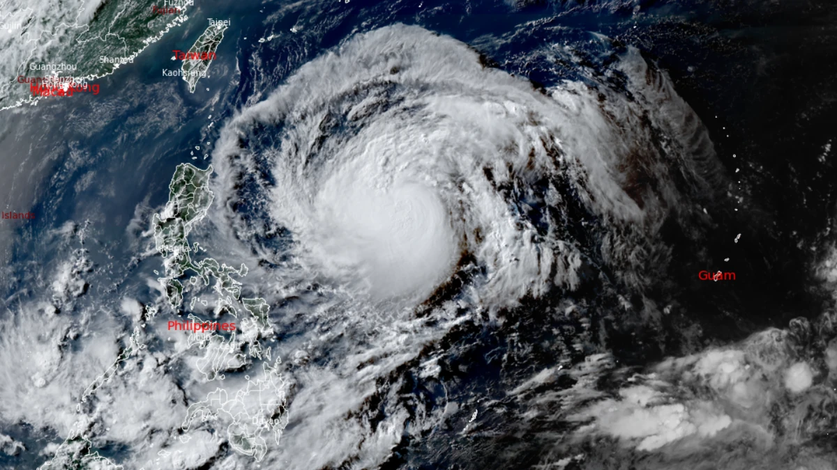
Satellite image of Typhoon Mekkhala at 08:40 UTC on June 21, 2026. Credit: JMA/Himawari-9, RAMMB/CIRA, The Watchers
Typhoon Mekkhala (locally named Francisco in the Philippines), intensified into a typhoon east of Luzon on June 21, and is forecast to strengthen further over the Philippine Sea during the next two days, according to PAGASA and the Joint Typhoon Warning Center (JTWC).
Francisco was located approximately 1 055 km (655 miles) east of Central Luzon at 16:00 LT (08:00 UTC) on June 21, PAGASA reported. 10-minute maximum sustained winds reached 120 km/h (75 mph), with gusts of up to 150 km/h (93 mph). It had an estimated central pressure of 975 hPa, and was moving west-northwestward at 25 km/h (16 mph). Strong to typhoon-force winds extended up to 420 km (261 miles) from the center.
PAGSASA forecasts continued strengthening as the system tracks across the Philippine Sea. Maximum sustained winds are expected to increase to 150 km/h (93 mph) by 14:00 LT (06:00 UTC) on June 22 before reaching a forecast peak of 165 km/h (103 mph) on June 23.
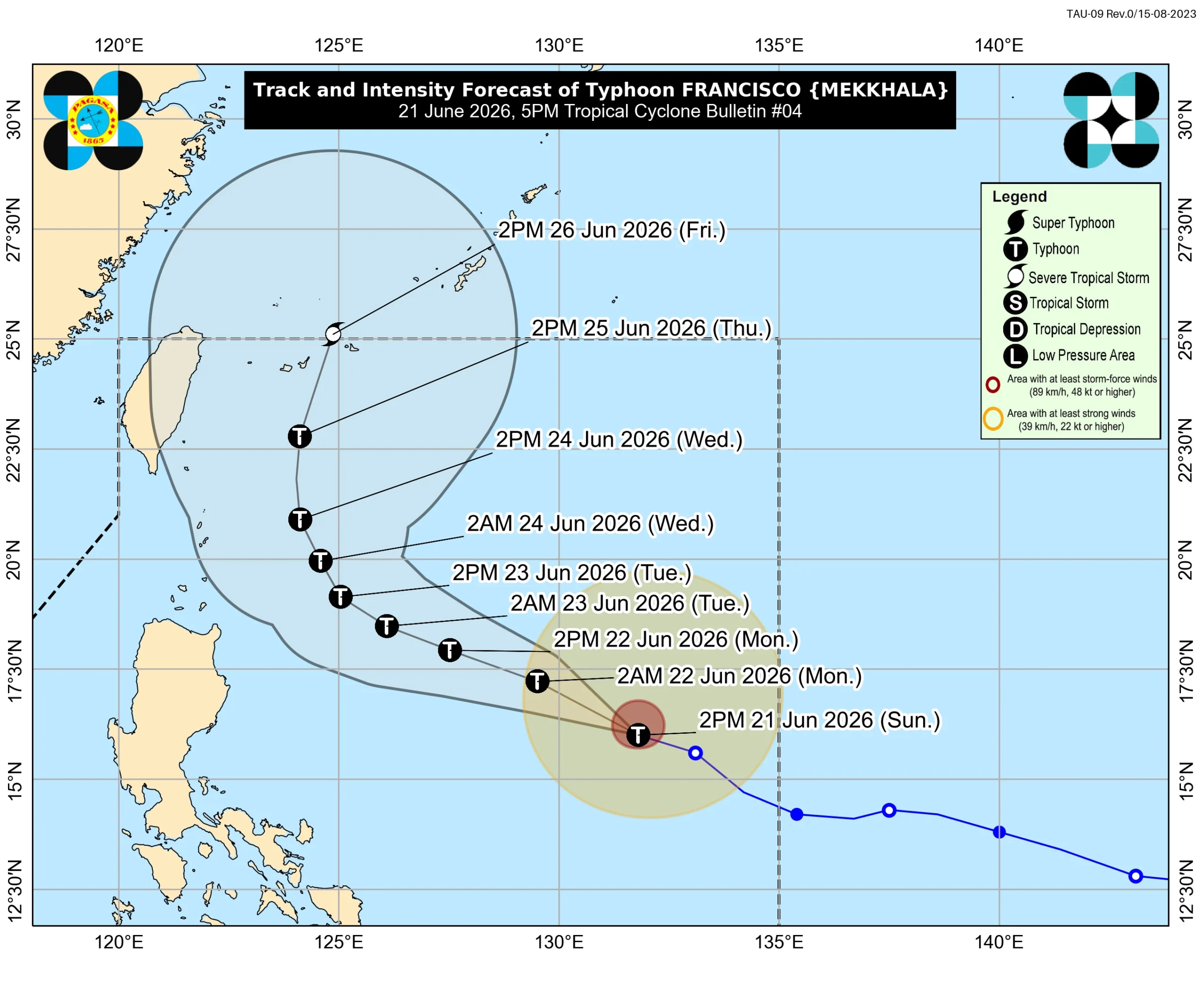
By Tuesday afternoon, the center is forecast to be about 370 km (230 miles) east of Calayan, Cagayan, after passing roughly 610 km (380 miles) east of Tuguegarao City, Cagayan, on June 22.
PAGASA expects Mekkhala to continue moving west-northwestward through June 24 before slowing and recurving toward southern Japan later in the forecast period.
The agency said the cyclone will likely remain over the Philippine Sea throughout the forecast period, although a closer approach to extreme Northern Luzon remains possible if the forecast track shifts farther west. After reaching peak intensity around June 23, gradual weakening is expected.
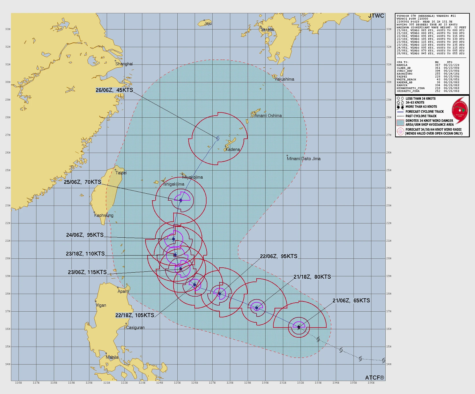
JTWC assessed the environment surrounding Mekkhala as highly favorable for intensification. Animated multispectral satellite imagery showed strong radial outflow, well-defined spiral bands of deep convection, and a symmetrical central dense overcast. Environmental conditions included low vertical wind shear of 19 to 28 km/h (12 to 17 mph), sea-surface temperatures of 29 to 30°C (84 to 86°F), and strong upper-level outflow aided by a point source aloft.
According to JTWC, Mekkhala is forecast to continue moving northwestward during the next 36 hours while remaining along the southern periphery of a subtropical ridge centered to the north.
The agency forecasts rapid intensification during the next 24 hours, followed by additional strengthening through approximately 48 hours before increasing vertical wind shear of 56 to 74 km/h (35 to 46 mph) and significantly drier air trigger a weakening trend later in the forecast period.
No Tropical Cyclone Wind Signals (TCWS) were in effect as of PAGASA’s 17:00 LT (09:00 UTC) bulletin on June 21. However, the agency said TCWS No. 1 may be raised by the morning of June 22 over northern and eastern portions of Cagayan, including the Babuyan Islands, as well as Batanes.
While Mekkhala is not expected to directly affect weather conditions over the Philippines on June 21, PAGASA warned that the enhanced Southwest Monsoon may begin producing heavy rainfall over Northern Luzon and parts of western Luzon and the Visayas starting June 22. The agency said a Weather Advisory may be issued in anticipation of these monsoon-related rainfall impacts.
The enhanced Southwest Monsoon is also forecast to bring strong to gale-force gusts across a broad portion of the country. Areas identified by PAGASA include portions of Luzon, much of the Visayas, and sections of Mindanao, with the extent of monsoon-driven winds expected to expand through June 23.
Marine conditions are expected to deteriorate across several eastern coastal waters. PAGASA forecast wave heights reaching up to 2.5 m (8.2 feet) along the eastern seaboards of Isabela and Davao Oriental, with seas of up to 2 m (6.6 feet) forecast for several other eastern coastal areas, including parts of Cagayan, the Babuyan Islands, Catanduanes, Northern Samar, Eastern Samar, Dinagat Islands, the Siargao Island-Bucas Grande Island Group, Albay, Sorsogon, Surigao del Sur, and Davao Occidental. Mariners operating motor bancas and similarly sized vessels were advised to take precautionary measures and avoid navigation if possible under these conditions.
PAGASA’s forecast track keeps Mekkhala east of northern Luzon during the coming days before the cyclone turns northward and eventually recurves toward southern Japan. Forecast agencies expect the system to reach peak intensity on June 23 while remaining over the Philippine Sea.
References:
1 Tropical Cyclone Bulletin No. 4: Typhoon FRANCISCO (MEKKHALA) – PAGASA – June 21, 2026
2 Prognostic Reasoning for Typhoon 07W (Mekkhala), Warning No. 011 – JTWC– June 21, 2026

I am an Assistant Editor and Severe Weather & Science Journalist at The Watchers, specializing in real-time severe weather coverage, geophysical event reporting, and research-driven scientific analysis. You can reach me at rishav(at)watchers(.)news.
Commenting rules and guidelines
We value the thoughts and opinions of our readers and welcome healthy discussions on our website. In order to maintain a respectful and positive community, we ask that all commenters follow these rules.