
Haishen becomes season’s first Super Typhoon, landfall expected in South Korea
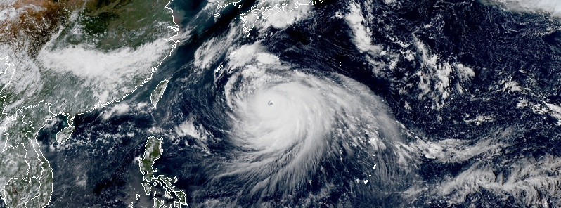
Featured image: Super Typhoon "Haishen" at 05:30 UTC on September 4, 2020. Credit: JMA/Himawari-8, RAMMB/CIRA
Typhoon "Haishen" underwent a rapid intensification phase on September 3, 2020, and became the first super typhoon of the 2020 Pacific typhoon season. The system is forecast to pass over the Ryukyu Islands, west of Kyushu, make landfall near Busan, South Korea early September 7 (UTC), and enter North Korea on the same day.
At 03:00 UTC on September 4, the center of Super Typhoon "Haishen" was located about 915 km (565 miles) southeast of Kadena Air Base, Okinawa.
Its maximum 10-minute sustained winds were 185 km/h (115 mph), maximum 1-minute sustained 250 km/h (155 mph), with gusts up to 260 km/h (160 mph). Haishen's minimum central barometric pressure was 925 hPa, and the system was moving WNW at 15 km/h (9 mph).
In 24 hours to 03:00 UTC today, Haishen intensified 50 knots (95 km/h / 60 mph), according to the JTWC.
Microwave imagery acquired at 22:00 UTC on September 3 depicts a compact eyewall, approximately 185 km (115 miles), with spiral banding over the southern semicircle.
JTWC's upper level analysis reveals a favorable environment with low vertical wind shear and radial outflow. Additionally, sea surface temperatures and high ocean heat content values are conducive for further development.
The forecast track remains highly consistent with the previous forecast and indicates a north-northwestward track over Amami Oshima then just west of Kyushu at 03:00 UTC on September 7.
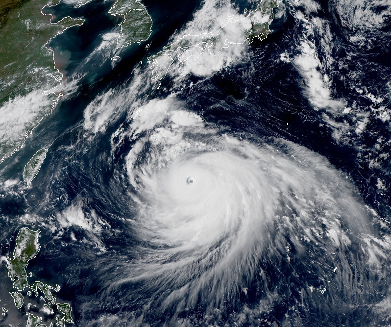
Super Typhoon "Haishen" at 05:30 UTC on September 4, 2020. Credit: JMA/Himawari-8, RAMMB/CIRA
At least one person died and more than 2 000 were displaced as powerful Typhoon "Maysak" hit Busan, South Korea on September 2, 2020. Busan is South Korea's second-largest city and the world's fifth-largest port.
The storm packed maximum sustained winds of 170 km/h (105 mph) at the time of landfall, knocking down trees and poles, flooding streets, and cutting power to nearly 280 000 homes.
Maysak is the 6th Category 2 or greater storm to lash South Korea since credible records started in 1951, and the 4th typhoon to hit the Korean Peninsula in the 2020 Pacific typhoon season. It also set a low-pressure record for South Korea at 950 hPa.
Since Tuesday, September 1, Jeju recorded 1 000 mm (39 inches) of rainfall.
More than 950 domestic flights were canceled, while some rail services were disrupted for safety purposes.
Typhoon "Maysak" at 15:30 UTC on September 2, 2020. Credit: JMA/Himawari-8, RAMMB/CIRA
I'm a dedicated researcher, journalist, and editor at The Watchers. With over 20 years of experience in the media industry, I specialize in hard science news, focusing on extreme weather, seismic and volcanic activity, space weather, and astronomy, including near-Earth objects and planetary defense strategies. You can reach me at teo /at/ watchers.news.
Commenting rules and guidelines
We value the thoughts and opinions of our readers and welcome healthy discussions on our website. In order to maintain a respectful and positive community, we ask that all commenters follow these rules.