
Records tumble as cold blast sweeps across Australia
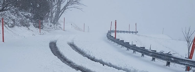
Image credit: Anthony Sharwood
A cold front is sweeping across Australia following its fifth warmest April on record, the Bureau of Meteorology (BOM) said. Parts of Victoria are set to experience their coldest start to May; New South Wales is being hit with blizzard conditions and below-freezing temperatures; Sydney had seen its coldest May 1 in a decade; parts of Southern Queensland and Brisbane shiver through near-frigid temperatures and Perth is set to be drenched by rains following the state's record-breaking April heat.
A cold front originating from Antarctica is sweeping across Australia, with states in the southeast set to see their coldest start to May. The wintry conditions came after the country recorded its fifth warmest April on record, according to the BOM's monthly review.
"'At the moment, we have a very cold outbreak across the southeast from well south of the country from the Antarctic," said Dean Narramore from the BOM. "It's one of those cases where all of the ingredients are coming together for a very cold outbreak."
New South Wales, Victoria, Tasmania, ACT, South Australia, and Queensland already experienced cool temperatures on Friday morning, May 1, 2020, and forecasts indicate that it will get even colder over the coming week. Narramore noted that northern Queensland and the Top End may still be hot but they will be 2 to 6 °C (3.6 to 10.8 °F).
In Victoria, residents woke up to the coldest start to May ever recorded, with the mercury pummeling to -4 °C (34.8 °F) in some areas. Mount Hotham experienced blizzards amid the coldest temperature at -4 °(34.8°F), which felt like -6.5 °C (20.3 °F). By the weekend, blizzard conditions are expected to continue in the state's Alpine region, with up to 50 cm (20 inches) of snow.
State capital Melbourne, which recently recorded its wettest April in 60 years, is on track to experience its coldest ever start to May if temperatures do not surpass 12.1 °C (53.8 °F). The city is currently at 12 °C (53.6 °F) but reportedly feels like 7 °C (44.6 °F) due to rainfall. The area is forecast to experience 13 and 14 °C (55.4 and 57.2 °F) over the weekend, May 2 and 3, respectively.
"Some of the temperatures are 4 to 10 °C (7.2 to 18 °F) below the May average. It's more typical of July in the middle of winter rather than May," said Narramore.
#Melbourne has experienced its wettest first 4 months of the year on record – 409.6 mm to May 1st. Previous was 1924 which had 408.8 mm Jan-Apr. pic.twitter.com/AV1jSI9l2d
— Bureau of Meteorology, Victoria (@BOM_Vic) May 1, 2020
The #snow continues at #Hotham 50cm of new #snowfall and it’s still #snowing! #coldsnap @Melbourne #melbourneweather #blizzard pic.twitter.com/USnVYRaj8J
— Hotham (@_hotham) May 1, 2020
An Autumn cold snap has blasted Melbourne – bringing rain, hail and even snow on the first day of May. @_StephAnderson #melbweather #9News pic.twitter.com/4uarswMqhR
— Nine News Melbourne (@9NewsMelb) May 1, 2020
New South Wales' capital Sydney shivered through its coldest start to May in a decade, with temperatures hitting 8 °C (14.4 °F) and a maximum of 17 °C (30.6 °F). The city will feel chilly mornings at 11 °C (51.8 °F) over the weekend but will warm up at 19 and 20 °C (66.2 and 68 °F) on Saturday and Sunday, respectively.
Up to 12 cm (5 inches) of snow is expected to fall in Thredbo, with a maximum temperature of -3 °C (26.6 °F).
The cold and windy weather has also brought early, heavy #snowfalls to the #NSW Alps and Brindabella Range west of Canberra. Heavy snowfalls are expected to continue overnight Friday and ease on Saturday.
Alpine forecast: https://t.co/OX7ZWruSq1
Video courtesy #Thredbo Resort pic.twitter.com/bLtmkMwsAx— Bureau of Meteorology, New South Wales (@BOM_NSW) May 1, 2020
Rug up for a chilly, windy day in NSW with a gusty shower or two across the southern and central ranges, adjacent slopes and southern inland, falling as snow on the southern and higher central ranges.
Forecast: https://t.co/k8NkhvlvmF
Photo: Perisher Valley courtesy Steve Smith pic.twitter.com/czaDWyMWUz— Bureau of Meteorology, New South Wales (@BOM_NSW) April 30, 2020
In southeast Queensland, some areas quivered through their coldest in 30 years. The mercury hit 5.1 °C (41.2 °F) in the town of Applethorpe on the Southern Down. State capital Brisbane's temperature fell to 14 °C (57.2 °F) on Friday. The city will further experience cold weather over the weekend, with minimum temperatures of 10 °C (50 °F) and a max of 24 °C (75.2 °F).
Meanwhile, in Western Australia, temperatures are warming up again after the cold front has moved to the country's south. "It clipped Western Australia and amplified before moving into Southern Australia," Narramore stated. "Now that the front has passed, WA will bounce back to 8 to 10 °C (14.4 to 18 °F) above average over the next week. It will basically be hot in the west, and cold in the east.
The weather in Perth turned from a record-breaking April heat to a cold snap as the state capital mark the beginning of May. The weekend will be warm and dry before pre-frontal showers form late Sunday. "It's all about to change, so enjoy the sunny weekend that we have ahead," said BOM forecaster Jessica Lingard.
"We expect some rain to come through either late Sunday night or early Monday morning, then we have a cold front coming on Monday afternoon, and a second front on Tuesday which looks like it might be the slightly stronger of the two." She added, "On Monday we're looking at some squally winds, possibly quite gusty as the front moves through in the afternoon, then some showers, and for the Perth area we could get a thunderstorm, with similar conditions on Tuesday."
Enjoy the sunshine this weekend, the showers start late on Sunday and continue through next week. Latest forecast https://t.co/dISIR84CnC pic.twitter.com/dNovt0MESk
— Bureau of Meteorology, Western Australia (@BOM_WA) May 1, 2020
The country's capital Canberra recorded a minimum temperature of 4.6 (40.3 °F) and a maximum of 7.6 °C (45.7 °F). The city is forecast to warm up over the weekend, with a maximum temperature of 15 °C (59 °F) and a minimum of 2 °C (35.6 °F).
In Tasmania, people shivered through a below-freezing temperature of -2.5 °C (27.5 °F) on Friday. Hobart recorded a minimum of 8.5 °C (47.3 °F) and a maximum of 11.8 °C (53.2 °F). The cold weather in the capital is forecast to continue over the weekend with a low of 7 °C (44.6 °F) and a maximum of 11 °C (51.8 °F).
Temperatures will be 2 to 6 °C (3.6 to 10.8 °F) below average in the Top End. As the cold front travels over land, the air will begin to warm up and have less effect.
A severe weather warning is in place for South Australia's southeast and several areas in New South Wales, with damaging winds forecast through the weekend.
Early pics from this awesome autumn Aussie blizzard via this thread https://t.co/V1MQz8cQRu on @skicomau.
And for those who'll say "climate hoax!", one cold event is evidence of zip. In Sydney where I live, 2020 months have been 1.9, 0.5, 1.3 and 2.1 deg above long-term average. pic.twitter.com/fLWPcOFgj9
— Anthony Sharwood (@antsharwood) May 1, 2020
Hey Al Gore,Greenpeace Leonardo DiCaprio,Laurie David, and all the rest of you Green Freaks its snwing in the land down under what are you going to do now?