
Heavy wet snow leaves 250 000 homes without power in Nova Scotia, Canada
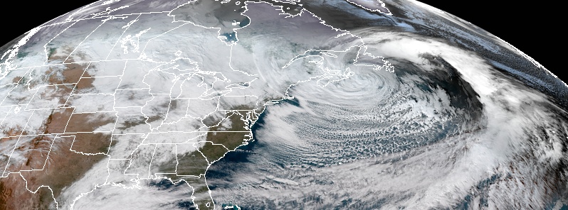
Image credit: NOAA/GOES-East. Acquired: November 29, 2018
A powerful winter storm is affecting parts of eastern Canada, causing a massive power outage in Nova Scotia, high water levels and heavy pounding surf.
At the peak of the storm, nearly 250 000 Nova Scotia Power customers were left without power, many of them in the Halifax area. It was Nova Scotia's worst power outage since Hurricane "Juan" in September 2003.
Those outages have largely been restored, but thousands are still affected from Yarmouth to central and northern Nova Scotia and into Cape Breton, CBC reports.
According to Nova Scotia Power, very heavy wet snow has dragged down power lines, weighing them down and breaking in some cases.
"We've also had trees bend over, weighed down by that heavy snow and being pushed down by high winds that have broken poles and lines," company's spokesperson Tiffany Chase said.
"A major transmission line near Port Hawkesbury was the main reason those in the Halifax area didn't have electricity. It experienced a series of cascading events that caused it to go down," she explained. "That line is sort of the backbone of the system that flows the electricity from our generating plant in Cape Breton to customers on the mainland of Nova Scotia and into Halifax metro."
Storm surges are expected in the coastal areas of northern and eastern Nova Scotia, including coastal areas of Cape Breton and the Bras d'Or Lake, Environment Canada warns.
"For north-facing coastlines, these high water levels combined with heavy pounding surf will continue to give coastal flooding until the tides recede later tonight," it said.
"Surge and waves can cause impacts well inland. Stay away from affected shorelines. People close to the shoreline should stay on the lookout for worsening conditions."
The agency said the storm would bring up to 25 cm (10 inches) of snow in northern and northeastern Nova Scotia, with lesser amounts expected for the north-facing coasts.
Winds of up to 100 km/h (62 mph) are also expected.

Teo Blašković founded The Watchers in 2011 and edited it until 2026, covering seismic and volcanic activity, extreme weather, space weather and near-Earth objects. Articles on this page are his archive.
Earlier reporting
Nothing on Watchers was published in the last 24 hours. These are older articles.
- CPC posts a slight risk of heavy rain from the Gulf Coast to the Northeast urban corridor November 25-29, and a moderate risk of West Coast wind and Sierra snow on November 25
- The storms drenching California this week are fed by a river in the sky, a band of water vapor that can carry up to 15 times the flow of the Mississippi River, and this winter’s near-record El Niño could keep aiming more of them at the West Coast
- Atmospheric river brings moderate risk of heavy rain, mountain snow and high winds to northern California and southwest Oregon on November 24-25
- 190 mm of rain and 131 km/h gusts hit New Zealand's South Island, flooding West Coast highways
