
Strengthening Polar Vortex signals return of Arctic air to North America and Europe in January 2026
Forecast models indicate the Polar Vortex will strengthen in late December 2025 after a split and disrupted phase earlier in the season. The recovery is expected to influence North American and European weather in January 2026, potentially sending colder air southward while reorganizing jet stream flow.
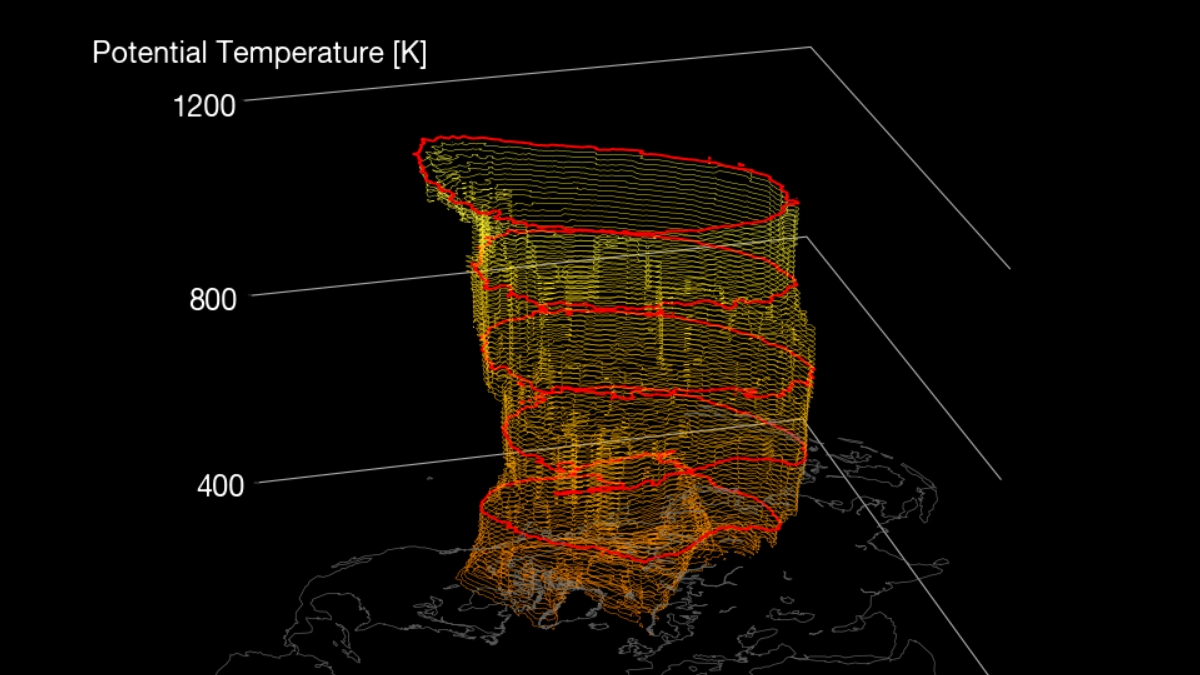
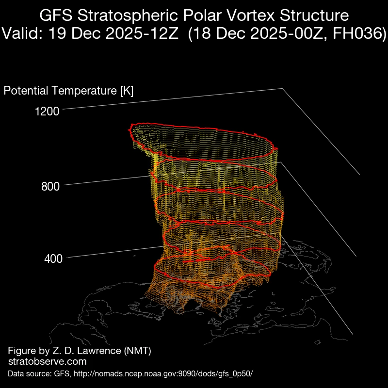
Image credit: Stratobserve
The Polar Vortex split in early December 2025, producing two distinct lobes that temporarily weakened its structure.
Extended-range forecasts now show the system consolidating into a stronger configuration through late December, suggesting a shift toward more stable Arctic containment of cold air.
The European Centre for Medium-Range Weather Forecasts (ECMWF) and other ensemble systems show that stratospheric wind speeds and geopotential height anomalies are returning toward climatological norms.
This marks the beginning of a recovery phase after weeks of vortex deformation. The stratosphere and troposphere begin to re-couple during such periods, allowing the reformed vortex to influence mid-latitude circulation patterns more directly.
The strengthening vortex could temporarily confine the coldest Arctic air near the Pole, leading to milder interludes across mid-latitudes in late December.
However, ensemble members also show that this phase will likely be short-lived, with downstream pattern adjustments allowing renewed southward movement of cold air during January 2026.
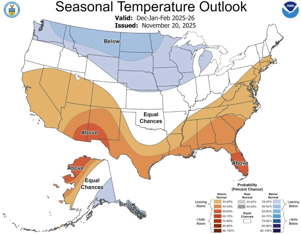
Forecasts by Climate Prediction Center (CPC) show a probability of increased storm activity along the western United States and southern Canada through the end of December, while much of Alaska and northern Canada remain under below-normal temperature anomalies.
Troughing episodes are expected to re-emerge as the vortex stabilizes, increasing the probability of Arctic air intrusions into the central and eastern United States in early to mid-January.
In Europe, forecast scenarios depict a variable pattern with alternating ridging and blocking episodes over the North Atlantic and Greenland.
A stronger Polar Vortex typically supports a more zonal jet stream, but transient blocking could still redirect cold Arctic air into northern and western Europe at times. Particularly if the Arctic Oscillation (AO) and North Atlantic Oscillation (NAO) shift toward neutral or negative phases.
The large-scale context remains influenced by weak La Niña conditions, expected to transition toward ENSO-neutral during the first quarter of 2026.
This configuration supports an active jet stream across the North Pacific and North America, modulating the interaction between tropical forcing and polar dynamics.
Read more:
References:
1 The Polar Vortex is forecast to enter a stronger phase, with Weather impacts across the Northern Hemisphere – SWE – December 19, 2025
2 NOAA’s CPC Winter 2025-26 Outlook for the Upper Mississippi River Valley – NOAA/CPC – November 20, 2025

I am an Assistant Editor and Severe Weather & Science Journalist at The Watchers, specializing in real-time severe weather coverage, geophysical event reporting, and research-driven scientific analysis. You can reach me at rishav(at)watchers(.)news.
Commenting rules and guidelines
We value the thoughts and opinions of our readers and welcome healthy discussions on our website. In order to maintain a respectful and positive community, we ask that all commenters follow these rules.