
Major storm about to slam into South Island, New Zealand
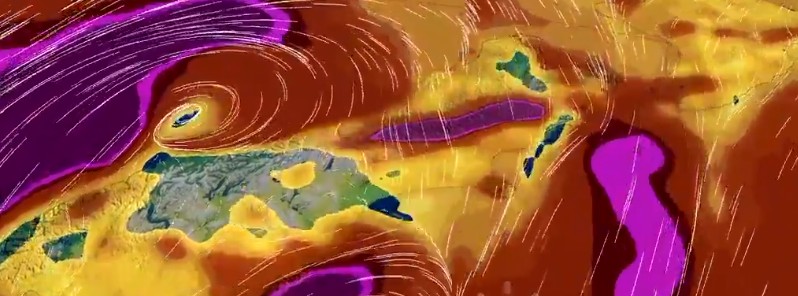
Featured image: Ex-Tropical Cylone "Fehi" wind forecast model for Thursday, February 1, 2018 at 20:00 NZDT. Credit: NIWA
What's left of former Tropical Cyclone "Fehi" is now approaching New Zealand as a major storm and is expected to hit South Island and lower parts of North Island with significant heavy rain and strong winds as it crosses the region over the next 36 hours.
While Fehi has lost most of its tropical characteristics this is still a very dangerous storm expected to bring very heavy rain and possibly damaging winds to much of the South Island and parts of the lower North Island from late Wednesday to early Friday morning (local time).
"The heaviest rain is expected in the South Island (apart from Canterbury Plains and Kaikoura Coast), especially in Westland and Fiordland where 200 to 400 mm [7.8 – 15.7 inches] of rain could accumulate from tonight to early Friday. Heavy rain is also expected for Mt Taranaki and Tararua Range," New Zealand's Met Service warns, adding that a Heavy Rain Warning is in force for these areas.
Rainfall of this intensity can cause flash flooding, especially about low-lying areas such as streams, rivers or narrow valleys, and may also lead to slips. Driving conditions will also be hazardous with surface flooding and poor visibility in heavy rain.
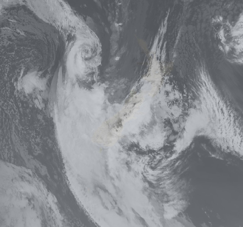
Ex-Tropical Cyclone "Fehi" at 11:00 UTC on January 31, 2018. Credit: UW-CIMMS/SSEC
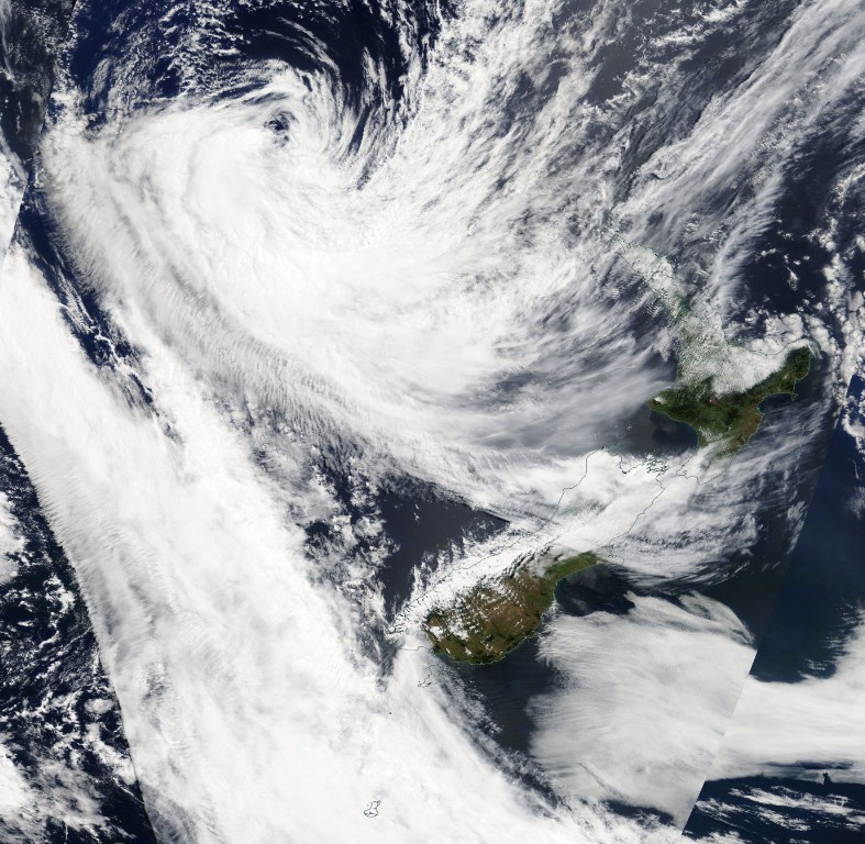
Ex-Tropical Cyclone "Fehi" on January 31, 2018. Credit: NASA Terra/MODIS
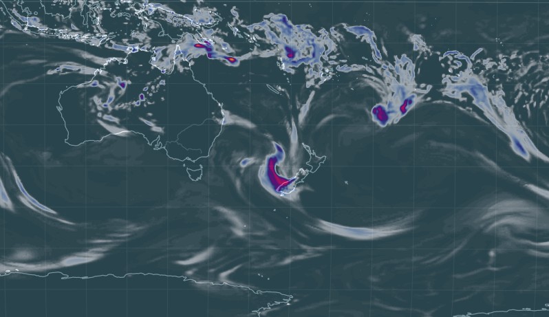
Ex-Tropical Cyclone "Fehi" 3hr rainfall accumulation ending 12:00 UTC on January 31, 2018. Credit: earth.nullschool.net
Gale force winds are expected for southern and central New Zealand, initially from the north, but turning northwest then southwest later.
The strongest winds are likely to be in Westland, Buller, Canterbury High Country, Nelson, Marlborough, Wellington and southern Taranaki, and a Strong Wind Warning is in force for these areas.
People are strongly urged to keep up to date with the latest forecasts and warnings in case other areas will be added to the Warning.
In addition, please note that the combination of strong winds, heavy swells and high tides could cause coastal inundation about the west coast of South Island and also Nelson during Thursday.
Here's a look at #CycloneFehi as it tracks into the northern Tasman Sea early Wednesday afternoon — it will interact with a front (the band of cloud approaching the South Island) and become a much stronger weather system in the next 24 hours pic.twitter.com/Rdf5hLh6k4
— NIWA Weather (@NiwaWeather) January 30, 2018
Ex-Tropical #CycloneFehi is expected to approach the West Coast early Thursday afternoon, with significant wind impacts likely
As energy from the low moves across the island, watch for strong winds to develop in eastern areas later in the day pic.twitter.com/uGMv06EbC5
— NIWA Weather (@NiwaWeather) January 31, 2018
Watching the coastal inundation/flood risk in the western South Island on Thursday afternoon — king tide for most locations falls between 12:00-1:00 pm pic.twitter.com/YKF1Qx1kWR
— NIWA Weather (@NiwaWeather) January 31, 2018
Ex-Tropical Cyclone Fehi is unlikely to make a big impact in the Waikato region. But the coincidence with King tides may cause issues over high tides on Thursday and Friday, along low-lying coastal and river areas. Keep up to date at https://t.co/4WFylmosyd. Pic from @MetService pic.twitter.com/2kLsD3lv0s
— WaikatoRegionalCounc (@ourwaikato) January 31, 2018
Severe Weather Warnings and Watches from today. For details, check here https://t.co/qHyE5zhh6X.
EDIT: to include Marlborough
^Tui pic.twitter.com/XWpEQjCNe9— MetService (@MetService) January 30, 2018
Active warnings
Note: all times NZDT, warnings valid 11:00 UTC, January 31 (01:00 NZDT, February 1)
Heavy Rain Warning
Heavy rain may cause streams and rivers to rise rapidly. Surface flooding and slips are also possible and driving conditions may be hazardous.
Area: Bay of Plenty, Rotorua, and the Gisborne ranges.
Valid: 15 hours from 3:00pm Thursday to 6:00am Friday
Forecast: Rain is forecast to set in Thursday, with heavy falls from afternoon till Friday morning. Expect 70 to 100 mm [2.7 – 3.9 inches ]of rain to accumulate, mainly about the ranges. Peak intensities of 20 to 40 mm [0.78 – 1.57 inches] per hour in possible thundery downpours.
Area: Mt Taranaki
Valid: 15 hours from 6:00am to 9:00pm Thursday
Forecast: Periods of heavy rain from Thursday morning to Thursday evening. Expect 80 to 130 mm [3.14 – 5.11 inches] of rain to accumulate. Peak intensities 25 to 35 mm [0.98 – 1.37 inches] per hour.
Area: Marlborough, Nelson and Buller
Valid: 15 hours from 3:00am to 6:00pm Thursday
Forecast: Periods of heavy rain from early Thursday morning to evening. Expect 80 to 150 mm [3.14 – 5.90 inches] of rain to accumulate, especially about the ranges. Peak intensities 25 to 35 mm [0.98 – 1.37 inches] per hour.
Area: Tararua Range
Valid: 15 hours from 12:00pm Thursday to 3:00am Friday
Forecast: Periods of heavy rain from midday Thursday to Thursday night. Expect 100 to 150 mm [3.93 – 5.90 inches] of rain to accumulate, with peak intensities of 20 to 30 mm [0.78 – 1.18 inches] per hour.
Area: Westland
Valid: 36 hours from 9:00pm Wednesday to 9:00am Friday
Forecast: Rain with heavy falls is forecast to continue till Friday morning. Expect 250 to 400 mm [9.84 – 15.74 inches] – or possibly even more – to accumulate south of Otira, and 180 to 250 mm [7.08 – 9.84 inches] farther north, especially about the ranges. Peak intensities 30 to 40 mm [1.18 – 1.57 inches] per hour.
Note, the combination of strong winds, large swells and high tides may cause inundation about the coast.
Area: Canterbury High Country within 20 km [12.4 miles] east of the divide
Valid: 35 hours from 10:00pm Wednesday to 9:00am Friday
Forecast: Periods of heavy rain are expected from late this evening till Friday morning. Expect 120 to 180 mm [4.72 – 7.08 inches] of rain to accumulate, but 200 to 300 mm [7.87 – 11.81 inches] near the divide. Peak intensities 15 to 25 mm [0.59 – 0.98 inches] per hour.
Area: Fiordland
Valid: 25 hours from 8:00pm Wednesday to 9:00pm Thursday
Forecast: Heavy rain is forecast to continue till Thursday evening. Expect a further 200 to 300 mm [7.87 – 11.8 inches] of rain to accumulate north of Doubtful Sound and 160 to 220 mm [6.29 – 8.66 inches] farther south. Peak intensities of 25 to 40 mm [0.98 – 1.57 inches] per hour.
Area: Otago
Valid: 22 hours from 2:00am Thursday to 12:00am Friday
Forecast: Rain developing tonight, with some heavy falls through to Friday morning. Expect 80 to 130 mm [3.14 – 5.11 inches] of rain to accumulate – possibly even more in the west – but 50 to 80 mm [1.96 – 3.14 inches] about North Otago. Peak intensities 15 to 30 mm [0.59 – 1.18 inches] per hour.
Area: Southland
Valid: 23 hours from 10:00pm Wednesday to 9:00pm Thursday
Forecast: Rain is forecast to become heavy this evening, continuing till late Thursday. Expect 90 to 130 mm [3.54 – 5.11 inches] of rain to accumulate. Peak intensities 10 to 25 mm [0.39 – 0.98 inches] per hour.
Strong Wind Warning
Strong wind gusts could damage trees, powerlines and unsecured structures. Driving may be hazardous, especially for high-sided vehicles and motorcycles.
Area: Southern Taranaki, Wellington, Marlborough, Nelson, Canterbury High Country
Valid: 14 hours from 3:00am to 5:00pm Thursday
Forecast: Northerly gales gusting 130 km/h [80.7 mph] or more developing overnight tonight, turning northwesterly about midday Thursday, then easing early Thursday evening.
Area: Westland and Buller
Valid: 14 hours from 3:00am to 5:00pm Thursday
Forecast: Northeasterly gales developing Thursday morning, turning northwest about midday, then turning southwest and gradually easing Thursday evening. Expect gales gusting 130 km/h [80.7 mph] or more in exposed places.
I'm a dedicated researcher, journalist, and editor at The Watchers. With over 20 years of experience in the media industry, I specialize in hard science news, focusing on extreme weather, seismic and volcanic activity, space weather, and astronomy, including near-Earth objects and planetary defense strategies. You can reach me at teo /at/ watchers.news.
Quote: “A big storm is going to slam into the South Island, New Zealand.”
If New Zealand wants to organize an influx of the world elite and business elite into the country, it must hire an operating ecologist.
His duties will include the elimination of the following natural situations:
First. Quotation: “Hurricanes and storms form due to pressure and temperature changes”. Reduce the destructive power of storms and hurricanes to minimum values.
The second. New Zealand, and the territory for hundreds of kilometers around it – is a heap of mountain formations emerging from the water. The law of physics: “All crystalline bodies with heating (warming), expand.” Expansion leads to catastrophic stresses at the joints. Joints are destroyed – and there is an underwater earthquake and a tsunami. This is what happened in Indonesia, when 230,000 people died. The official version of the scientists: “Joints of two lithospheric plates could not withstand the loads, collapsed – and one plate dived under the other.”
Third. Bunkers should be self sufficient: they are provided with high-quality air, water, and food for a long time.
If New Zealand requires environmentalists who are able to fully ensure the security of the elite, call – I will come.
Sincerely, developer of environmental programs, Victor Rodin. Ukraine. Khmelnitsky NPP. Tel. Kiev Star: 961336344. Addresses on the Internet: [email protected], [email protected].
— — —
Цитата: «Большой шторм собирается хлопнуть в Южный остров, Новая Зеландия».
Если Новая Зеландия хочет организовать приток в страну мировой элиты и бизнес элиты, она должна нанять действующего эколога.
В его обязанности войдёт устранение следующих природных ситуаций:
Первое. Цитата: «За счёт перепадов давлений и температур образуются ураганы и штормы». Снизить Разрушающую мощность штормов и ураганов до минимальных значений.
Второе. Новая Зеландия, и территория на сотни километров вокруг неё – это нагромождение вышедших из воды горных образований. Закон физики: «Все кристаллические тела при нагревании (потеплении), расширяются». Расширение приводит к катастрофическим напряжениям на стыках. Стыки разрушаются – и происходит подводное землетрясение и цунами. Именно такое явления произошло в Индонезии, когда погибло 230 тысяч человек. Официальная версия учёных: «Стыки двух литосферных плит не выдержали нагрузок, разрушились – и одна плита нырнула под другую».
Третье. Бункеры должны быть само достаточны: обеспечены качественным воздухом, водой, и продуктами питания на длительные сроки.
Если Новой Зеландии требуются экологи, способные полностью обеспечить безопасность элиты, зовите – я приеду.