
Tropical low devastates Western Australia’s north, drops massive rain
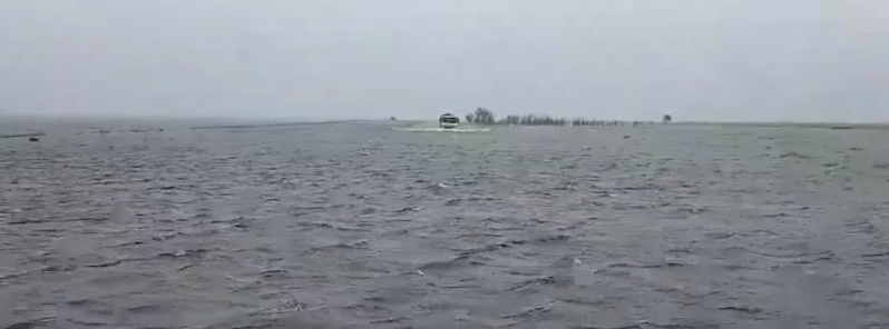
Featured image: Massive floods hit Broome region, Western Australia on January 30, 2018. Credit: Fryman KikoMan
Ex-tropical cyclones Hilda and Joyce both hit Kimberly coast, Western Australia's sparsely populated northern region in the past 35 days but an unnamed tropical low that hit the region this week exceeded both named storms in terms of rain and wind. It brought record-breaking 5-day rainfall to the region, making this January its wettest month in history. Weather authorities said the event serves as a lesson for media and residents to heed to severe weather warnings.
BOM's meteorologist Steph Bond said the conditions produced by this storm had been similar to a category one tropical cyclone. However, this weather event did not meet the criteria to be labeled a tropical cyclone.
Typically, a tropical cyclone is formed over water with sustained winds of over 120 km/h (74 mph) in the system's center. Because this tropical low did not form over water and its severe wind and rain were not in the center of the system, it did not receive a formal name.
"It is a lesson for the media and residents to pay heed to severe weather warnings," Bond said. "We have had trouble with severe weather warnings receiving less of a profile than cyclone warnings."
As reported by local media, homes and businesses have been flooded and more than 450 residents lost power as 100 km/h (62 mph) winds with gusts to 125 km/h (77 mph) uprooted trees and damaged power lines while extremely heavy rain flooded roads and homes.
Over 439 mm (17.28 inches) of rain fell within 24 hours across the Broome region on January 30. This is just short of its daily record of 476.6 mm (18.76 inches) recorded in January 1997.
As of January 30, Broome's January rainfall reached 884 mm (34.80 inches) with only 26.8 mm (1.05 inches) needed by 09:00 local time, January 31 to break the record of 910.8 mm (35.85 inches) set in 1997.
The record was broken today, with a total January rainfall of 942.2 mm (37.09 inches), BOM reported a couple of hours ago.
Broome has recorded 697.2mm in the past 5 days which is the highest 5-day total on record going back to 1889. The previous highest 5-day total was 667.4mm in 1978. Broome also received their highest monthly rainfall on record with 942.2mm! Photos: Dave Murray (Broome observer) pic.twitter.com/MOmfWlowv1
— Bureau of Meteorology, Western Australia (@BOM_WA) January 31, 2018
In addition, Broome has recorded 697.2 mm (27.44 inches) of rain in the past 5 days which is the highest 5-day total on record going back to 1889. The previous highest 5-day total was 667.4 mm (26.27 inches) recorded in 1978.
Average monthly rainfall for Broome is 183.4 mm (7.22 inches) in January and 177.4 mm (6.98 inches) in February. It's wettest February was in 1988 with 495.6 mm (19.5 inches).
Nearby West Roebuck received a whopping 1 090 mm (42.91 inches) of rain since the start of the month.
On January 30 alone, this area received 449 mm (17.67 inches) of rain and 131 mm (5.15 inches) on January 29, more than half of its record monthly rainfall in just two days.
The long-term January average for West Roebuck is only 207.3 mm (8.16 inches).
February is usually its wettest month with average long-term rainfall of 229 mm (9.01 inches) and record February rainfall of 517.6 mm (20.37 inches) set in 2007.
I'm a dedicated researcher, journalist, and editor at The Watchers. With over 20 years of experience in the media industry, I specialize in hard science news, focusing on extreme weather, seismic and volcanic activity, space weather, and astronomy, including near-Earth objects and planetary defense strategies. You can reach me at teo /at/ watchers.news.
Commenting rules and guidelines
We value the thoughts and opinions of our readers and welcome healthy discussions on our website. In order to maintain a respectful and positive community, we ask that all commenters follow these rules.