
Gaua volcano alert level raised, major unrest reported
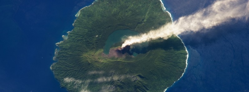
Featured image: Steam rising from Gaua volcano on May 31, 2013. Credit: NASA/ISS
The Vanuatu Meteorology and Geohazards Department (VMGD) raised the Volcanic Alert Level of Gaua volcano from Level 1 to Level 2 on January 31, 2018. The decision restricts visitors from approaching the volcanic cone. A long period of dormancy of this volcano ended in 1962 with an eruption on its SE flank. Since then, the volcano erupted 15 times, including its last eruption in 2011.
Observations performed from December 2017 to January 2018 confirm that the activity at Gaua volcano consists of ongoing volcanic steam cloud which may content volcanic gases, VGMD said today. These observations and seismic analysis confirm that the volcano activity has increased to the major unrest state.
Alert Level for Gaua volcano was at Level 1 since December 21, 2010. Based on its slight increased seismic activity and observation of ongoing volcanic gas emission and steam plumes in December 2017 and January 2018, the Volcanic Alert Level (VAL) was raised to Level 2. The current observations are consistent with the Alert Level 2 activity which indicates 'Major Unrest' – the danger is around the crater rim and specific area, there is a considerable possibility of an eruption and also a chance of a flank eruption.
VMGD advises all tourism agencies, local authorities, people of Gaua and the general public not to access Gaua's volcanic cone. In this area, volcanic gases will always be expected and other volcanic risks could occur at any time in such major unrest state. In addition, visitors approaching the volcano may smell volcanic gases.
Gaua Island is actually the exposed upper cone and summit of a stratovolcano that is 3 000 meters (10 000 feet) high and 40 kilometers (25 miles) wide. Most of the volcano is submerged beneath the Pacific Ocean.
Geological summary
The roughly 20-km-diameter (12.4 miles) Gaua Island, also known as Santa Maria, consists of a basaltic-to-andesitic stratovolcano with an 6 x 9 km (3.7 x 5.6 miles) wide summit caldera. Small parasitic vents near the caldera rim fed Pleistocene lava flows that reached the coast on several sides of the island; several littoral cones were formed where these lava flows reached the sea.
Quiet collapse that formed the roughly 700-m-deep (2 300 feet) caldera was followed by extensive ash eruptions.
Construction of the historically active cone of Mount Garat (Gharat) and other small cinder cones in the SW part of the caldera has left a crescent-shaped caldera lake. The symmetrical, flat-topped Mount Garat cone is topped by three pit craters. The onset of eruptive activity from a vent high on the SE flank in 1962 ended a long period of dormancy.

Teo Blašković founded The Watchers in 2011 and edited it until 2026, covering seismic and volcanic activity, extreme weather, space weather and near-Earth objects. Articles on this page are his archive.
Published in the last 24 hours
- In September 1859, a solar storm lit up the night sky so brightly that gold miners in the Rocky Mountains woke up after midnight and started cooking breakfast, convinced the aurora glowing over their camp was the sunrise Epicenter
- A patch of warm Pacific water that could become the strongest El Niño in more than 70 years sits thousands of miles from any American town, yet it is already the main reason NOAA expects a wetter winter across the South and a milder one across the North
- A 19-year-old Nebraska teacher reportedly tied her pupils together with twine and led them to safety through a blizzard in January 1888 Epicenter
- NASA built the Opportunity rover to last 90 days on Mars, and Martian winds helped keep it alive for nearly 15 years by blowing dust off its solar panels, until a planet-wide dust storm in 2018 blocked sunlight and silenced the rover Epicenter
