
Category 3 Tropical Cyclone “Megan” hits Gulf of Carpentaria, stranding residents of Borroloola
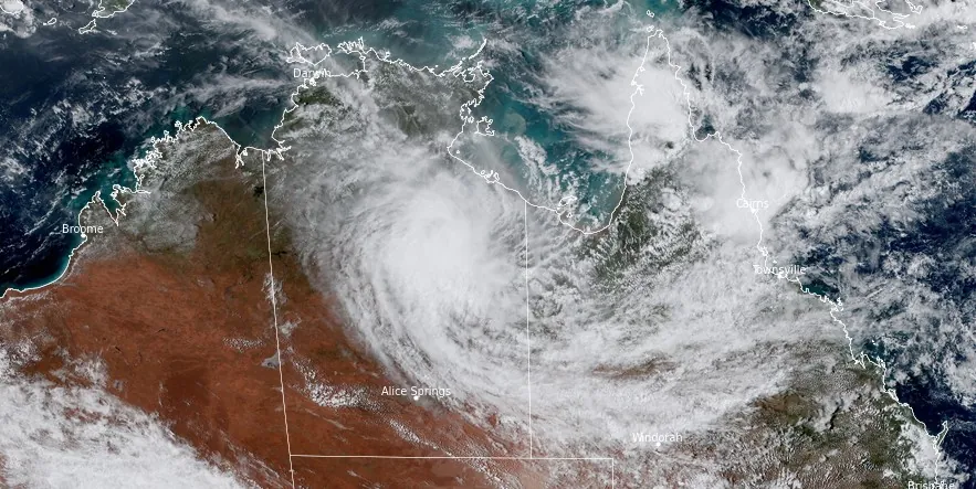
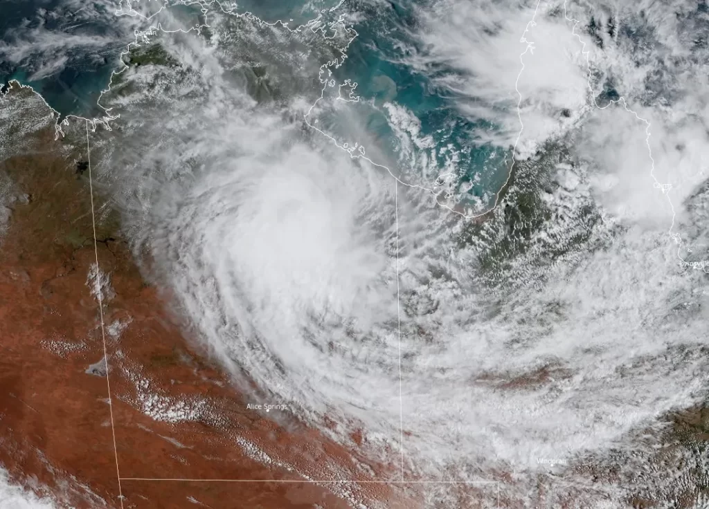
Featured image: Ex-Tropical Cyclone Megan at 05:20 UTC on March 19, 2024. Credit: JMA/Himawari-9, RAMMB/CIRA, The Watchers
Category 3 Tropical Cyclone “Megan” made landfall near Borroloola, the southwestern Gulf of Carpentaria coast, at approximately 06:00 UTC on March 18, 2024. At the time of the landfall, the system had a minimum pressure of 976.1 hPa and 1-minute sustained winds of 185 km/h (115 mph). Megan is the 5th named storm of the 2023/24 Australian region cyclone season.
After making landfall, the system moved in a southeast trajectory, passing inland of Borroloola. Although the Bureau of Meteorology (BoM) downgraded Megan to a tropical low as it neared the inland regions of the Gulf of Carpentaria, the cyclone had already inflicted considerable damage, with some communities, particularly on Groote Eylandt in the Northern Territory, experiencing up to 680 mm (26.7 inches) of rainfall in the 48 hours to Sunday morning, March 17.
Efforts were made to airlift residents of Borroloola (population 700) before landfall, but worsening weather conditions halted the operation. Local authorities confirmed the suspension of operations but reassured the community, emphasizing the availability of structures capable of withstanding a Category 3 cyclone, including the police station, health center, and numerous residential buildings.
An intended evacuation of personnel from the McArthur River Mine was also aborted due to the severe weather.
Heavy rains are still falling over the region as the system slowly moves southwest over the eastern Northern Territory.
A Major Flood Warning is currently in effect for the McArthur River and a Severe Weather Warning for heavy rainfall for districts covering the McArthur River catchment.
According to data provided by BOM, rainfall totals of up to 260 mm (10.2 inches) have been recorded across the McArthur River catchment in the 24 hours to 04:30 UTC (15:00 LT) on Tuesday, March 19. However, rain and storms with isolated heavy falls are still forecast over the next few days across the McArthur River, with 6-hourly rainfall totals between 80 and 120 mm (3.1 – 4.7 inches) likely and 24-hourly rainfall totals up to 180 mm (7 inches).
River level rises at Borroloola have been observed in response to rainfall, with water levels expected to continue rising during Tuesday and Wednesday.
At 05:04 UTC (15:33 LT) on March 19, the McArthur River at Borroloola was at 12.9 m (42.3 feet) and rising, above the minor flood level (9 m / 29.5 feet). The McArthur River at Borroloola will exceed the moderate flood level (13.7 m / 44.9 feet) on Tuesday evening (LT) and likely exceed the major flood level (14.90 m / 48.8 feet) on Wednesday morning. It may reach around 15.30 m (50.19 feet) by midday Wednesday (LT), according to BOM.
The Northern Territory Emergency Service advises people to stay away from flooded drains, rivers, streams and waterways. “Prepare for flooding and move away while it’s safe to do so.”
A Flood Watch is in effect for inland parts of NT and Carpentaria Coastal Rivers. “Catchments in the Flood Watch area are relatively wet and responsive to rainfall, and river levels remain elevated in parts of the Flood Watch area,” BOM said.
Rainfall totals of up to 264 mm (10.3 inches) were recorded across the Flood Watch over the past 24 hours and more rain is on the way, with BOM forecasting widespread totals of 60 – 150 mm (2.3 – 5.9 inches) during the next few days across the Flood Watch area. Isolated heavy falls over 200 mm (7.8 inches) are possible, with the heaviest totals likely to occur near the system center.
“The recent observed rainfall is causing flooding impacts, and with further rainfall forecast, impacts will become more widespread and severe over the coming days. Flood impacts may include road closures, including primary and secondary highways, and the isolation of communities and homesteads. Check road conditions before traveling,” BOM said.
A Moderate Flood Warning is in effect for the Daly River and a Severe Weather Warning for heavy and locally intense rainfall for parts of Carpentaria and Barkly districts. Catchments likely to be affected include: Upper Victoria River, Victoria River below Kalkarindji, Waterhouse River, Roper River, Towns River, Limmen Bight River, Rosie River, Robinson River, Calvert River, Settlement Creek, Nicholson River, Tanami Desert, Barkly, and Central Desert.
“Ex-Tropical Cyclone Megan is moving slowly southwest over the eastern Northern Territory,” BOM meteorologists said at 09:03 UTC.
The system is forecast to move west across the central Northern Territory over the next few days and dissipate as it approaches the Kimberley late in the week.
References:
1 Cyclone weakens to a tropical low while bringing rain and wind to Australia’s northern coast – AP – March 19, 2024
2 NT residents assess damage from Tropical Cyclone Megan after evacuation efforts fail – March 19, 2024
3 Tropical Cyclone Megan makes landfall on Gulf of Carpentaria, weather conditions intensify – ABC – March 18, 2024
4 Tropical Cyclone Forecast – Ex-Tropical Cyclone Megan – BOM – March 19, 2024
5 Major Flood Warning for the McArthur River – BOM – Issued at 3:33 pm CST on Tuesday 19 March 2024
6 Flood Watch for inland parts of NT and Carpentaria Coastal Rivers – BOM – Issued at 11:51 am CST on Tuesday 19 March 2024
I'm a dedicated researcher, journalist, and editor at The Watchers. With over 20 years of experience in the media industry, I specialize in hard science news, focusing on extreme weather, seismic and volcanic activity, space weather, and astronomy, including near-Earth objects and planetary defense strategies. You can reach me at teo /at/ watchers.news.
i’ll bet a lot of Americans have no idea where this is..