
Category 2 Tropical Cyclone “Kirrily” makes landfall between Townsville and Ingham, Queensland
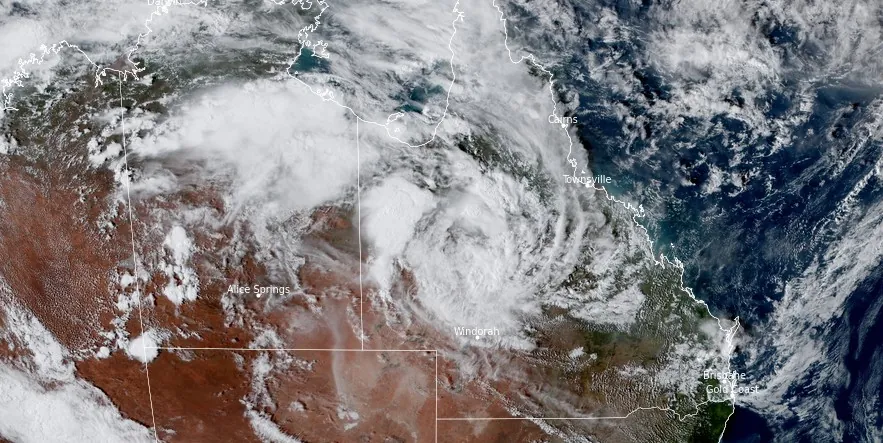
Featured image: Ex-Tropical Cyclone "Kirrily" at 06:00 UTC on January 26, 2024. Credit: JMA/Himawari-9, RAMMB/CIRA, The Watchers
Tropical Cyclone “Kirrily” made landfall in Queensland, Australia at 22:00 local time (11:00 UTC) on January 25, 2024, with maximum sustained winds of 143 km/h (89 mph) — Category 2 cyclone on the Australian scale.
Ex-Tropical Cyclone Kirrily is now moving inland across northern interior Queensland, resulting in severe weather warnings, and extensive power outages.
The Australian Bureau of Meteorology (BOM) issued a statement at 05:24 UTC today, highlighting ongoing severe weather conditions and numerous flood watches and warnings. The ex-tropical cyclone is expected to produce heavy to intense rainfall, potentially accompanied by damaging winds, in parts of the northern interior and western Queensland during the weekend.
Tropical Cyclone Kirrily crossed the Queensland coast as a category two system at 10 pm AEST, between Townsville and Ingham, and is now moving over land #CycloneKirrily
— Bureau of Meteorology, Australia (@BOM_au) January 25, 2024
Latest: https://t.co/jlOoTZL1iF or the BOM Weather app. pic.twitter.com/PRqWxJ08iA
A significant consequence of the cyclone’s passage is the widespread power outage affecting approximately 50 000 homes and businesses. The majority of these outages, around 40 000, are in Townsville, with another 9 000 in Ayr and Home Hill. The damage to trees, branches, and power lines, along with minor damage to property and infrastructure, has been reported. Repair efforts are slated to commence post-storm.
QFES Acting Commissioner Stephen Smith urged the community to exercise caution, particularly regarding potential live power lines and moving water. He expressed gratitude towards the community for adhering to safety advice, which resulted in no requirement for swift water rescues. Smith commended the community’s planning and preparation, as evidenced by the relatively low number of assistance requests (just over 170).
The Townsville Disaster Management Group has confirmed it is now safe for residents to leave their places of shelter. However, they are advised to avoid unnecessary travel and remain vigilant about cyclone-related damage, including fallen power lines.
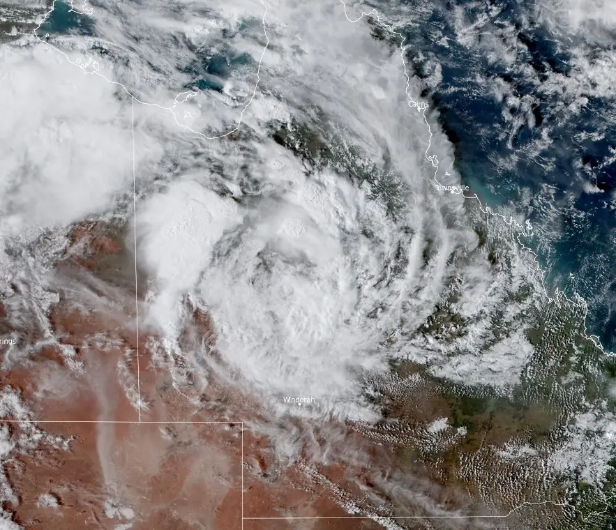
Meteorologist Angus Hines emphasized that while wind damage was the immediate concern, the focus would shift to rainfall in the coming days. The ex-tropical cyclone is expected to continue its westward trajectory, bringing significant rainfall through northern interior Queensland.
Heavy rainfall, with the potential for flash flooding, is forecasted for parts of the Northern Goldfields and Upper Flinders, North Tropical Coast, Herbert, and Lower Burdekin districts. Rainfall totals between 80 to 120 mm (3.1 – 4.7 inches) are likely over six hours, with 24-hour totals reaching up to 180 mm (7 inches), especially on the northern flank of the tropical low.
During the next week, the remnants of Ex-Tropical Cyclone Kirrily are expected to continue moving westwards across the central Northern Territory and into northern Western Australia, as a weak tropical low.
References:
1 Tropical cyclone forecast – BOM – January 26, 2024
2 Cyclone Kirrily weakens to tropical low after crossing Queensland coast – 9news – January 26, 2024
I'm a dedicated researcher, journalist, and editor at The Watchers. With over 20 years of experience in the media industry, I specialize in hard science news, focusing on extreme weather, seismic and volcanic activity, space weather, and astronomy, including near-Earth objects and planetary defense strategies. You can reach me at teo /at/ watchers.news.
Commenting rules and guidelines
We value the thoughts and opinions of our readers and welcome healthy discussions on our website. In order to maintain a respectful and positive community, we ask that all commenters follow these rules.