
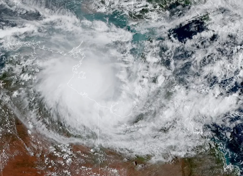
Severe Tropical Cyclone “Megan” reaches Category 3, landfall expected on March 18, Australia
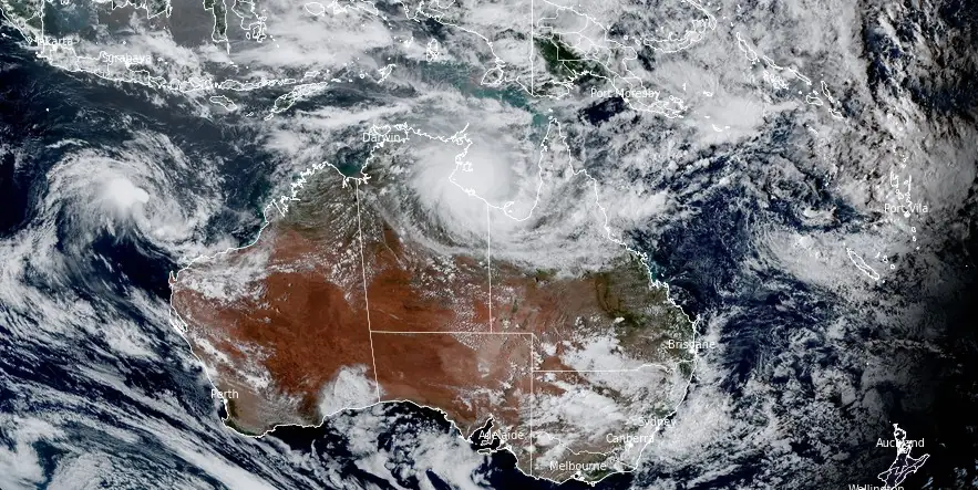
Featured image: Severe Tropical Cyclone "Megan" at 06:00 UTC on March 17, 2024. Credit: JMA/Himawari-9, RAMMB/CIRA, The Watchers
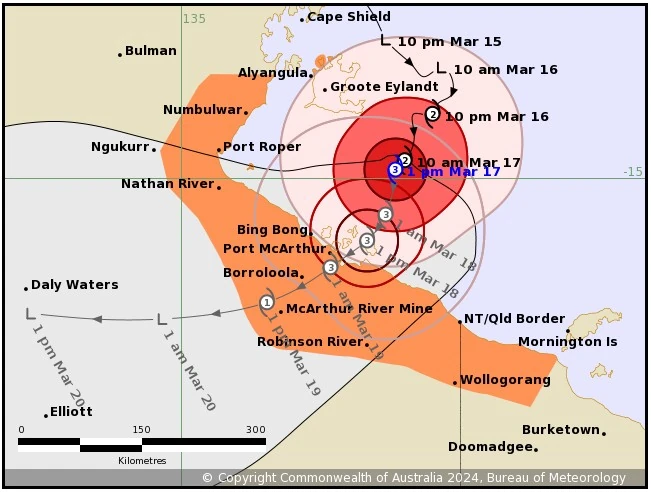
Tropical Cyclone “Megan” formed on March 16, 2024, in the Gulf of Carpentaria as the 5th named storm of the 2023/24 Australian region cyclone season. Megan has reached Category 3 intensity today and is forecast to cross the southwest coast of the Gulf of Carpentaria, most likely on Monday, March 18, with wind gusts up to 220 km/h (137 mph).
- The very destructive core of Megan, with wind gusts up to 220 km/h (137 mph), is expected to cross the coast between Nathan River in the Northern Territory and the Northern Territory/Queensland border on Monday.
- Coastal residents between Nathan River and the Northern Territory/Queensland border are specifically warned of a dangerous storm tide as the cyclone center crosses the coast. Tides are likely to rise significantly above the normal high tide, with damaging waves and dangerous flooding.
Severe Tropical Cyclone “Megan” has strengthened to a Category 3 system on the Australian Tropical Cyclone Intensity Scale. Impacts are beginning on the southwestern Gulf of Carpentaria coast, the Australia Bureau of Meteorology (BOM) said at 13:25 ACST (03:55 UTC) on March 17.
At 12:30 ACST (03:00 UTC) on March 17, the center of Severe Tropical Cyclone “Megan” was located about 150 km (93 miles) SE of Alyangula and 170 km (105 miles) NE of Borroloola. It had sustained winds of 120 km/h (75 mph) with gusts to 165 km/h (102 mph) and was moving SSW at 6 km/h (3.7 mph).
“Severe Tropical Cyclone ‘Megan’ lies to the southeast of Groote Eylandt and has strengthened to Category 3 intensity,” BOM said. “Megan has been moving slowly south-southwest, and is expected to strengthen further before crossing the southwestern Gulf of Carpentaria coast on Monday [March 18] between Nathan River and the Northern Territory/Queensland border.”
Once over land, Megan is forecast to weaken and move west across the Northern Territory as a tropical low.
Hazards
Gales with damaging wind gusts to 110 km/h (68 mph) are currently being experienced over parts of Groote Eylandt, and are expected to persist for the remainder of Sunday.
Gales with damaging wind gusts to 110 km/h (68 mph) are occurring about the Sir Edward Pellew Group. These gales are expected to extend to coastal mainland areas between Nathan River and the Northern Territory/Queensland border later this afternoon, and to inland areas including Borroloola, McArthur River Mine, and Robinson River overnight or on Monday.
Gales with damaging wind gusts to 110 km/h (68 mph) may extend further northwest to Numbulwar in the NT, or east to Mornington Island in Queensland (not including Mornington Island), during the next 24 hours if Megan moves further west or east than forecast.
Destructive wind gusts in excess of 125 km/h (78 mph) are likely to develop about the southwestern Gulf of Carpentaria coast, between Nathan River in the Northern Territory and the Northern Territory/Queensland border, from late this afternoon or overnight as Megan moves closer to the coast.
The very destructive core of Megan, with wind gusts up to 220 km/h (137 mph), is expected to cross the coast between Nathan River in the Northern Territory and the Northern Territory/Queensland border on Monday.
Intense rainfall is possible about coastal parts of the Carpentaria District as Megan approaches later today and during Monday.
Heavy rainfall is occurring over southeastern parts of the Top End, with the heaviest falls in coastal and island locations. The heaviest falls will extend further inland during today in the Carpentaria forecast district as well as into parts of the Gulf Country coast in Queensland.
Coastal residents between Nathan River and the Northern Territory/Queensland border are specifically warned of a dangerous storm tide as the cyclone center crosses the coast. Tides are likely to rise significantly above the normal high tide, with damaging waves and dangerous flooding.
Abnormally high tides are expected over remaining parts of the southern Gulf for the next few days, and will likely rise above the normal high tide at times.
Recommended action:
The Northern Territory Emergency Service advises the communities in the area of the Cyclone Warning:
- Enact your household plan
- Prepare your property now
- Stay informed
- Take extra care on the roads
QFES advises people between the Queensland/Northern Territory border and Mornington Island, not including Mornington Island, should take precautions and listen to the next advice.
References:
1 Tropical Cyclone Forecast Map for Severe Tropical Cyclone Megan – BOM – 13:25 ACST on March 17, 2024
I'm a dedicated researcher, journalist, and editor at The Watchers. With over 20 years of experience in the media industry, I specialize in hard science news, focusing on extreme weather, seismic and volcanic activity, space weather, and astronomy, including near-Earth objects and planetary defense strategies. You can reach me at teo /at/ watchers.news.
Commenting rules and guidelines
We value the thoughts and opinions of our readers and welcome healthy discussions on our website. In order to maintain a respectful and positive community, we ask that all commenters follow these rules.