
New volcanic eruption begins on Reykjanes Peninsula, Iceland
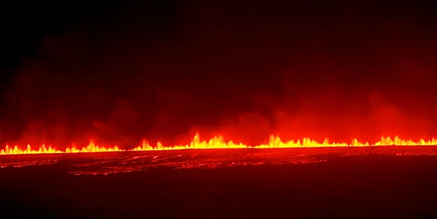
Image credit: mbl.is (stillshot)
After more than a month of magma buildup, a new eruption began in Reykjanes Peninsula, between Hagafell and Stóra-Skógfell, at 20:23 UTC on March 16, 2024.
The source of the eruption is closer to Stóra-Scógfell, in a similar place to the last eruption that occurred on February 8.
The lead-up to the eruption was short, but the Icelandic Met Office (IMO) provided many updates over the past couple of weeks that showed a new eruption is imminent.
The plume is traveling the the northwest, IMO said at 20:50 UTC.
The first location of the eruption is based on radar data. You can see it on the map below, marked by a red dot.

According to initial assessments, it seems that the same amount of magma is emerging as was measured in the eruption on February 8.
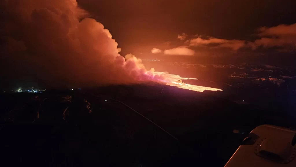
The photo below was just taken from a patrol flight by the Swedish Coast Guard. The main lava flow seems to flow to the south and east.
In an update posted at 00:50 UTC on March 17, IMO said the power of the eruption has not decreased much.
“The southern and northernmost part of the crack seems to have faded a bit. Otherwise, the entire fissure erupts fairly continuously. The lava bed that now flows over Grindavíkurveg is significantly wider than in February.”
Surveillance flight information shows the advance of the lava tongue, which flows south, has slowed down. The speed is now estimated to be around 300 m (980 feet) per hour.

Live streams of the eruption
Updates
17:27 UTC, March 17
In an update posted at 13:00 UTC today, IMO said the intensity of the eruption decreased during the night and there are now three active openings on the eruptive fissure.
Seismic activity also significantly decreased overnight, with very few earthquakes measured after 03:00 UTC, coinciding with a decrease in volcanic tremor. This development is very similar to the three previous eruptions on the Sundhnúkur crater row.
Shortly after midnight, lava flowed over the Grindavík road towards the water distribution pipe from Svartsengi power plant. There has been limited advancement in that lava flow front since this morning and it is now about 200 m (650 feet) from the pipe.
Another lava flow front runs alongside the protective barriers east of Grindavík and towards Suðurstrandarvegur road. Response workers in the area are monitoring the lava’s advance rate, which has been slow and steady since this morning.
19:00 UTC, March 18
Eruptive activity has been relatively stable since yesterday afternoon. The eruption is focused at two locations along the eruptive fissure, but the northernmost craters that were active yesterday are not active now, IMO reported at 11:45 UTC today.
The most active areas are near the southern end of eruptive fissure that opened on Saturday evening, with lava flowing from these locations southward towards the road Suðurstrandarvegur.
This morning (UTC), the lava flow was approximately 330 m (1 082 feet) from the road, with minor movement of the margin since yesterday evening. Observations of the area yesterday evening indicate that there is not significant activity or movement of the lava flow that crossed the road Grindavíkurvegur few hours after the eruption started.
The extent of the new lava is estimated to be 5.85 km2 (2.2 mi2), based on satellite imagery acquired at 14:56 UTC on March 17.

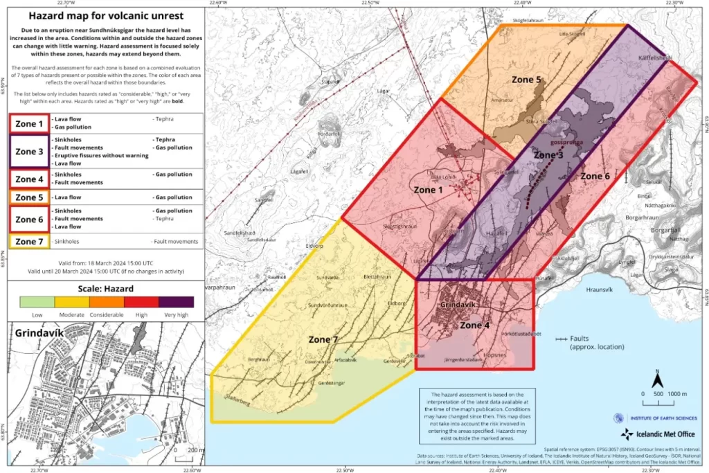
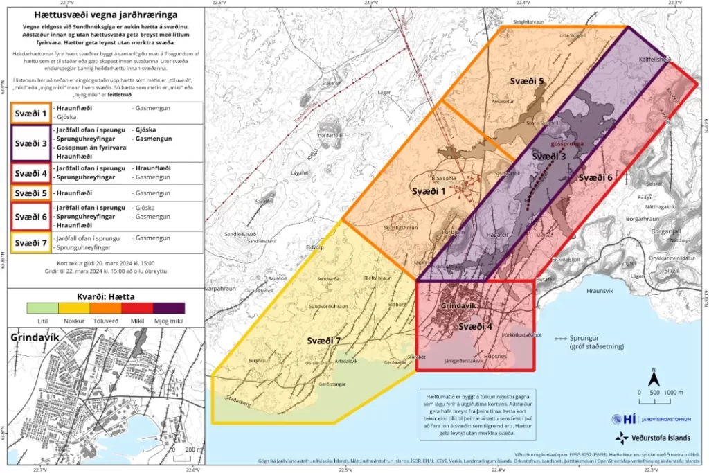
IMO has updated the hazard assessment map today, accounting for the latest data. The map is valid until March 20, unless the situation changes.
19:33 UTC, March 21
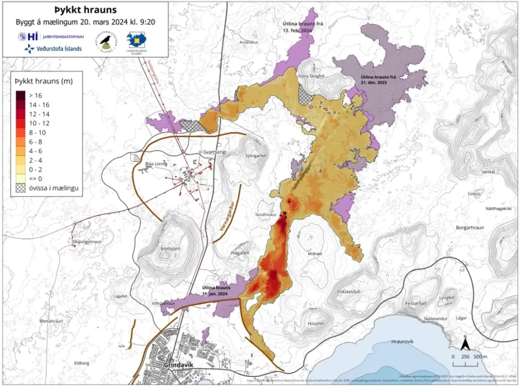
A survey flight by experts from the Institute of Natural History and Land Survey of Iceland on March 20 provided insights into the eruption’s scale, estimating the average lava flow rate between March 17 and 20 at approximately 14.5 m3/s (512 ft3/s), mirroring the flow rates of the Fagradalsfjall eruptions from 2021 to 2023.
Currently, the lava covers an area of 5.58 km2 (2.1 mi2) with a volume of about 20.9 million m3 (738 million ft3), reaching thicknesses of over 16 meters (52 feet) near the craters.
Minor deformations continue to be measured in the Svartsengi area and around the magma tunnel, with movements so slight that daily changes are indiscernible. Therefore, it will take several days to a week of measurements to determine any ongoing uplift at Svartsengi. It’s evident, however, that the magma previously accumulating under Svartsengi is now predominantly surfacing, fueling the eruption.
The risk assessment map updated on March 20, to remain valid until March 22, indicates a decrease in the risk level from high to considerable in Area 1 (Svartsengi), while maintaining a high-risk level in Area 4 (Grindavík) due to the dangers of fissure falls, movements, and lava flow. Area 3 (the Sundhnúks crater series) faces a very high risk from gas pollution, though the overall risk of gas pollution has been downgraded from high to considerable in other areas, reflecting reduced gas emissions since the eruption’s onset. This assessment also considers the weather and forecasted distribution, affecting the spread of gas pollution and pyroclastic materials.
Read the full March 21 update here:
04:21 UTC, March 28
Eruptive activity has been quite stable since Monday, March 25, IMO reported on March 27.
Eruption tremor has remained consistent since then, as has the activity in the three craters. Lava continues to flow southward from the craters mostly atop the lava field formed during the first days of the eruption.
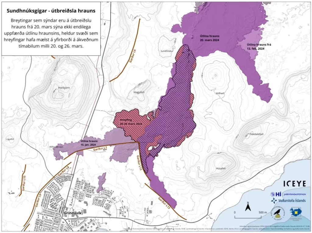
The following image shows the extension of the lava field as extrapolated from satellite images (ICEYE). The latest acquisition was on March 26 and it shows the widening of the lava field towards the west, south of Hagafell, as well as further lava advancement towards the east and the south of the active vents.
Uplift continues in Svartsengi but at a slower rate than before previous eruptions or dike intrusions in recent months. This suggests that magma is still accumulating beneath Svartsengi despite ongoing eruption. Little to no seismic activity has been detected in the area.
Additionally, high levels of SO2 pollution have been measured over the past few days.
At around 03:00 UTC on March 26, Blue Lagoon station registered levels of SO2 up to 7 000 micrograms/m3. Around 04:00 on March 27, the station in Grindavík (Nesvegur) measured concentrations up to 9 000 micrograms/m3.
Such concentrations are considered unhealthy, IMO said, adding that people are recommended to follow the instructions provided by the Environment Agency of Iceland and the Office of the National Medical Examiner.
Around 12:00 UTC on March 26, the station in Hafnir also showed high concentrations of SO2 up to about 2 000 micrograms/m3.
“The amount of SO2 released by the eruption and the meteorology in the area are still creating the conditions for severe gas pollution in the peninsula,” IMO said.
I'm a dedicated researcher, journalist, and editor at The Watchers. With over 20 years of experience in the media industry, I specialize in hard science news, focusing on extreme weather, seismic and volcanic activity, space weather, and astronomy, including near-Earth objects and planetary defense strategies. You can reach me at teo /at/ watchers.news.
At your updated article — Continuous lava flow threatens Grindavík barriers, Iceland —
– The Second ‘Lower Feed’ was appreciated for the short time that it was ‘On Line’ – Nick
I do hope that the various views on ‘Bottom Feed’ become available again
– for there is currently NO useable information being displayed on the ‘Upper Feed’ about what is actually happening with this Volcanic Eruption
FYI – There has been no change since 21:48:50 UTC – 24 Apr 2024 on
– The ‘Lower View’ – Top Right ‘Live Feed’
— FROM pORBJORN CLOSE WIDE—
– or –
— FROM pORBJORN CLOSE UP —
FYI – There is One (1) area of significant Vapor/Smoke for the past few areas behind the hill at the far of
the ‘Lower View’ – Center-Mid Small ‘Live Feed’ — FROM SANDHOLL WIDE —
– And it is ONLY visible on that one view
.
With my apology – That significant Vapor/Smoke is/was behind the darker hill on the Right side of
– The ‘Lower View’ – Center-Mid Small ‘Live Feed’ — FROM SANDHOLL WIDE —
The last time that I saw it was at +/- 04:50 UTC – Two (2) factors – Increasing Ambient Light – and a wind shift from the left to the right on that view
– Nick
– The hill on the Far Right Side of that view that is only partly visible on the ‘Lower View’ – Center-Mid Small ‘Live Feed’ — FROM SANDHOLL WIDE —
Thank you for the message
— ‘Volcano Status:’ / ‘Weather Conditions:’ / ‘Camera Status Status:’ —
FYI – On the ‘Lower View’ – On the Bottom Right ‘Live Feed’ — FROM HAGAFELL —
– It has only shown a rotating ‘Updating’ arrow’ for some time
.
FYI – on the ‘Upper View’ – Bottom Center (Small) ‘Live Feed’
— Langihryggur Cam 3A —
.
– And on the Right Center (Small) ‘Live Feed’
— Langihryggur Cam 3 —
there are ongoing intermittent ‘Update’ issues
FYI – on the ‘Upper View’ – Bottom Right ‘Live Feed’
— Vogastapi Cam 4 — since about 22:35 GMT there is an ‘issue’ with that ‘fuzzy’ feed
Thank you – the ‘fuzzy’ feed is back ‘On Line’
FYI – On the ‘Lower View’ –ONLY the Bottom Right ‘Live Feed’ is ‘Active
— FROM HAGAFELL —
-With a ‘Time Delay’ from your ‘Master Time’ on the Upper View’
.
Thank you for getting the ‘Live Feeds’ back ‘On Line’
.
FYI – The feeds on the ‘Lower View’ are not as crisp and clear now as they were previously – including all of the ‘texts’
– Nick
Thank you for the much clearer ‘Live Feeds’ on the ‘Lower View’
FYI – As of 2024/04/14 | 15:37
– The ‘Lower View’ – Top Right ‘Live Feed’
— FROM pORBJORN CLOSE UP — No Change since ?
.
ALSO – The ‘Lower View’ – Center-Mid Small ‘Live Feed’
— FROM SANDHOLL WIDE — NO Change since ?
.
Thank you for showing that helicopter night rescue operation – which is not for the faint-hearted
.
Thank you for getting the ‘Live Feds’ back up
– Nick
FYI – The ‘Lower View’ – Bottom Left ‘Live Feed’
— FROM SANDHOLL CLOSE — NO change since 12:30:11
.
– The ‘Lower View’ – Center-Mid Small ‘Live Feed’
— FROM SANDHOLL WIDE — NO Change since ?
.
– The ‘Lower View’ – Top Right ‘Live Feed’
— FROM pORBJORN CLOSE UP — No Change since ?
.
ALSO – The ‘Lower View’ – Top Left ‘Live Feed’
— FROM pORBJORN WIDE — The ‘Time Clock’ is 10+ Minutes behind what is shown on the bottom of the ‘Upper View’
.
– The ‘Lower View’ – Center Left Small ‘Live Feed’
— FROM pORBJORN WIDE — There is no apparent change since ?
.