
Fairly constant rate of eruption at Reykjanes, Iceland
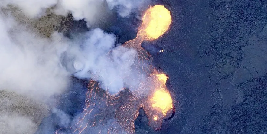
Image credit: IMO. Acquired on March 20, 2024
A fissure eruption that started on Reykjanes Peninsula, Iceland on March 16, 2024, continues at a fairly constant rate, with an average lava flow from the craters of about 14.5 m3 per second (512 feet3/s) from March 17 to 20. About 700 people at the Blue Lagoon spa and several in the town of Grindavík were evacuated within a 30-minute period after the start of the eruption.
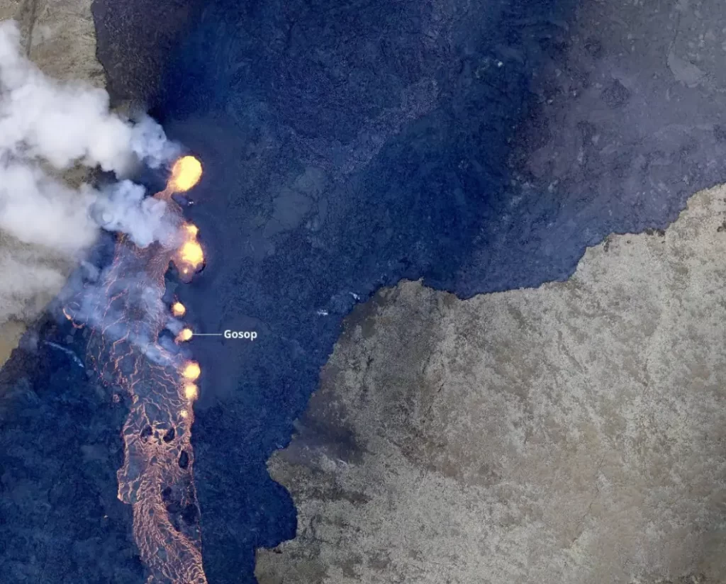
At 13:50 UTC on March 21, the Icelandic Met Office (IMO) reported that the same vents still appear active and craters continue forming around them. Lava flows south from the craters in an active lava river on the surface and below the solidified surface of the lava.
Experts from the Institute of Natural History and Land Survey of Iceland went on a survey flight over the eruption centers on March 20. Based on the data collected during that flight, it is estimated that the average lava flow from the craters in the period from March 17 to 20 was around 14.5 m3/s (512 feet3/s) — similar to the lava flow that was measured in the volcanic eruptions at Fagradalsfjall 2021 – 2023. However, there was much more lava flow from the craters during the first 24 hours of the eruption, which began on the evening of March 16.
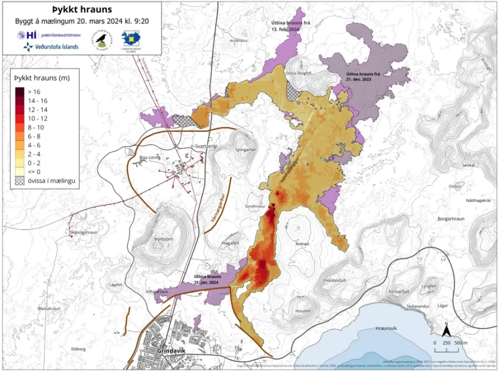
The area of the lava is now 5.58 km2 (2.1 mi2) and its volume is about 20.9 million m3 (738 million ft3).
The map below shows the extent and thickness of the lava as mapped yesterday morning, March 20. It shows that the lava is over 16 m (52 feet) thick close to the craters.
Small deformation is still measured in the Svartsengi area and around the magma tunnel but movements are so small that no significant changes can be seen between days. It therefore takes a few days to a week of measurements to assess whether uplift is still present at Svartsengi. However, it is immediately clear that magma that previously accumulated under Svartsengi is now mostly flowing directly to the surface and feeding the eruption.
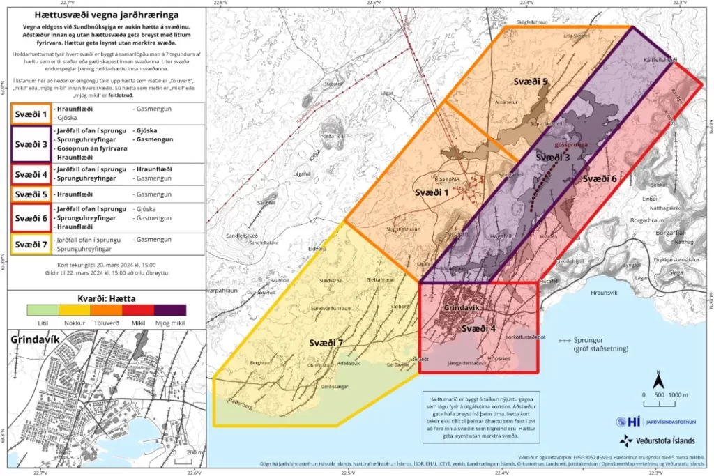
The risk assessment map was updated on March 20 and will remain in effect until March 22 without any changes.
The risk in Area 1 (Svartsengi) is now estimated to be considerable but was previously estimated to be high. The risk in Area 4 (Grindavík) is still assessed as high, as the risk of falling into a fissure, fissure movements, and lava flow is considered high. In Area 3 (the Sundhnúks crater series) the risk due to gas pollution is considered very high, but in all other areas, the risk of gas pollution is now assessed to be considerable — previously it was high. This change is due to less gas emission from the eruption than at the beginning. The risk of gas pollution is also assessed based on the weather and distribution forecast for the next few days, which affects their spread.
References:
1 Stöðug virkni í eldgosinu – Hraun flæðir suður af gígunum í virkri hrauná – IMO – March 21, 2024
I'm a dedicated researcher, journalist, and editor at The Watchers. With over 20 years of experience in the media industry, I specialize in hard science news, focusing on extreme weather, seismic and volcanic activity, space weather, and astronomy, including near-Earth objects and planetary defense strategies. You can reach me at teo /at/ watchers.news.
27 March – Are there any further affects on homes, buildings, roads, etc… by the continuing lava flow(s) ?