
Volcanic eruption in Reykjanes Peninsula continues to pose risks, ground uplift continues, Iceland
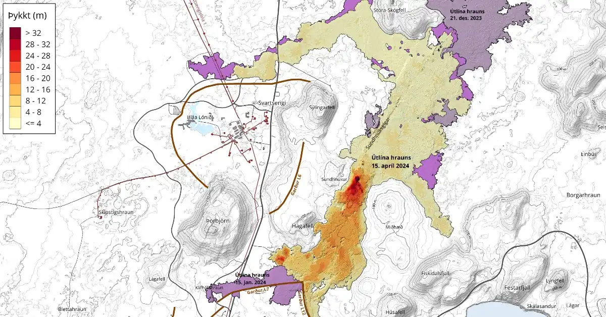
Image credit: IMO
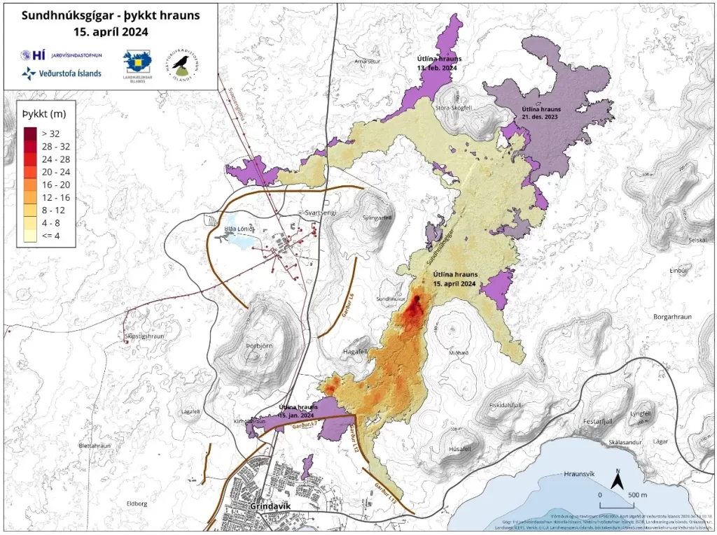
The ongoing volcanic eruption on Iceland’s Reykjanes Peninsula, which began at 20:23 UTC on March 16, 2024, continues to impact the area with significant ground uplift and persistent hazards from volcanic gas emissions. The eruption, centered at the Sundhnúkur crater row, shows no signs of abating, with an expanding lava field now covering 6.15 km2 (2.35 mi2).
As of April 18, the Icelandic Met Office (IMO) confirms that the lava field volume has reached 33.2 million m3 (1.17 billion feet3), a slight increase from earlier measurements.
The current lava flow rate from the active crater averages 3.2 m³/s (113 ft³/s), based on the latest data spanning April 8 – 15. This rate represents a minor decrease from the 3.6 m³/s (127 ft³/s) observed from April 3 – 8.
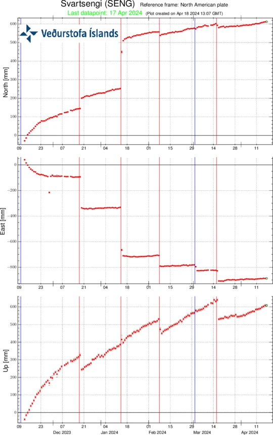
In response to the eruption, local authorities continue to monitor the uplift at Svartsengi, indicating ongoing magma movement beneath the surface.
Approximately half of the ascending magma is accumulating in the underground reservoir, with the remainder feeding the eruption at the surface. This geological activity has led to sustained land deformation and contributed to a series of small earthquakes near Lágafell, which began on April 14 and persisted for over four hours.
The Icelandic Institute of Natural History (IINH) and the National Land Survey of Iceland (NLSI) conducted an aerial surveillance operation on April 15 to update the mapping of the lava field using photogrammetry. Their findings confirm the continuous expansion of the lava field, primarily towards the southeast.
The result of previous measurements by the IINH and NLSI photogrammetry team can be seen in the table below:
| From | To | Average lava flow during period (m3/s) | Area (km2) | Volume (million m3) | Average thickness of lava field (m) |
| March 16, 2024 | March 17, 2024 | 234 ± 9 | 5,72 | 18,1 ± 0,8 | 3,2 ± 0,1 |
| March 17, 2024 | March 20, 2024 | 14,5 ± 0,6 | 5,58 | 20,9 ± 0,5 | 3,7 ± 0,1 |
| March 20, 2024 | March 27, 2024 | 7,8 ± 0,7 | 5,99 | 25,7 ± 1,9 | 4,3 ± 0,3 |
| March 27, 2024 | April 3, 2024 | 6,6 ± 0,3 | 6,13 | 29,7 ± 1,7 | 4,8 ± 0,3 |
| April 3, 2024 | April 8, 2024 | 3,6 ± 0,7 | 6,14 | 31,3 ± 2,4 | 5,1 ± 0,4 |
| April 8, 2024 | April 15, 2024 | 3,2 ± 0,2 | 6,15 | 33,2 ± 0,8 | 5,4 ± 0,1 |
Health advisories remain in effect due to the continuous emission of volcanic gases, which pose a significant pollution hazard.
Residents in the Reykjanes Peninsula are urged to stay informed about air quality levels and familiarize themselves with safety protocols regarding air pollution from volcanic activity.
References:
1 Ground uplift continues at a steady rate – IMO – April 18, 2024
I'm a dedicated researcher, journalist, and editor at The Watchers. With over 20 years of experience in the media industry, I specialize in hard science news, focusing on extreme weather, seismic and volcanic activity, space weather, and astronomy, including near-Earth objects and planetary defense strategies. You can reach me at teo /at/ watchers.news.
… “with an expanding lava field now covering 6.15 km² (23.5 mi2).”
The decimal point is in the wrong position for the sq. mile figure, which should be ~2.37 sq. mi.
Thanks for the updates, appreciated
Thanks for spotting it.
? — Displacements on the GPS station SENG in Svartsengi since 11 November 2024 to north, east and vertical (top, middle, bottom). The bottom curve shows … —