
Tropical Cyclone “Kirrily” forecast to make landfall over Queensland as Category 2 system
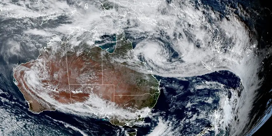
Featured image: Tropical Cycl0ne "Kirrily" at 05:50 UTC on January 24, 2024. Credit: JMA/Himawari-9, RAMMB/CIRA, The Watchers
Tropical Cyclone “Kirrily” — currently a Category 1 system — is set to intensify and make landfall in Queensland, Australia on January 25, 2024, as a Category 2 cyclone, with damaging winds and heavy rainfall expected.
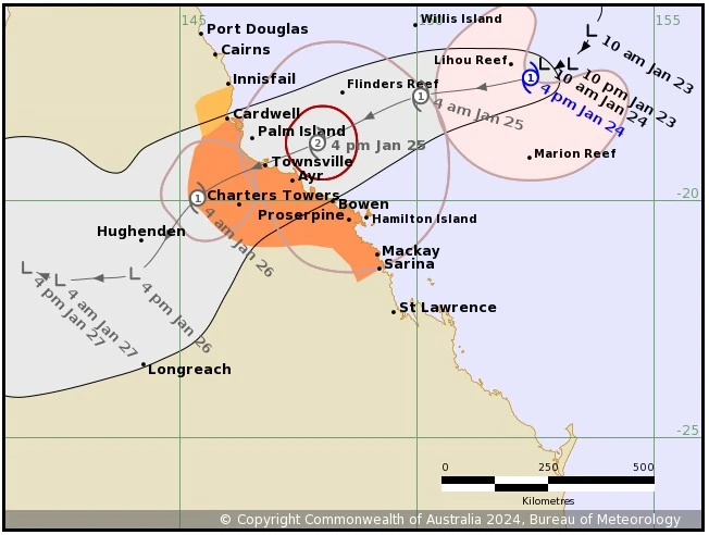
- BOM is warning people living between Innisfail to Cardwell, and inland to Charters Towers, to consider what action they will need to take if the cyclone threat increases.
- People between Cardwell to Townsville and Bowen to Sarina, including Mackay and Bowen should take precautions and listen to the next advice.
- People between Townsville and Bowen, and the Whitsunday Islands should immediately commence or continue preparations, especially securing boats and property using available daylight hours.
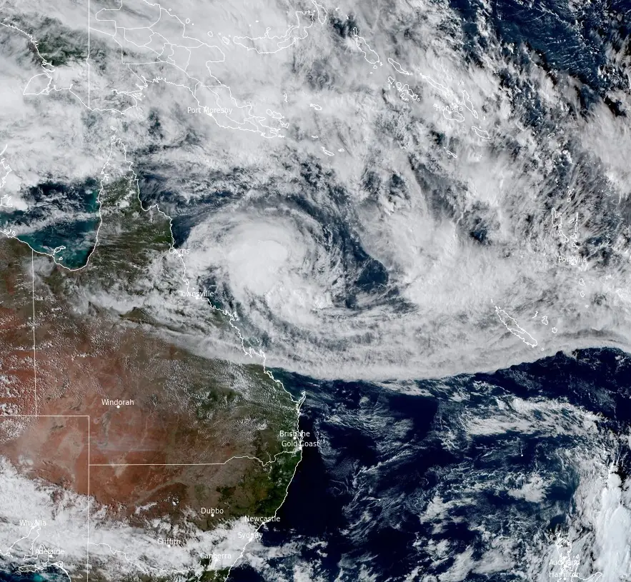
Tropical Cyclone “Kirrily” formed in the Coral Sea off the coast of Queensland, Australia on Wednesday, January 24, 2024, marking the third named storm of the 2023/24 Australian region cyclone season.
As of 16:00 AEST (05:00 UTC) today, Kirrily is a slow-moving Category 1 cyclone with sustained winds near the center of 75 km/h (47 mph), gusting up to 100 km/h (62 mph). The cyclone’s center was approximately 630 km (391 miles) east-northeast of Townsville and 530 km (329 miles) northeast of Mackay.
Watch zone: Innisfail to Cardwell.
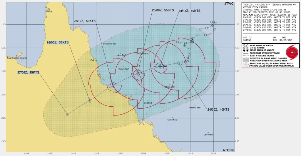
The Australian Bureau of Meteorology (BOM) has issued warnings for residents in the affected region, anticipating Kirrily’s landfall between Cardwell and Bowen on the evening of January 25, 2024, as a Category 2 system. Once it crosses the coast, Kirrily is expected to weaken rapidly into a tropical low, moving further inland and across central Queensland, bringing heavy to intense rainfall to the northern interior and western regions from Friday into the weekend.
Key hazards include gales with damaging wind gusts up to 120 km/h (75 mph) developing around the Whitsunday Islands and extending to mainland communities between Ayr and Sarina by Thursday morning. The system may also bring destructive wind gusts up to 140 km/h (87 mph) to coastal and island communities between Cardwell and Proserpine, including Townsville and the Whitsunday Islands, by late Thursday.
Heavy rainfall, which may lead to flash flooding, is likely to develop along coastal areas between Innisfail and Sarina from early Thursday, with intense rainfall near the cyclone’s track, heightening the risk of dangerous and life-threatening flash flooding during its coastal crossing. A flood watch is in effect for these areas.
With the cyclone’s approach and coastal crossing, a storm tide is expected between Townsville and Mackay, potentially causing minor flooding along the foreshore. Residents in affected areas are advised to take measures to protect their property and be prepared to help neighbors.
The BOM and local authorities recommend that residents between Innisfail to Cardwell, and inland to Charters Towers, stay vigilant and consider necessary actions if the cyclone threat escalates. Those in the path of the cyclone, particularly between Cardwell and Sarina, including Mackay and Bowen, are urged to take precautions and stay updated with the latest advice.
People between Townsville and Bowen, and the Whitsunday Islands should immediately commence or continue preparations, especially securing boats and property using available daylight hours.
During Friday, the system is expected to become a tropical low, and heavy rainfall may develop across the northern interior and western Queensland into the weekend as the system tracks inland.
References:
1 TROPICAL CYCLONE ADVICE NUMBER 15 – BOM – Issued at 4:49 pm EST on Wednesday 24 January 2024
I'm a dedicated researcher, journalist, and editor at The Watchers. With over 20 years of experience in the media industry, I specialize in hard science news, focusing on extreme weather, seismic and volcanic activity, space weather, and astronomy, including near-Earth objects and planetary defense strategies. You can reach me at teo /at/ watchers.news.
Commenting rules and guidelines
We value the thoughts and opinions of our readers and welcome healthy discussions on our website. In order to maintain a respectful and positive community, we ask that all commenters follow these rules.