
Tropical Storm “Candice” forms just north of Mauritius, bringing very heavy rainfall
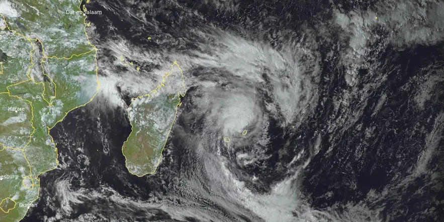
Featured image: Tropical Storm "Candice" at 12:00 UTC on January 24, 2024. Credit: EUMETSAT/Meteosat-10, RAMMB/CIRA, The Watchers
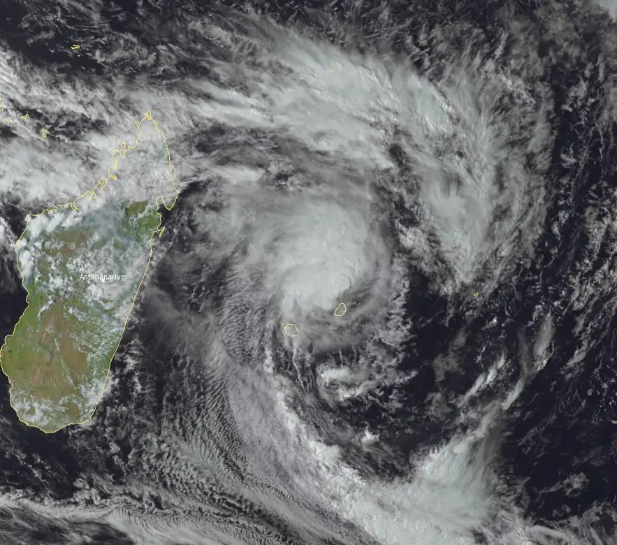
Tropical Storm “Candice” formed close to Mauritius around 08:00 UTC on January 24, 2024, as the third named storm of the 2023/24 South-West Indian Ocean tropical cyclone season. Candice is currently a quasi-stationary system with its center located just north of Mauritius.
- Heavy rainfall and gale-force winds are expected in Mauritius today into Thursday, January 25, , with precipitation levels ranging from 50 mm to 200 mm (approximately 2 to 8 inches) within 24 hours, especially in highland areas.
- Heavy rain is predicted over the southern half of the Reunion, persisting until Friday morning. Rainfall amounts are estimated to be around 100 mm to 200 mm (approximately 4 to 8 inches) within 24 hours, with higher accumulations of 300 mm to 500 mm (approximately 12 to 20 inches) in exposed relief areas.
- Additionally, sea conditions are expected to be very rough, with waves reaching up to 4 meters (13 feet) from Wednesday evening (LT).
At 12:00 UTC, the center of quasi-stationary Moderate Tropical Storm “Candice” was located just 30 km (18 miles) N of the northern tip of Mauritius. The system had maximum average wind speed of 65 km/h (40 mph) and central pressure of 993 hPa.
According to the RSMC La Reunion, convective activity between 06:00 and 12:00 UTC today has relatively diminished and remained mainly contained in the north-western quadrant of the circulation. The low-level circulation seems better defined, and the center of the system remains on the edge of the deep convection, as shown by the GPM 37 and 85 GHz microwave passes at 11:26 UTC, reflecting shear on the system.
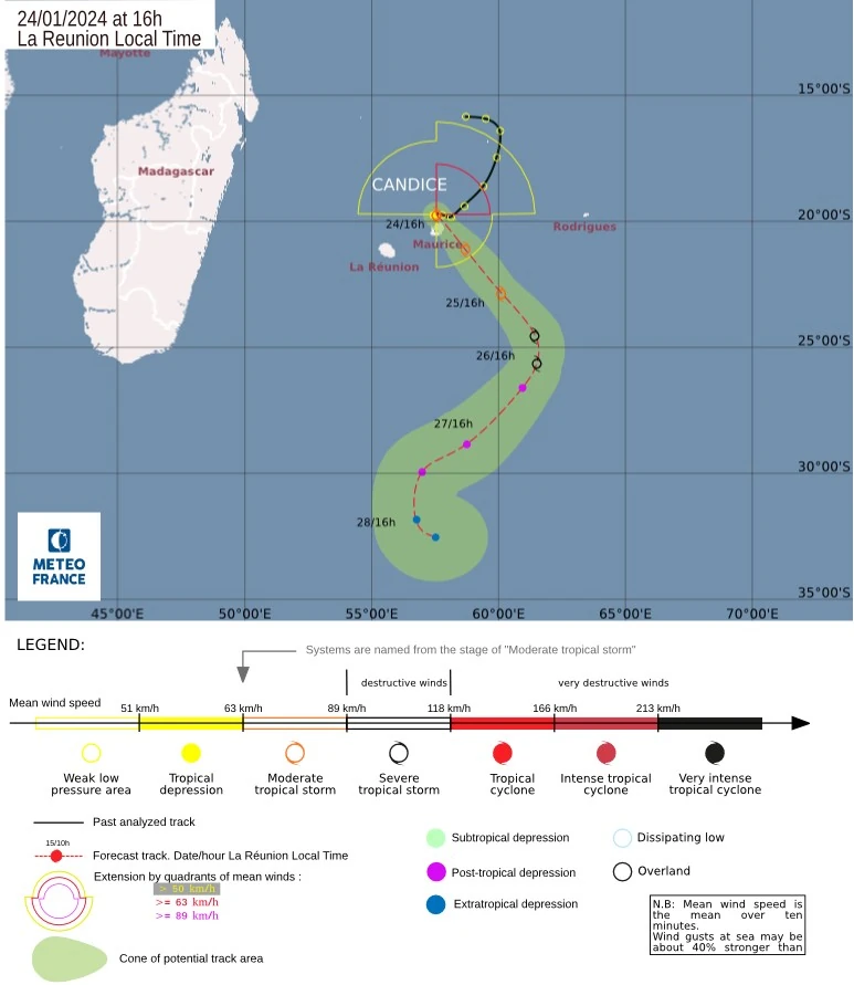
In terms of track, the first stages remain tricky due to a weak steering flow. Currently looping or quasi-stationary to the north of Mauritius, Moderate Tropical Storm “Candice” will continue to move slowly as the ridge of high pressure shifts eastwards.
With the arrival of a south-westerly trough today and the strengthening of the ridge of high pressure to the northeast, the main flow will gradually turn to the northwest, favoring an accelerating movement to the southeast. At 24 hours, confidence in the track is better, with a consensus among all the numerical models. By Friday, January 26, with the arrival of a subtropical ridge to the southwest and then east, and the easing of the main flow, Candice should slow down and then turn southwest, accelerating again.
Candice is benefiting in the short term from excellent convergence on the equatorial coast, with a powerful monsoon flow.
Intensification is beginning and should persist over the next 36 – 48 hours thanks to an increasingly favorable environment (strong ocean potential, decreasing vertical shear, and increasing upper-level divergence). Candice could then reach the stage of a strong tropical storm between Thursday and Friday.
However, there is still a great deal of uncertainty surrounding this intensification, since the models are not all converging as to the consolidation of the system’s core, so the next few hours will be more informative as to the choice of progressive intensification.
At the end of the week, the strengthening of the north-westerly shear and the significant drop in oceanic potential south of 25S should encourage the system to weaken or even go extratropical.
Expected impacts in the next 72 hours:
Mauritius:
- Gale force possible during Wednesday night to Thursday.
- Heavy rain is possible until Thursday. Rainfall totals in the range of 50 mm to 200 mm (2 – 8 inches) in 24 hours, particularly over highlands.
- Very rough sea 4 m (13 feet) from Wednesday evening.
Reunion:
- Near gale force possible during Wednesday night to Thursday.
- Heavy rain over the southern half, continuing until Friday morning. Total rainfall around 100 to 200 mm (4 – 8 inches) in 24 h, reaching 300 to 500 mm (12 – 20 inches) on exposed relief.
- Very rough sea 4 m (13 feet) from Wednesday evening.
Rodrigues:
- Very rough sea 4 m (13 feet) from Wednesday, weakening Thursday evening.
References:
1 TROPICAL CYCLONE FORECAST WARNING (SOUTH-WEST INDIAN OCEAN) – WARNING NUMBER: 9/3/20232024 – MODERATE TROPICAL STORM 3 (CANDICE) – RSMC La Reunion – 12:00 UTC on January 24, 2024
I'm a dedicated researcher, journalist, and editor at The Watchers. With over 20 years of experience in the media industry, I specialize in hard science news, focusing on extreme weather, seismic and volcanic activity, space weather, and astronomy, including near-Earth objects and planetary defense strategies. You can reach me at teo /at/ watchers.news.
Commenting rules and guidelines
We value the thoughts and opinions of our readers and welcome healthy discussions on our website. In order to maintain a respectful and positive community, we ask that all commenters follow these rules.