
Tropical Storm “Eleanor” forms over the southern Indian Ocean
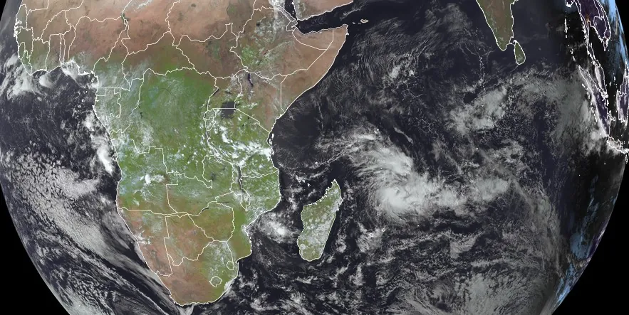
Featured image: Tropical Storm "Eleanor" at 11:15 UTC on February 20, 2024. Credit: EUMETSAT/Meteosat-9, RAMMB/CIRA, The Watchers
Tropical Storm “Eleanor” formed over the southern Indian Ocean on February 19, 2024, as the 6th named storm of the 2023/24 South-West Indian Ocean cyclone season. The cyclone is strengthening as it turns southward toward Saint Brandon and Mauritius. The current forecast track takes its center very close to Mauritius on February 23.
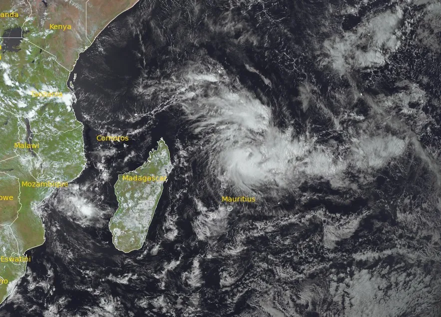
At 06:00 UTC on February 20, the center of Tropical Storm “Eleanor” was located about 745 km (462 miles) N of Mauritius, moving E at 24 km/h (15 mph).
The system had an average wind speed of 75 km/h (46 mph) and a central pressure of 997 hPa.
In 6 hours to 06:00 UTC today, the cloud pattern near the Eleanor Center has remained fairly ill-defined, with convection bursts showing little curvature, according to RSMC La Reunion.
Eleanor should continue on an east-southeasterly track over the next 12 hours, driven by high near-equatorial geopotentials. Then this evening (LT), the system should slow down, held back by the swelling of a ridge to the east extending to the south of the system, which will cause it to turn southwards overnight and then to the south-south-west, with a close passage to the vicinity of Saint-Brandon on Wednesday, February 21.
The system should transit to the northeast of the Mascareignes Islands (Reunion and Mauritius) on Thursday.
“This forecast will be closely related to the swelling/collapsing of the ridge of high pressure to the south of the system on Thursday or Friday,” RSMC La Reunion meteorologists said.
“It’s on this precise point that current guidance remains split on the scenario to be followed. This is reflected in the spread of ensemble forecast members (EPS and GEFS), as well as determinist models. The current forecast is a blend of the latest runs of the large-scale models and the statistical model CONW, in relative agreement with the AROME forecast.”
As it weakens, Eleanor should be picked up again by the low-level trade winds, leading to a westerly track. Overall, Eleanor is benefiting from good environmental conditions, strong ocean potential, low shear, and good upper divergence for the next 24 hours, which should lead to more or less quick deepening depending on the scenario.
A rapid intensification is possible due to the small size of the system. It should therefore reach the tropical cyclone stage by Wednesday to Thursday night (LT) at the latest.
From Wednesday and especially Thursday, the northwesterly shear is expected to strengthen significantly, probably leading to a pronounced weakening on Friday, February 23, as a result of dry intrusions.
By late week, the system is expected to evolve into a residual low to the south and then southwest of Reunion Island.
Impacts expected over the next 72 hours
Saint-Brandon Island
- Gale force winds are very likely Tuesday evening through Wednesday. Storm-force winds are possible on Wednesday.
- Rainfall totals of 100 to 200 mm (4 – 8 inches) over the next 48 hours.
- Waves of 4 to 5 m (13 – 16 feet) between Tuesday afternoon and Wednesday evening. Swift improvement is expected thereafter as the system moves away.
Mauritius
- Gale force winds likely Thursday during the day. Storm-force winds are possible during Thursday, but risk weakening.
- Rainfall totals of 50 to 150 mm (2 – 6 inches) on Thursday, but rather uncertain.
- Waves of 4 to 8 m (13 – 26 feet) between Wednesday evening and Thursday afternoon. Gradual improvement is expected thereafter.
References:
1 RSMC / TROPICAL CYCLONE CENTER / LA REUNION – TROPICAL CYCLONE FORECAST WARNING (SOUTH-WEST INDIAN OCEAN) – WARNING NUMBER: 7/7/20232024 – MODERATE TROPICAL STORM 7 (ELEANOR) – RSMC La Reunion – 07:49 UTC on February 20, 2024
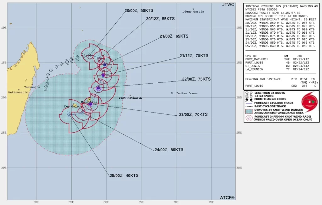
2 Tropical Cyclone 16S (Eleanor) Warning #03 – JTWC – Issued at 20/0300Z
I'm a dedicated researcher, journalist, and editor at The Watchers. With over 20 years of experience in the media industry, I specialize in hard science news, focusing on extreme weather, seismic and volcanic activity, space weather, and astronomy, including near-Earth objects and planetary defense strategies. You can reach me at teo /at/ watchers.news.
Commenting rules and guidelines
We value the thoughts and opinions of our readers and welcome healthy discussions on our website. In order to maintain a respectful and positive community, we ask that all commenters follow these rules.