
GDACS issues Red alert for developing cyclone near Mauritius and La Reunion
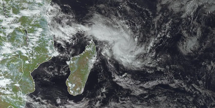
Featured image: Tropical Cyclone 05S at 12:00 UTC on January 12, 2024. Credit: EUMETSAT/Meteosat-9, RAMMB/CIRA, The Watchers
Residents of Mauritius and La Reunion are bracing for a possible significant impact from a developing tropical cyclone — Tropical Cyclone 05S, expected to rapidly intensify and pass between the islands on January 16, 2024, as a Category 3 hurricane equivalent. When named (Belal), this will be the second named storm of the 2023/24 South-West Indian Ocean cyclone season.
On January 11, 2024, Meteo-France (MFR) began tracking a tropical disturbance in the northern part of the basin. The disturbance quickly intensified, leading the Joint Typhoon Warning Center (JTWC) to issue a Tropical Cyclone Formation Alert (TCFA) on January 12. Shortly thereafter, the system was designated as a tropical depression by the MFR, and by 15:00 UTC the same day, the JTWC issued warnings classifying it as Tropical Cyclone 05S.
The Global Disaster Alert and Coordination System (GDACS) issued a Red alert due to possible high humanitarian impact based on the maximum sustained wind speed, exposed population and vulnerability.
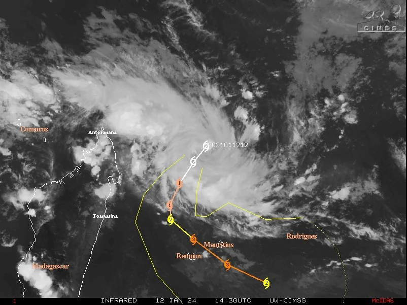
According to the Regional Specialized Meteorological Centre (RSMC) La Reunion, Tropical Cyclone 05S had mean maximum winds of 56 km/h (35 mph), with gusts reaching up to 74 km/h (46 mph) at 12:00 UTC today, and a minimum central pressure of 1 000 hPa.
Currently, the system is moving southwest toward northern Madagascar but is projected to change course to the southeast on January 14. It is forecast to pass between Mauritius and Reunion on January 15, with maximum sustained winds of 205 km/h (127 mph), equivalent to a Category 3 hurricane on the Saffir-Simpson scale.
The Joint Typhoon Warning Center (JTWC) has analyzed the latest satellite imagery, revealing significant consolidation and intensification of Tropical Cyclone 05S. The imagery shows well-defined spiral bands coalescing around a more clearly defined low-level circulation center (LLCC). Despite a slight warming in cloud top temperatures recently, vigorous convective activity continues, particularly on the system’s northern side.
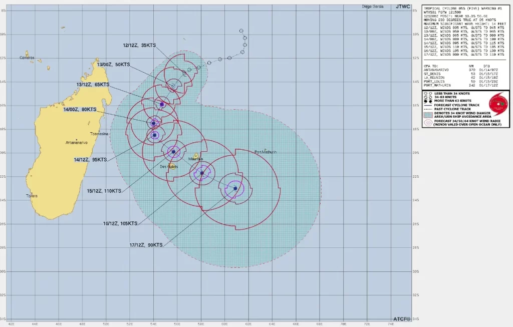
A detailed review of a recent AMSR2 36GHz microwave image shows a compact, well-formed inner core characterized by moderate convection. Strong inflow bands are evident on the western and northern sectors of the LLCC, alongside a weak low emissivity region marking the center of circulation. The JTWC has placed high confidence in the cyclone’s initial position (13.3S 56.6E), based on this imagery and notable features like a dimple in the satellite animation.
The cyclone’s initial intensity of 65 km/h (40 mph) aligns with a significant improvement in structural organization and corresponds with T2.5 Dvorak intensity estimates obtained from PGTW and DEMS.
Tropical Cyclone (TC) 05S is anticipated to maintain a southwestward trajectory, following the western edge of the steering ridge for the next 36 hours, JTWC forecasters said at 15:00 UTC today. During this initial phase, the cyclone’s movement is expected to be relatively consistent in speed, steered by the persistent ridge to the east.
Around 36 hours into the forecast, the cyclone’s path is predicted to shift more southward and slow down, correlating with a reorientation of the ridge into a northwest-southeast axis. After 15:00 UTC on January 14, TC 05S is forecasted to firmly adopt a southeastward trajectory as the ridge completes its reorientation. The cyclone is expected to pass between La Reunion and Mauritius around the 96-hour mark (15:00 UTC, January 16) before continuing into the open waters of the Southern Indian Ocean.
In terms of intensity, the environmental conditions surrounding TC 05S are highly conducive for rapid intensification as the low-level circulation center (LLCC) is expected to consolidate imminently. These optimum conditions are forecasted to persist for the next 48 hours, facilitating the system’s intensification by at least 110 km/h (70 mph) during this period. The favorable conditions will continue for an additional 24 hours, likely leading to further intensification of the system up to at least 195 km/h (120 mph) or potentially higher, before it reaches the Mascarene Archipelago.
After 15:00 UTC on January 16, the cyclone is expected to encounter a reduction in ocean heat content and sea surface temperatures (SSTs), coupled with an increase in shear. These factors will contribute to a gradual weakening trend as TC 05S moves poleward.
References:
1 Tropical Cyclone 05S (Five) Warning #01 – JTWC – Issued at 15:00 UTC on January 12, 2024
I'm a dedicated researcher, journalist, and editor at The Watchers. With over 20 years of experience in the media industry, I specialize in hard science news, focusing on extreme weather, seismic and volcanic activity, space weather, and astronomy, including near-Earth objects and planetary defense strategies. You can reach me at teo /at/ watchers.news.
Commenting rules and guidelines
We value the thoughts and opinions of our readers and welcome healthy discussions on our website. In order to maintain a respectful and positive community, we ask that all commenters follow these rules.