
Tropical Cyclone “Batsirai” expected to deliver catastrophic blow to Madagascar
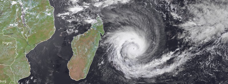
Featured image: Tropical Cyclone "Batsiari" at 10:15 UTC on February 2, 2022. Credit: EUMETSAT/Meteosat-8, RAMMB/CIRA, TW
Tropical Cyclone "Batsirai" formed well east of Madagascar on January 27, 2022, at a time Madagascar, Mozambique and Malawi were still assessing severe damage caused by the passage of Tropical Cyclone "Ana."
- Environmental conditions favor further intensification, leading to a possible catastrophic landfall in Madagascar on February 5. Up to 600 mm (24 inches) of rain is possible in some areas.
- Batsirai is the second named storm of the 2021/22 Southwest Indian Ocean cyclone season.
At 06:00 UTC on February 2, Batsirai was an Intense Tropical Cyclone located approximately 246 km (153 miles) NNE of Port Louis, Mauritius.
Its maximum 10-minute sustained winds were 185 km/h (115 mph), with gusts up to 260 km/h (160 mph), while maximum 1-minute sustained winds were at 220 km/h (140 mph).
The minimum central barometric pressure was 940 hPa and the system was moving WSW at 17 km/h (10 mph).
"During the last few hours, the eye configuration has clearly improved in both visible and infrared imagery despite a warming of the cloud tops," RSMC La Reunion said at 06:00 UTC today.1
The cyclone remains under the influence of two contradictory steering flows coming from the subtropical ridge in the southwest and from a near equatorial ridge of middle troposphere in the northeast.
Currently, under the influence of the subtropical ridge, Batsirai is moving in a general west-southwest direction.
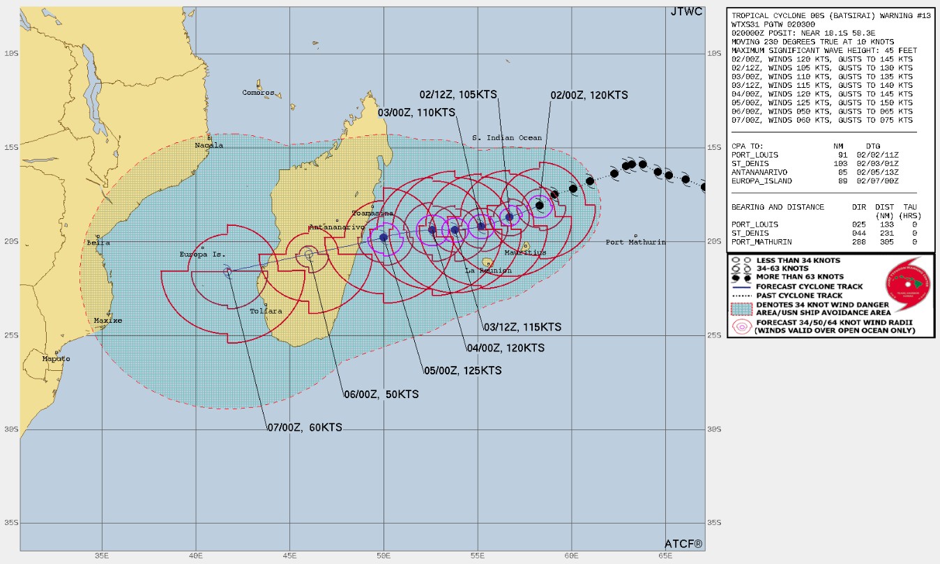
On this trajectory, it should pass near Mauritius tonight at about 130 km (80 miles) with an uncertainty of 50 km (31 miles) and tomorrow morning at about 160 km (100 miles) from Reunion, again with an uncertainty of 50 km (31 miles). The presence of the islands could modify the track.1
From tomorrow, February 3, the subtropical ridge strengthens by the south-west allowing a resumption of a trajectory in the general direction of the west towards the east coast of Madagascar.
It could then land in the area of Mahanoro early Saturday, February 5. On Sunday and Monday, Batsirai could emerge in the south of the Mozambique Channel.
Currently, Batsirai is in a rather favorable environment until Friday with a very good divergence in the northern semicircle. The intensity until landing on Madagascar will be mainly driven by internal phenomena.
In particular, if a replacement cycle of the eyewall is announced, a weakening phase should start in the next 24 hours before a possible new intensification until landfall. This prediction is still quite uncertain, RSMC La Reunion said.
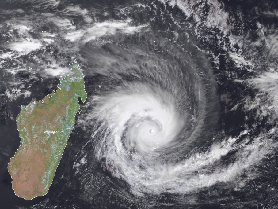
Tropical Cyclone "Batsiari" at 10:15 UTC on February 2, 2022. Credit: EUMETSAT/Meteosat-8, RAMMB/CIRA, TW
Impacts on inhabited lands
Mauritius and Reunion
The degradation of the meteorological conditions continues in Mauritius and Reunion. Even if the core of the cyclone should pass more than 100 km (62 miles) from the islands, significant impacts are to be feared, the center said.
Heavy rains are expected especially on the reliefs of the two islands.
The two islands should be concerned by gale-force winds, with gusts exceeding 110 km/h (68 mph) on the coast.
Swells could reach 5 m (16 feet).
The expected surge remains low, of the order of a few tens of centimeters.
These impacts could be reinforced by a possible replacement cycle of the eyewall.
Madagascar
The arrival of the cyclone is expected on Saturday on the east coast, potentially at a tropical cyclone or intense tropical cyclone stage.
With the beginning of the rain and wind impacts possible from Friday the uncertainty that remains on the forecast of the trajectory and intensity of such a dangerous system near inhabited lands requires the utmost caution. The population is invited to follow the evolution of the situation with attention.
References:
1 Tropical Cyclone 2 (Batsirai) – WTIO30 FMEE 020706 RSMC / TROPICAL CYCLONE CENTER / LA REUNION TROPICAL CYCLONE FORECAST WARNING (SOUTH-WEST INDIAN OCEAN)
I'm a dedicated researcher, journalist, and editor at The Watchers. With over 20 years of experience in the media industry, I specialize in hard science news, focusing on extreme weather, seismic and volcanic activity, space weather, and astronomy, including near-Earth objects and planetary defense strategies. You can reach me at teo /at/ watchers.news.
Commenting rules and guidelines
We value the thoughts and opinions of our readers and welcome healthy discussions on our website. In order to maintain a respectful and positive community, we ask that all commenters follow these rules.