
Increased erosion risk on Isle of Wight after historic landslide, U.K.
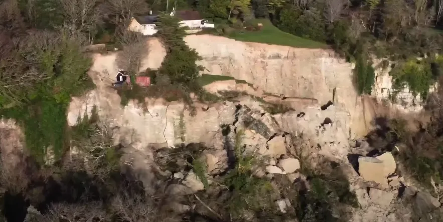
Image credit: Island Echo (stillshot)
Isle of Wight Council has issued warnings of possible further ground movement in Bonchurch, Ventnor, after experiencing one of the largest landslides ever recorded on the Isle of Wight and the south coast of Britain last month.
On December 10, 2023, the Isle of Wight witnessed a significant geological event when a major landslide occurred in Bonchurch, Ventnor, affecting an area of about 42 ha (approximately 104 acres).
This incident, displacing approximately 14 million cubic meters (nearly 494 million cubic feet) of material, stands as one of the largest landslides in modern history for both the Isle of Wight and the south coast of Britain.
As a result, around 20 properties near Leeson Road were evacuated due to the “devastating” landslide, which caused significant parts of the cliff edge along the road to collapse.
Bonchurch is located at the eastern end of the Ventnor landslide complex, the largest urban landslide site in Western Europe, landslides expert Dr. Dave Petley said.
Following the landslide, most residents were able to return to their homes after inspections by the council’s building control team. However, residents of a few properties remain advised to stay elsewhere, as the Isle of Wight Council has not ruled out the possibility of further ground movement.
Natasha Dix, the Isle of Wight Council’s service director for waste, environment, and planning, stated that the building control team would regularly monitor these properties. The council also prepared to issue emergency powers notices if necessary, to declare any building directly affected by movement or damage as unsafe.
Another landslide recently struck nearby Luccombe village, about 2.5 km (1.5 miles) north of Bonchurch. This event, coupled with the major landslide in Bonchurch, followed a period of prolonged wet weather and stormy seas, which have weakened the cliffs along the island’s south coast.
Roger Moore, Global Principal of Geoscience & Engineering Geology at Jacobs, noted the geological vulnerability of the island’s south coast, particularly an area known as the Undercliff.
The island’s geology, featuring Chalk, Upper Greensand, the Gault Formation (known as the ‘blue slipper clay’), and Lower Greensand, significantly contributes to its landslide susceptibility. Moore emphasized the correlation between extreme rainfall and landslide occurrence in the area.
References:
1 Isle of Wight on alert for further ground movement after biggest landslide in 20 years – New Civil Engineer – January 12, 2024
2 Bonchurch: a very large landslide on the Isle of Wight – The Landslide Blog – December 12, 2024
The Watchers team and our contributors bring the latest on extreme weather, earthquakes, volcanic eruptions, space weather, and all things science. We're all about making sense of the natural world and keeping you informed on what’s happening. Got a tip or a question? Hit us up using the form at newstips!
Commenting rules and guidelines
We value the thoughts and opinions of our readers and welcome healthy discussions on our website. In order to maintain a respectful and positive community, we ask that all commenters follow these rules.