
First imagery from next-generation FY-4A geostationary satellite
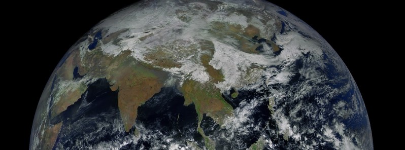
Image credit: NSMC/FY-4
China has released the first imagery from Fengyun-4A, the first of their second generation of Geostationary Meteorological Satellites. The satellite will support forecasts and warnings, numerical weather prediction, wildfire and space weather monitoring and more. It is expected to find a wide range of uses and societal benefits in reducing disasters produced by typhoons, rainstorms, floods, and space weather.
FY-4 introduces significant improvements over the current system which employs spin-stabilized satellites that can only achieve a fraction of the observation efficiency possible with three-axis stabilized satellites.
Fengyun (Chinese for ‘Winds and Clouds’) is China’s Meteorological Satellite Program, consisting of at least one operational satellite in Geostationary Orbit and several satellites in polar orbits, creating a satellite constellation to monitor the Chinese and surrounding territory and deliver timely data relevant for weather forecasting and nowcasting. The program saw its first launch back in 1988 when the Fengyun 1A satellite was launched into a Sun-Synchronous Orbit – Fengyun 1B followed in 1990.


Compared to FY-2, the next generation of Geostationary Meteorological Satellites has been considerably improved in terms of the quality and volume of data delivered, the network transmission bandwidth, data product generation and distribution – enabling an easier integration into forecasting and other applications.
FY-4 offers an enhanced scanning capability to be able to monitor small-scale weather phenomena while the microwave version addresses the need for three-dimensional sensing of the atmosphere from geostationary altitudes. As a new capability, FY-4 carries a solar payload to establish a space weather monitoring and warning capability.
Services provided by the FY-4 system include imaging, sounding, lightning mapping, and space environment monitoring plus auxiliary services – High- and Low-Rate Information Transmission, and support of Data Collection Platforms.
A total of seven FY-4 satellites are planned to be launched to remain in service through 2037 when a successor program will be inaugurated.
Find more FY-4A imagery, here. FENGYUN Satellite Data Center homepage is here.

Teo Blašković founded The Watchers in 2011 and edited it until 2026, covering seismic and volcanic activity, extreme weather, space weather and near-Earth objects. Articles on this page are his archive.
Published in the last 24 hours
- CPC posts a slight risk of heavy rain from the Gulf Coast to the Northeast urban corridor November 25-29, and a moderate risk of West Coast wind and Sierra snow on November 25
- Florida's east coast faces a moderate flash flood risk Wednesday through Friday, with 4 to 8 inches of rain forecast and the St. Johns River near Cocoa already in major flood at 17.13 feet
- Cyclone Akvan to make landfall between Nellore and Visakhapatnam around noon on November 20, IMD forecasts 120-130 km/h winds gusting to 145
- Radio pulses every 7.9 minutes reveal binary with white dwarf and Sun-like star Epicenter
