
Tropical Storm “Guillermo” nears Hawaii
Featured image: Tropical Storm "Guillermo" on August 4, 2015. Credit: UW-CIMSS.
Weakening Tropical Storm "Guillermo" is expected to pass north of Hawaii on August 5 and 6, 2015. NWS Central Pacific Hurricane Center in Honolulu issued a tropical storm watch for Hawaii and Maui counties, including the islands of Maui, Molokai, Lanai and Kahoolawe.
At 21:00 UTC on August 4, 2015 Guillermo had maximum sustained winds of 110 km/h (70 mph) and wind gusts to 139 km/h (86 mph). Estimated minimum central pressure was 990 hPa.
At the time, Guillermo was located about 640 km (395 miles) E of Hilo and about 935 km (580 miles) E of Honolulu, Hawaii.
This animation of images captured August 1 to 4 from NOAA's GOES-West satellite shows Tropical Storm "Guillermo" weaken from a hurricane on its way toward Hawaii.
The system is moving toward the NW near 17 km/h (10 mph), and this motion is expected to continue through tonight with a turn toward the WNW tomorrow.
On the forecast track, the center of Guillermo is expected to pass about 370 km (230 miles) NE of Hilo on Wednesday, August 5.
Tropical storm force winds extend outward up to 280 km (175 miles).
Steady weakening is expected over the next couple of days.

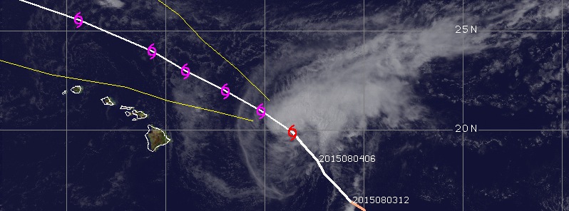
Tropical Storm "Guillermo" forecast track by JTWC on August 4, 2015. Image credit: JTWC/ACTF.
Total rainfall amounts of 2.5 to 7.6 cm (1 to 3 inches), with isolated maximum amounts near 17.8 inches (7 inches) mainly in higher terrain, are possible in the watch area.
Swells associated with Tropical Storm "Guillermo" will produce large surf along east facing shores of the main Hawaiian islands through much of the week.
Satellite animations
- Storm-Centered Infrared (GOES 15; NOAA/SSD)
- Storm-Centered Infrared (Aviation Color Enhancement) (GOES 15; NOAA/SSD)
- Storm-Centered Water Vapor (GOES 15; NOAA/SSD)
- Storm-Centered Visible (GOES 15; NOAA/SSD)
- Storm-Centered Visible (Colorized) (GOES 15; NOAA/SSD)
- Storm-Centered Infrared (GOES 15; CIMSS)
- Storm-Centered Enhanced Infrared (GOES 15; CIMSS)
- Storm-Centered Water Vapor (GOES 15; CIMSS)
- Storm-Centered Visible (GOES 15; CIMSS)
- Tropical East Pacific Infrared (GOES 15; NOAA)
- Tropical East Pacific Infrared (Aviation Color Enhancement) (GOES 15; NOAA)
- Tropical East Pacific Water Vapor (GOES 15; NOAA)
- Tropical East Pacific Visible (GOES 15; NOAA)
- Tropical East Pacific Visible (Colorized) (GOES 15; NOAA)
I'm a dedicated researcher, journalist, and editor at The Watchers. With over 20 years of experience in the media industry, I specialize in hard science news, focusing on extreme weather, seismic and volcanic activity, space weather, and astronomy, including near-Earth objects and planetary defense strategies. You can reach me at teo /at/ watchers.news.
Commenting rules and guidelines
We value the thoughts and opinions of our readers and welcome healthy discussions on our website. In order to maintain a respectful and positive community, we ask that all commenters follow these rules.