
Europe’s latest geostationary weather satellite – MSG-4 – delivers first image of Earth
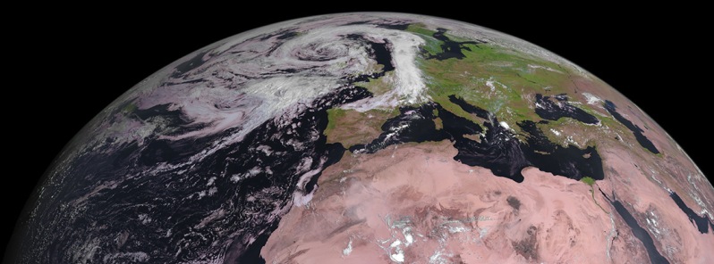
Image credit: EUMETSAT.
Following the successful launch of Europe's latest Meteosat Second Generation weather satellite, MSG-4, on July 15, 2015, the new satellite has captured and delivered its first image of Earth today.
After the satellite was moved into geostationary orbit, the various components which make up the its platform were activated and their functionality was checked. This included a number of critical maneuvers like the firing of the apogee motors, the change of spacecraft orientation and the unlocking of the SEVIRI (Spinning Enhanced Visible and Infrared Imager) scan mirror.

EUMETSAT took control of the satellite on July 26 and will now begin commissioning the satellite and its sensors. Commissioning consists of a two-month phase of satellite check-out and assessment, followed by four-months for imaging and product testing, including calibration and validation. After commissioning, MSG-4 will be stored in orbit.
The Watchers team and our contributors bring the latest on extreme weather, earthquakes, volcanic eruptions, space weather, and all things science. We're all about making sense of the natural world and keeping you informed on what’s happening. Got a tip or a question? Hit us up using the form at newstips!
Commenting rules and guidelines
We value the thoughts and opinions of our readers and welcome healthy discussions on our website. In order to maintain a respectful and positive community, we ask that all commenters follow these rules.