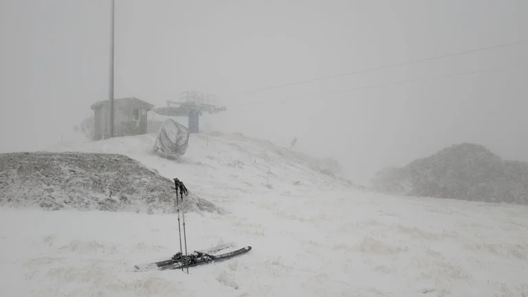
• Severe Tropical Cyclone Narelle to pass close to the North West Cape, bringing destructive winds to Western Australia

    Severe Tropical Cyclone Narelle strengthened to Category 4 off the coast of Western Australia on March 26, 2026, and was forecast to pass close to the North West Cape before tracking south along the Gascoyne coast on March 27. The Bureau of Meteorology warned the system could bring very destructive wind gusts up to 275 km/h (171 mph), dangerous storm surge, and heavy rainfall capable of producing flash flooding across parts of the Pilbara and Gascoyne.

  • Heavy rainfall and flooding impact Northern Territory as ex-Tropical Cyclone Narelle moves west

    Heavy rainfall from ex-Tropical Cyclone Narelle triggered flooding across parts of the Northern Territory, Australia, between March 21 and 23, 2026, inundating properties, disrupting infrastructure, and prompting evacuations. As of March 23, the system was moving west across the Kimberley and had a high chance of redeveloping into a tropical cyclone over waters off Western Australia by March 25, with further strengthening forecast. Severe weather was expected to continue across northern Kimberley through March 24.

  • Tropical Cyclone Narelle weakens after Queensland landfall, forecast to re-intensify over Gulf of Carpentaria

    Tropical Cyclone Narelle made landfall over the Queensland coast at 07:00 AEST on March 20 (21:00 UTC on March 19), as a high-end Category 4 system after briefly reaching Category 5 intensity a day earlier. The cyclone crossed the coast approximately 75 km (47 miles) south of Lockhart River, weakened to Category 2 by the afternoon, and began moving offshore toward the Gulf of Carpentaria. Destructive winds, heavy rainfall, and coastal flooding were reported across affected areas.

  • Category 5 Severe Tropical Cyclone Narelle forecast to cross Far North Queensland on March 20

    Severe Tropical Cyclone Narelle intensified into a Category 5 system on March 19, 2026, and is forecast to cross the Cape York Peninsula between Lockhart River and Cape Melville, Queensland, on the morning of March 20. Very destructive wind gusts of more than 250 km/h (155 mph), heavy rainfall of 100 to 350 mm (4 to 14 inches), and dangerous coastal conditions including abnormally high tides and large waves are forecast near and south of the landfall area, although slight weakening to a high-end Category 4 before crossing remains possible.

  • Severe Tropical Cyclone Narelle forecast to briefly reach Category 5 before Queensland landfall, Australia

    Severe Tropical Cyclone Narelle is forecast to intensify to Category 5 peak intensity over the Coral Sea before approaching the Far North Queensland coast between Lockhart River and Cooktown on March 20, 2026. Destructive winds of over 250 km/h (155 mph), along with rainfall totals over 350 mm (14 inches), are expected to triggere flash flooding, significant storm surges, and coastal flooding.

  • Tropical Cyclone Narelle forms in Coral Sea, forecast to intensify before Queensland impact, Australia

    ropical Cyclone Narelle developed in the northern Coral Sea on Tuesday, March 17, 2026, with sustained winds of 85 km/h (53 mph) and gusts to 120 km/h (75 mph). The system is moving west-southwest toward Far North Queensland and is forecast to intensify to severe tropical cyclone strength before approaching the coast later this week, with damaging winds, heavy rainfall, and coastal flooding being forecast.

  • Severe flooding hits Northern Territory and Queensland as rivers reach major levels, Australia

    Severe flooding affected parts of Northern Territory and Queensland, Australia during the first week of March 2026 after persistent monsoonal rainfall caused multiple rivers to exceed major flood levels. The Katherine River in Northern Territory peaked at 19.2 m (63 feet) before midnight on March 7, its highest level since 1998, while the Burnett River in Bundaberg, Queensland was forecast to reach about 7.6 m (25 feet) between March 10 and March 11, 2026. Evacuations, road closures, infrastructure disruptions, and widespread flood warnings were issued as rainfall totals exceeded 500 mm (20 inches) in parts of northern Australia.

  • Effusive activity and ash to 7.3 km (24 000 feet) at Big Ben volcano, Heard Island, Indian Ocean

    Satellite observations show that Heard Island’s Big Ben volcano remains active, with lava flows detected through late January and February 2026. The Darwin VAAC reported that the ash plume from a brief eruption around 14:00 UTC on February 11 reached 7.3 km (24 000 feet) above sea level and fully dissipated by the following day.