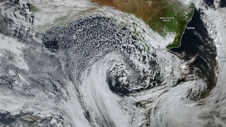
Sydney battered by heavy rain, leading to flash floods and rescues, Australia
Torrential downpours caused flash floods in Australia’s largest city, Sydney, on June 7, 2024, leading to evacuations and rescues in low-lying areas.
Sydney, Australia recorded 142.6 mm (5.6 inches) of rain on June 1 and 2, 2024, surpassing its June average of 132 mm (5.2 inches) in just one day and marking its second wettest June day on record.
Category 3 Tropical Cyclone “Megan” made landfall near Borroloola, the southwestern Gulf of Carpentaria coast, at approximately 06:00 UTC on March 18, 2024. At the time of the landfall, the system had a minimum pressure of 976.1 hPa and 1-minute sustained winds of 185 km/h (115 mph). Megan is the 5th named storm of the 2023/24 Australian region cyclone season.
Tropical Cyclone “Megan” formed on March 16, 2024, in the Gulf of Carpentaria as the 5th named storm of the 2023/24 Australian region cyclone season. Megan has reached Category 3 intensity today and is forecast to cross the southwest coast of the Gulf of Carpentaria, most likely on Monday, March 18, with wind gusts up to 220 km/h (137 mph).
Extremely heavy rains have struck Western Australia over the past couple of days, causing significant flooding that has severed the main route connecting Western Australia with the rest of the country. The flooding has also left seven people missing since Sunday, March 10, 2024.
Australian authorities called for the evacuation of tens of thousands in the southeast, including Victoria, on Wednesday, February 28, 2024, due to an intense heat wave exacerbating bushfire risks, marking the region’s severest conditions in four years.
An emergency warning has been issued for 28 communities west of Ballarat, Victoria, as residents are urged to evacuate due to an out-of-control bushfire. The fire, which ignited along Bayindeen-Rocky Road, is being fought by 1 000 firefighters with support from 24 aircraft and 100 vehicles.
Severe storms hit NSW, Australia on February 19, 2024, causing injuries, transport shutdown, and flash flooding. The storms have resulted in four people injured by a lightning strike, significant transport disruptions, and the ignition of three houses. Sydney recorded up to 57 mm (2.24 inches) of rain, intensifying the risk of flash flooding across the state.
Violent thunderstorms struck Australia’s east coast on February 13, 2024, leading to significant damage and disruptions. The storms caused the shutdown of AGL’s Loy Yang A power station in Victoria, leaving approximately 590 000 homes and businesses without electricity. The Australian Energy Market Operator (AEMO) was forced to cap electricity prices at A$16,600 per megawatt hour, a significant increase from the usual A$200. Efforts to restore power are ongoing, with some customers already reconnected.
Tropical Cyclone “Kirrily” made landfall on the Queensland coast at 22:00 local time (11:00 UTC) on January 25, 2024, with maximum sustained winds of 143 km/h (89 mph) — Category 2 cyclone on the Australian scale.