
Typhoon Sinlaku forecast to reach super typhoon strength before nearing the Marianas, Typhoon Warnings issued for Rota, Tinian and Saipan
Typhoon Sinlaku intensified into a dangerous major typhoon over the western Pacific on April 12, 2026, as officials issued typhoon warnings for Rota, Tinian and Saipan, and a tropical storm warning for Guam. The storm was forecast to strengthen further on April 13, reaching super typhoon strength, before nearing the Marianas, where destructive winds, coastal inundation, and flash flooding are possible from late April 13 into April 14.

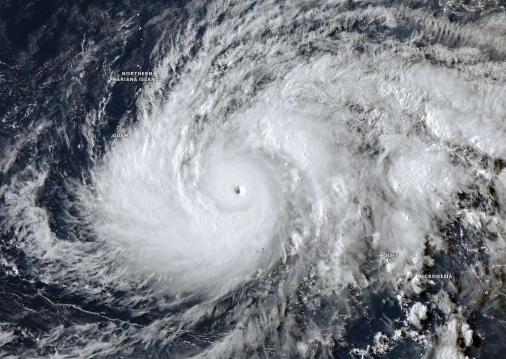
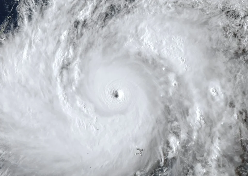
Satellite image of Typhoon Sinlaku at 06:20 UTC on April 12, 2026. Credit: JMA/Himawari-9, Zoom Earth, The Watchers
- Sinlaku is forecast to reach super typhoon strength on April 13 before nearing the Marianas.
- Typhoon warnings are in effect for Rota, Tinian and Saipan, with Guam under a tropical storm warning.
- Destructive winds, flash flooding and coastal inundation are possible from late April 13 into April 14.
At 04:00 UTC (14:00 ChST) on April 12, the center of Typhoon Sinlaku was located about 870 km (540 miles) east-southeast of Guam. The system was moving north-northwest at 15 km/h (9 mph), with sustained winds of 205 km/h (125 mph), according to the National Weather Service (NWS) office in Guam.
The warning area includes Rota, Tinian and Saipan under typhoon warnings, Guam under a tropical storm warning and continuing typhoon watch, and Pagan and Alamagan under tropical storm watches. Flood watches remain in effect across Guam and the Northern Mariana Islands, while a coastal flood watch is in effect beginning Monday morning for possible coastal inundation of 0.6 m (2 feet) or more.
The Joint Typhoon Warning Center (JTWC) assessed Sinlaku at 205 km/h (127 mph) at 03:00 UTC on April 12 and said environmental conditions remained highly favorable for additional strengthening. Vertical wind shear was low at 0-9 km/h (0-5 mph), sea surface temperatures were 28-29°C (82-84°F), and upper-level outflow remained strong.
JTWC forecast Sinlaku to reach peak sustained winds of about 240 km/h (149 mph) around April 13, which would place the cyclone at super typhoon strength under western North Pacific classification.
Slight weakening is forecast afterward, but Sinlaku is still expected to remain a large and dangerous major typhoon as it approaches the Marianas late April 13 into April 14.
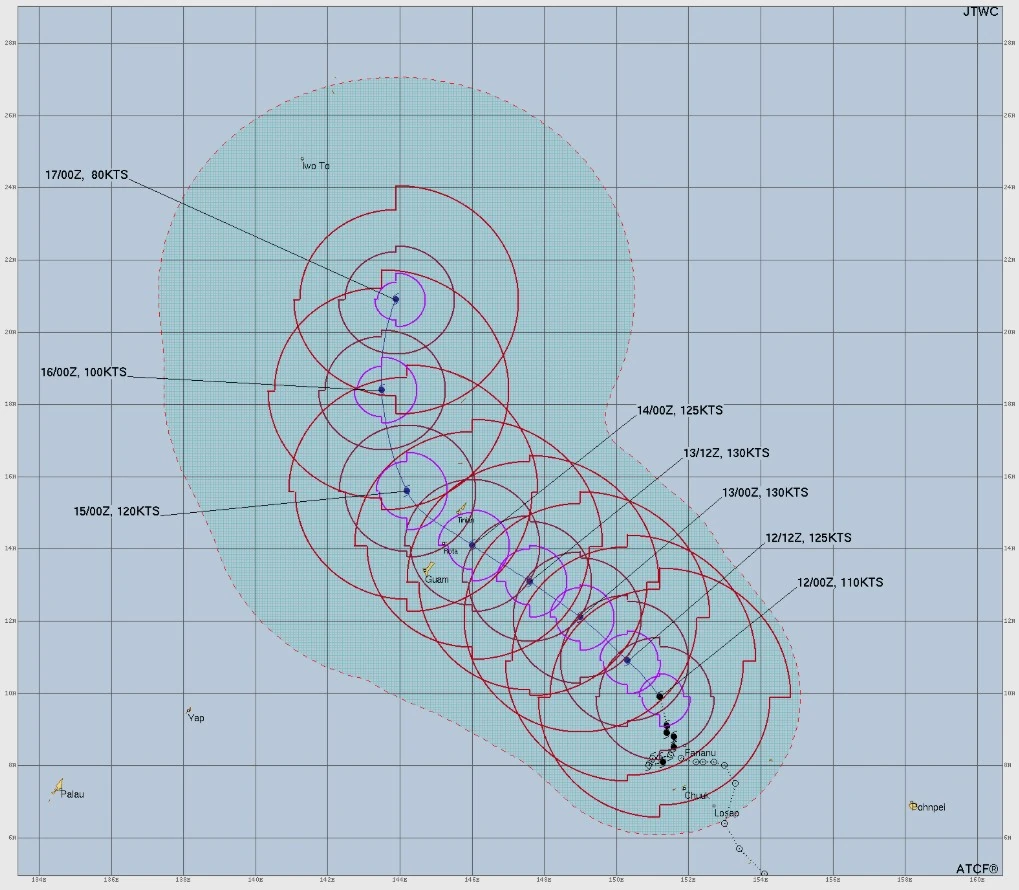
Forecast guidance shifted the storm track farther north over the past 24 hours, increasing concern for a passage between Rota and Saipan. However, even small shifts in the final track could significantly alter which islands receive the eyewall and strongest winds.
Tropical-storm-force winds are forecast to begin affecting Guam late Monday afternoon local time, with typhoon-force winds possible over Rota, Tinian and Saipan by Tuesday morning.
The NWS said Sinlaku still has the potential to cross the Marianas as a Category 3 or 4-equivalent typhoon, raising the possibility of extensive damage somewhere in the Northern Marianas.
Heavy rainfall associated with Sinlaku is expected through much of the week, with totals of 380-510 mm (15-20 inches) possible near the storm’s core. Forecasters warned that flash flooding, rapid runoff and landslides could develop, especially where rain bands stall over mountainous terrain.
Hazardous surf is expected to build to about 4.6 m (15 feet) across north-, east- and south-facing reefs, with dangerous coastal conditions likely to expand to west-facing shores after the storm passes west of the islands.
Additionally, elevated astronomical tides and storm surge may produce coastal inundation, beach erosion, and prolonged dangerous surf conditions into the second half of the week.
Authorities urged residents in the warning areas to complete preparations immediately.
Recommended actions include securing outdoor objects, boarding or shuttering windows, reinforcing doors, preparing emergency kits with medicines, food, water, flashlights and radios, and moving to safer shelter if directed by local officials or if living in flood-prone or vulnerable housing.
References:
1 Typhoon Sinlaku Warning #13 – JTWC – Issued at 03:00 UTC on April 12, 2026
2 Typhoon Sinlaku (04W) Local Statement – NWS/Tiyan GU – Issued at 15:56 ChST on April 12, 2026
I'm a dedicated researcher, journalist, and editor at The Watchers. With over 20 years of experience in the media industry, I specialize in hard science news, focusing on extreme weather, seismic and volcanic activity, space weather, and astronomy, including near-Earth objects and planetary defense strategies. You can reach me at teo /at/ watchers.news.
Commenting rules and guidelines
We value the thoughts and opinions of our readers and welcome healthy discussions on our website. In order to maintain a respectful and positive community, we ask that all commenters follow these rules.