
Atmospheric river makes landfall in California, up to 250 mm (10 inches) of precipitation forecast for Sierra Nevada
An atmospheric river made landfall over California during the afternoon of January 2, 2026. Heavy precipitation and mountain snow are forecast through early next week across central and northern California.
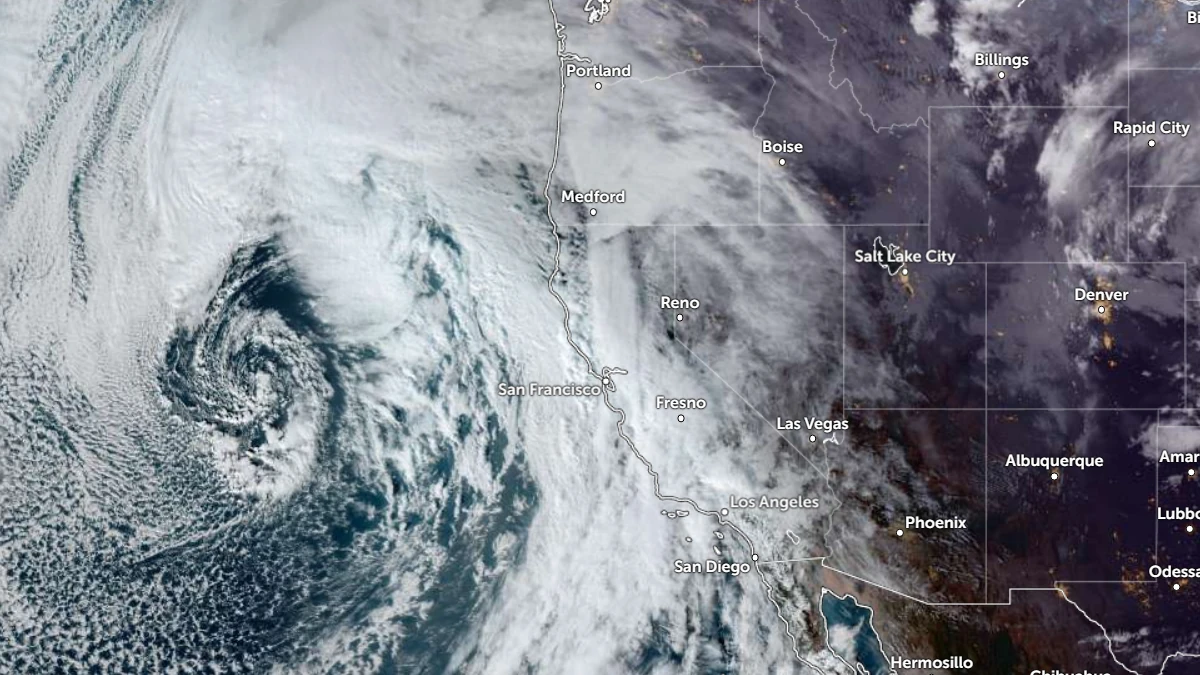
Satellite image of the atmospheric river moving over the California Coast as of 23:20 UTC on January 2, 2025. Credit: NOAA/GOES-19, Zoom Earth, The Watchers
An atmospheric river (AR) that developed near a deep mid-level trough within a plume of subtropical moisture made landfall over California on January 2. The system will bring heavy precipitation and high-elevation snowfall across much of the state through early next week.
Forecast models from the Center for Western Weather and Water Extremes (CW3E) suggest moderate AR conditions, with integrated vapor transport (IVT) values of over 500 kg m-1 s-1 along much of the California coast.
The CW3E West-WRF ensemble AR landfall tool shows more than 80% probability of AR conditions persisting through late January 3.
The strongest AR intensity is forecast to reach AR2 to AR3 levels over coastal southern Oregon, northern California, and central California


72-hour precipitation totals of 180–250 mm (7–10 inches) are forecast for the Klamath Mountains and northern Sierra Nevada. The Central and Southern Sierra Nevada and Coast Ranges are forecast to receive 100–200 mm (4–8 inches), while 75–125 mm (3–5 inches) is expected in the Transverse Ranges.
The Weather Prediction Center (WPC) issued a Slight Risk (level 2 of 4) Excessive Rainfall Outlook (ERO) for January 3–4 over the northern Sierra Nevada and Transverse Ranges.
Marginal Risk (level 1 of 4) EROs are in effect for the Klamath Mountains, Coast Ranges, Transverse Ranges, northern Sacramento Valley, and Sierra Nevada between January 2 and 6.

15 river gauges are forecast to reach action or monitor stages over the next five days, according to the California–Nevada River Forecast Center (CNRFC).
Freezing levels are forecast to drop from 2 400–3 000 m (8 000–10 000 feet) to 1 500–2 100 m (5 000–7 000 feet) across the Sierra Nevada during the weekend, allowing for significant snowfall at higher elevations.

Ensemble and subseasonal guidance suggests a transition toward a drier pattern across the U.S. West Coast during the second week of January. Forecast confidence remains high for reduced atmospheric river activity in that period.
References:
1 Quick Look at the AR Forecast to Impact California through this Weekend – CW3E – January 2, 2026

I am an Assistant Editor and Severe Weather & Science Journalist at The Watchers, specializing in real-time severe weather coverage, geophysical event reporting, and research-driven scientific analysis. You can reach me at rishav(at)watchers(.)news.
That looks like a hurricane to me.
Why are they hurricanes on the east coast but not the west coast?
That’s because the Pacific waters on the U.S. West Coast are much colder compared to the Atlantic Ocean on the east.
Hurricanes can only form and maintain their tropical characteristics in ocean waters with average temperatures of around 27°C/80°F . Waters near the West Coast hardly ever get that warm; even on a hot summer day, the only place where the ocean water could possibly be that warm on the West would be near the immediate coast.
Another reason is the northeasterly trade winds and westerlies that drive hurricanes toward the east coast and away from the west coast. The hurricanes that you do see forming near the western end of the USA form much lower in Mexico due to the interaction of the southeasterly and northeasterly trade winds.