
Eruption at Svartsengi could begin with very little warning, Iceland
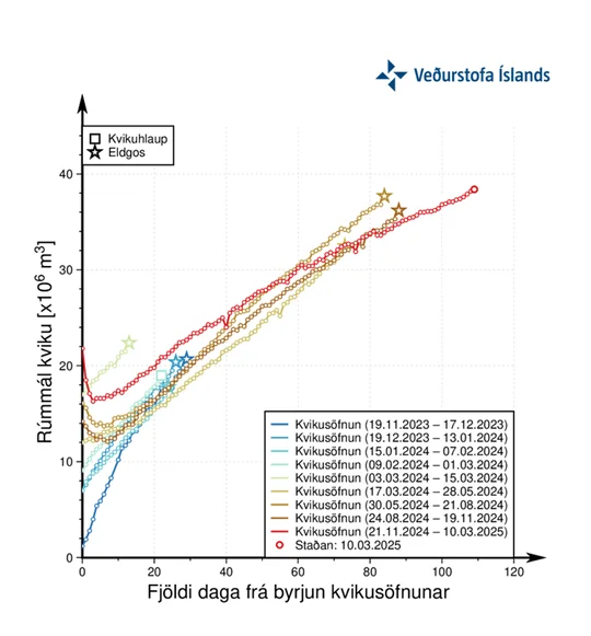
Magma accumulation beneath Svartsengi has reached its highest recorded level since the beginning of the ongoing eruption series in December 2023. The volume of magma beneath Svartsengi is now greater than what was recorded before the November 2024 eruption.

Image credit: Rúv – Jónmundur
Magma accumulation beneath Svartsengi has reached its highest recorded level since the beginning of the ongoing eruption series in December 2023. The volume of magma is now greater than what was recorded before the November 2024 eruption, suggesting that the next eruption could release a greater amount of lava.
Three months have passed since the last eruption, which lasted 18 days and ended on December 8, 2024. This marks the longest period of magma accumulation observed during the current eruption cycle at the Sundhnúkur crater row. The size of the eruption will depend on the volume of magma released from the chamber at the time of the event.
Land uplift continues at a steady rate, indicating that pressure is building within the magma chamber. A dike intrusion and subsequent eruption remain the most likely outcomes, with little to no warning before magma reaches the surface, according to the Icelandic Meteorological Office (IMO).
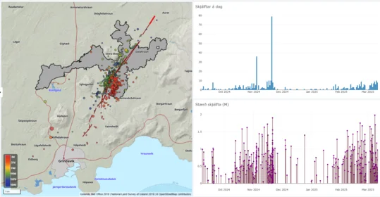
Seismic data indicates that recent earthquake activity is concentrated slightly further east compared to the seismic pattern leading up to the November 2024 eruption. The tremors are believed to be tectonic in origin, triggered by increased pressure in the crust because of ongoing magma accumulation. Further analysis of seismic data is underway to determine whether this shift in earthquake location is linked to a potential new eruption site.
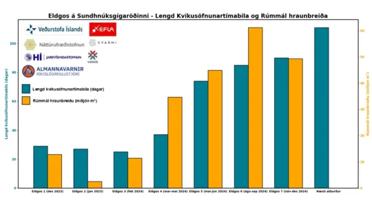
Graphs released by IMO depict the volume of accumulated magma beneath Svartsengi and the duration of magma accumulation phases before previous eruptions. The data shows a trend of increasing time between eruptions, with each event varying in size depending on the extent of magma intrusion.
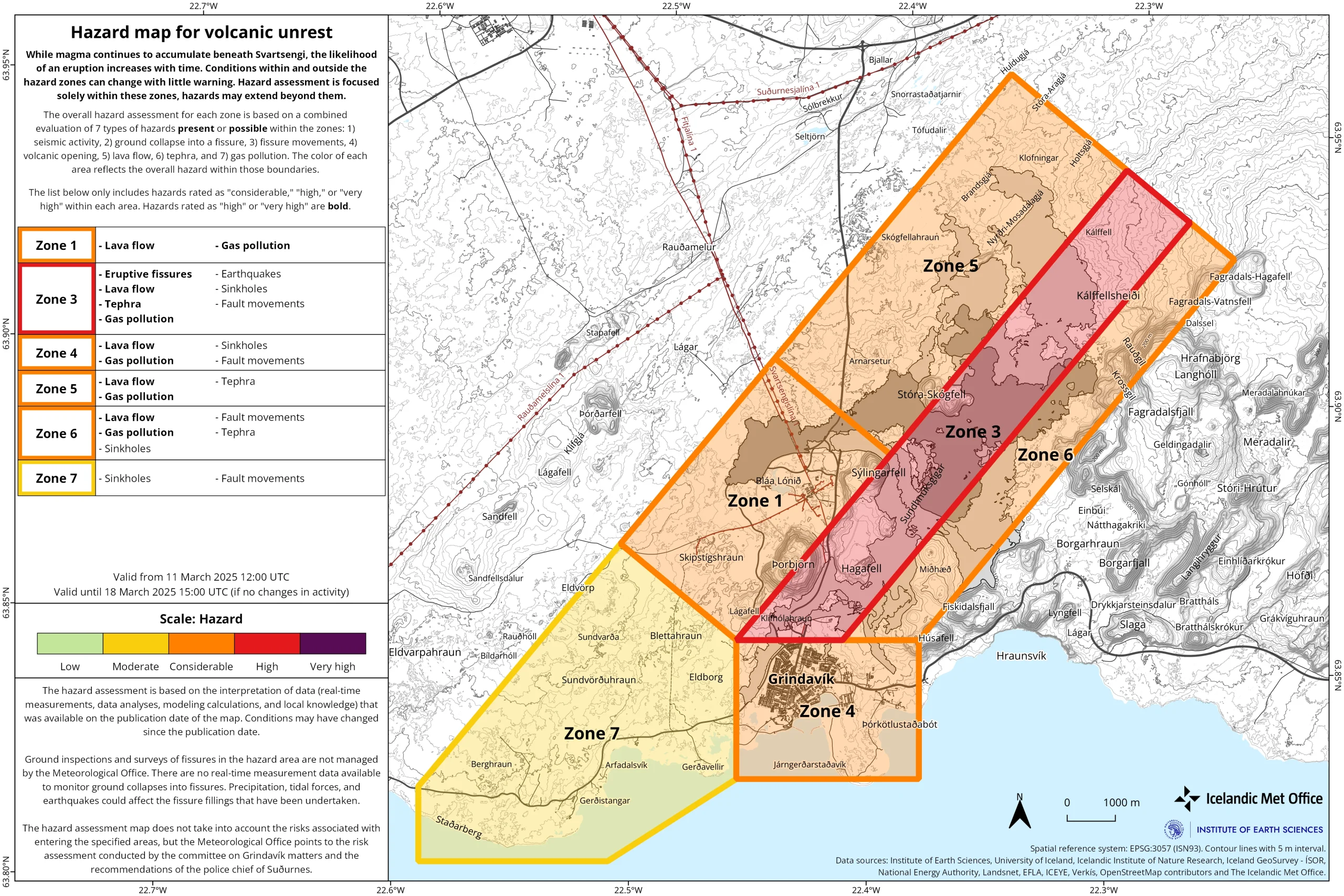
The current hazard assessment is valid until March 18, 2025. The risk level has increased in three areas. The hazard in Area 1 (Svartsengi) and Area 5 has been raised from “moderate” (yellow) to “considerable” (orange). The hazard in Area 3, the Sundhnúkur crater row, has been raised from “considerable” (orange) to “high” (red).
Signs of magma approaching the surface include intense small earthquake swarms in the Sundhnúk crater series, pressure changes in HS Orka’s boreholes in Svartsengi, fiber optic cable deformations, and real-time surface deformations recorded by GPS measurements.
If an eruption occurs, magma is most likely to emerge between Sundhnúkur and Stóra-Skógfell, as seen in six of the seven eruptions since 2023. The exception was in January 2024, when magma first emerged south of Hagafell.
The severity and reach of an eruption will depend on whether the volcanic fissures extend north or south. If an eruption occurs in an unfavorable wind direction, gas pollution could pose hazards within a 1 km (0.62 miles) radius. Lava could reach Grindavíkurvegur at Þorbjörn and/or Svartsengi beyond current defenses in under 1.5 hours.
If lava encounters groundwater or flows into water bodies, localized explosive activity could occur. An eruption south of or near Hagafell could result in lava reaching Nesvegur and Suðurstrandarvegur within 1.5 hours. If lava flow is extensive, it could block all land escape routes from Grindavík in approximately 6 hours.
The Reykjanes volcanic system, located at the southwestern tip of the Reykjanes Peninsula, is part of a neovolcanic rift zone where the Mid-Atlantic Ridge emerges above sea level. It consists of basaltic crater rows, shield volcanoes, and fissure vents.
Historical eruptions date back to the 12th century, with both subaerial and submarine eruptions recorded. The most recent eruption at Sundhnúkur, which began on November 20, 2024, lasted 18 days before ending on December 8, 2024. The system is known for repeated eruptive cycles and remains a focal point of geological research because of its active nature and location within the UNESCO-listed Reykjanes Global Geopark.
References:
1 Expectation of a New Eruption in the Sundhnúkur Crater Row is Ongoing – IMO – March 11, 2025
2 Reykjanes – GVP – Accessed on February 21, 2025

Rishika holds a Master’s in International Studies from Stella Maris College, Chennai, India, where she earned a gold medal, and an MCA from the University of Mysore, Karnataka, India. Previously, she served as a Research Assistant at the National Institute of Advanced Studies, Indian Institute of Science, Bengaluru, India. During her tenure, she contributed as a Junior Writer for Europe Monitor on the Global Politics website and as an Assistant Editor for The World This Week. Her work has also been published in The Hindu newspaper, showing her expertise in global affairs. Rishika is also a recipient of the Women Empowerment Award at the district level in Haryana, India, in 2022.
Commenting rules and guidelines
We value the thoughts and opinions of our readers and welcome healthy discussions on our website. In order to maintain a respectful and positive community, we ask that all commenters follow these rules.