
Flooding hits Washington and Oregon after atmospheric river landfall
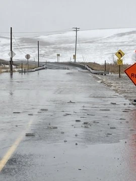
An atmospheric river that made landfall over the U.S. West Coast on Saturday, February 22, 2025, brought heavy rain and widespread flooding, particularly in Washington and Oregon, where multiple roads have been closed.

Flooding in Washington on February 23, 2024. Image credit: WSDOT
- An atmospheric river made landfall on the U.S. West Coast on Saturday, February 22, causing widespread flooding in Washington and Oregon.
- Several roads, including parts of I-90, have been closed due to floodwaters.
- Another storm system is forecast to arrive on Monday, February 24, bringing additional rain through the early week.
An atmospheric river (AR) made landfall on the U.S. West Coast on Saturday, February 22, bringing heavy precipitation across the Pacific Northwest, extending east through the northern Great Basin and the Rockies.
Areas across the West Coast, including parts of Washington and Oregon, are experiencing flooding, with some snow reported at higher elevations. Cities such as Seattle and Portland could face significant flooding due to heavy rainfall and strong winds associated with the AR.
Some areas have recorded over 25 mm (1 inch) of rainfall through Sunday, February 23, with rain expected to continue into the early part of the week. Rivers across Oregon and Washington are forecast to experience minor to major flooding.


The National Weather Service (NWS) reported that the Palouse River at Potlatch, Idaho, had reached flood levels by the early hours of Monday, February 24, standing at 5.21 m (17.1 feet).
Rising water levels have caused extensive lowland and field flooding between Potlatch Junction and Palouse, Washington. The NWS forecasts that the river will rise to 5.36 m (17.6 feet) before beginning to recede on Monday afternoon.
Minor flooding is forecast for the Siuslaw River in western Lane County and areas along Clackamas County in Oregon.
Several areas, including parts of I-90, I-5, and other key routes, have already reported flooding and road closures, with a few minor avalanches also occurring. Mud and debris on flooded roads have created hazardous travel conditions, prompting authorities to advise against travel in affected areas.
Rain and flooding are expected to continue through Monday into the early part of the week as another storm system moves in with additional moisture. Warmer Pacific air will keep snow levels high, leading to heavy rainfall in areas such as the Olympics, Coastal Ranges, and the Cascades.
The Weather Prediction Center (WPC) has issued a Slight Risk of Excessive Rainfall for Monday in affected regions due to the possibility of localized flooding on already saturated ground.
The storm will move eastward on Monday night, bringing rainfall to the northern Great Basin and Rockies, where runoff from melting snow and rain may cause additional flooding.
Snow levels will drop after a cold front passes, with some mixing of snow expected at lower elevations, though little accumulation is predicted. Significant snowfall is likely at high elevations, particularly in the northern Cascades and northern Rockies. Strong winds with gusts over 96 km/h (60 mph) are also anticipated. Conditions should begin to improve on Tuesday, February 25, with lighter and more scattered showers.
References:
1 Short Range Forecast Discussion – NWS/WPC – February 24, 2025

I am an Assistant Editor and Severe Weather & Science Journalist at The Watchers, specializing in real-time severe weather coverage, geophysical event reporting, and research-driven scientific analysis. You can reach me at rishav(at)watchers(.)news.
Commenting rules and guidelines
We value the thoughts and opinions of our readers and welcome healthy discussions on our website. In order to maintain a respectful and positive community, we ask that all commenters follow these rules.