
Long-duration atmospheric river impacts Washington and Oregon with heavy rain, snow and flood risk, U.S.
An atmospheric river made landfall in the Pacific Northwest during the morning of March 11, 2026, bringing heavy rain and snow across portions of Washington and Oregon. Forecasts show that the event will continue affecting the region through early March 14, producing significant precipitation totals, flooding concerns, and major winter weather impacts in mountainous terrain.

Satellite image of U.S. Pacific Northwest at 11:50 UTC on March 12, 2026. Credit: NOAA/GOES-19, Zoom Earth, The Watchers
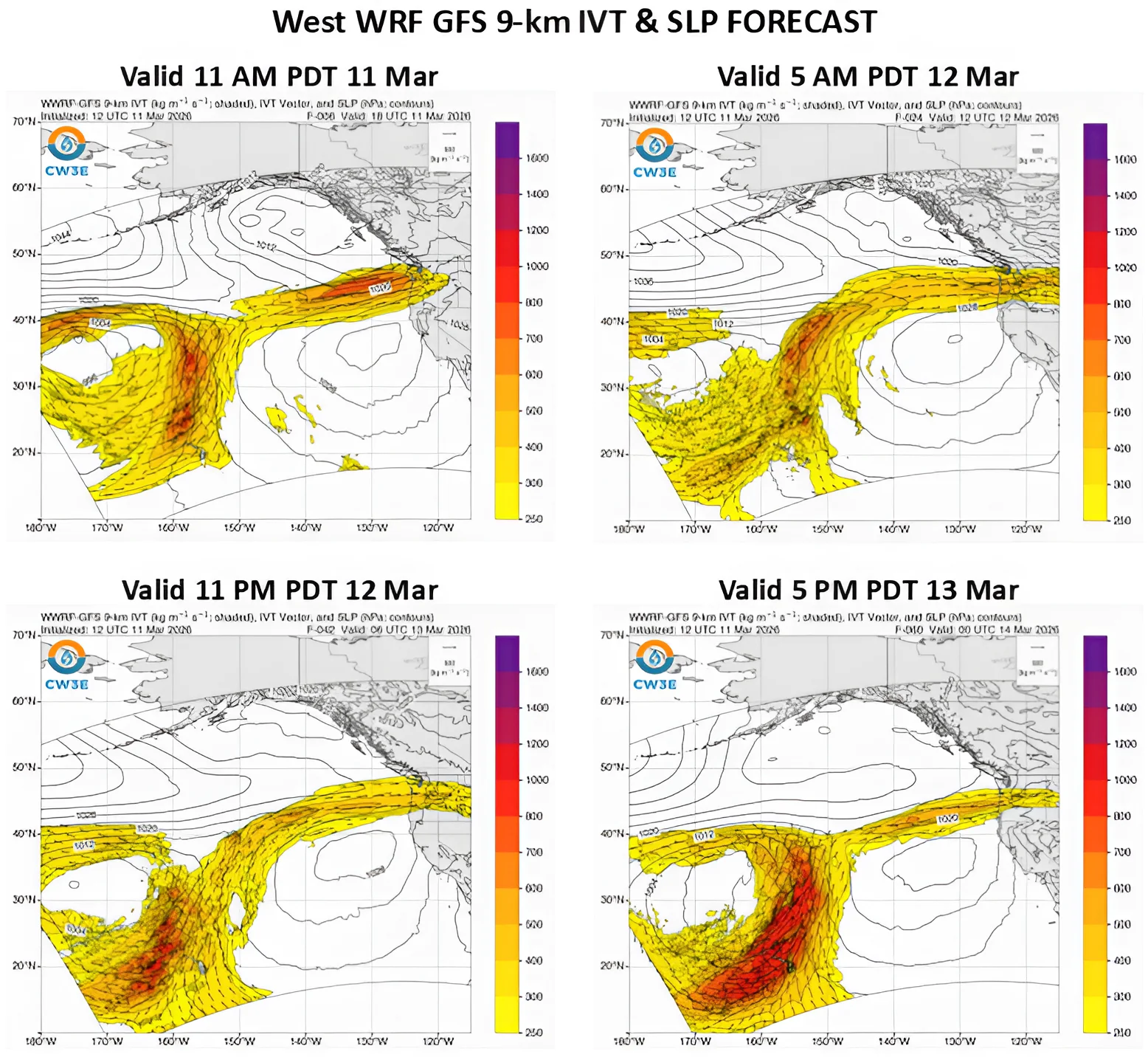
An atmospheric river (AR) made landfall across the Pacific Northwest during the morning hours of March 11, bringing widespread precipitation to portions of Washington and Oregon, United States.
Forecasts show a probability of over 90% for more than 60 hours of AR3 conditions across coastal southern Washington and coastal southern Oregon with localized AR4 conditions. Integrated vapor transport (IVT) values of over 250 kg m⁻¹ s⁻¹ are forecast during this period.
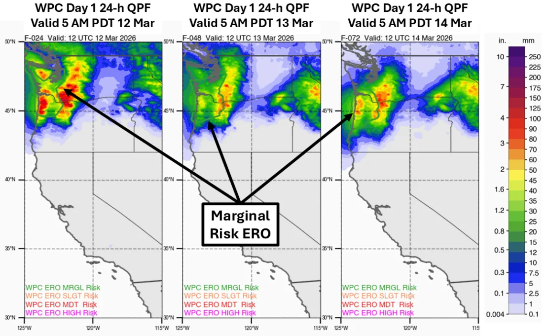
The National Weather Service (NWS) has issued marginal risk excessive rainfall outlooks for parts of western Washington and northwestern Oregon through early March 14. This outlook corresponds to at least a 5% probability of rainfall exceeding flash flood guidance due to multiple days of moderate to heavy precipitation.
The Weather Prediction Center (WPC) forecasts total accumulations of 100–180 mm (4–7 inches) across the northern Oregon Coast Range and the Cascades through early March 14. Localized totals of over 250 mm (10 inches) are possible at higher elevations in the Cascade Range.
Farther inland, the atmospheric river is forecast to penetrate into parts of northern Idaho and western Montana, where precipitation totals may reach up to 180 mm (7 inches) in higher terrain areas.
Freezing levels along the Washington Cascades are forecast to briefly rise above 1 500 m (5 000 feet) on March 11 before dropping below 600 m (2 000 feet) by March 12. This transition is expected to produce substantial snowfall accumulations and moderate to major winter weather impacts across higher elevations.
Snowfall totals of 90–180 cm (36–72 inches) are forecast across mountainous terrain in the Cascades, northern Idaho, and western Montana, with heavier totals in higher elevations. Blizzard Warnings and Winter Storm Warnings have been issued for the Olympic Mountains and Washington Cascades as a result of the expected conditions.
In Washington State, a Winter Storm Warning covers the Olympic Mountains, including Mount Olympus and Hurricane Ridge.
A Blizzard Warning remains in effect until 05:00 PDT March 12, followed by a Winter Storm Warning from 05:00 PDT March 12 to 05:00 PDT March 14. Snow accumulations of 30 to 90 cm (1 to 3 feet) are forecast across higher elevations, with wind gusts reaching 64 km/h (40 mph). Travel conditions may become very difficult or impossible due to blowing snow and low visibility.
Meanwhile, a Winter Storm Warning covers the Northern Blue Mountains, including areas near Tollgate and Meacham in Oregon.
The warning is in effect from 05:00 PDT March 12 until 17:00 PDT March 13 above elevations of 1 200 m (4 000 feet). Heavy snowfall between 20 and 38 cm (8 to 15 inches) is forecast, with wind gusts reaching 97 km/h (60 mph). Low visibility and snow-covered roads are expected to produce extremely dangerous driving conditions.
The Northwest River Forecast Center (NRFC) shows that approximately 20 river gauges are expected to exceed action or bankfull levels during the event. Two additional gauges near Portland, Oregon, are forecast to reach minor flood stage.
While there is a possibility of AR activity persisting past March 14, forecasts remain uncertain regarding the evolution of a second AR.
References:
1 Quick Look at the Atmospheric Rivers Forecast to Impact the Pacific Northwest – CW3E – March 11, 2026
2 Winter Storm Warning – NWS – March 12, 2026

I am an Assistant Editor and Severe Weather & Science Journalist at The Watchers, specializing in real-time severe weather coverage, geophysical event reporting, and research-driven scientific analysis. You can reach me at rishav(at)watchers(.)news.
Commenting rules and guidelines
We value the thoughts and opinions of our readers and welcome healthy discussions on our website. In order to maintain a respectful and positive community, we ask that all commenters follow these rules.