
Powerful atmospheric river drenches California, leaves at least 2 people dead and more than 300 000 customers without power, U.S.
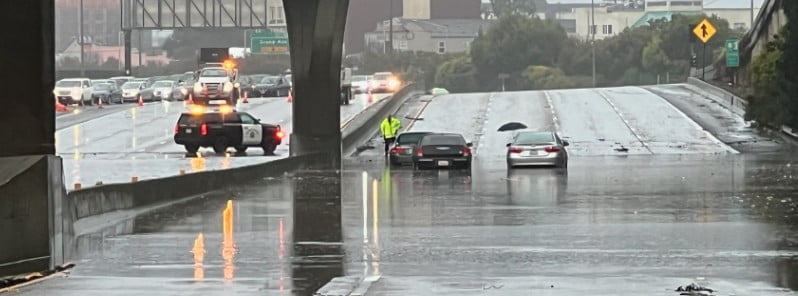
Image credit: CHP San Francisco
A powerful atmospheric river brought heavy rains to northern and central California on December 31, 2022, bringing widespread flooding and power outages. At least 2 people lost their lives.
- The storm left more than 300 000 customers without power across California and Nevada, trapped people in flooded vehicles, and prompted Sacramento County to warn some residents to evacuate ahead of an imminent levee failure
- The winter storm is now shifting over the Central and Southern U.S.
- More than 15 million people from the West Coast to Illinois are under winter weather alerts
The Sacramento County area was particularly hard hit over the past few days, with emergency crews spending the weekend rescuing multiple flood victims by boats and helicopter and responding to fallen trees and disabled vehicles in the flood waters, the Sacramento Metropolitan Fire District said.1
On Sunday, January 1, 2023, the Sacramento County Office of Emergency Services issued an evacuation warning to residents living in the areas of Point Pleasant, Glanville Tract, and Franklin Pond to prepare to leave the area before roadways are cut off to evacuate the area.
“It is expected that the flooding from the Cosumnes River and the Mokelumne River is moving southwest toward I-5 and could reach these areas in the middle of the night,” county officials said at 20:43 UTC on January 1, adding that livestock in the affected areas should be moved to higher ground.
By midnight UTC on January 2, the Point Pleasant area’s evacuation warning has been escalated to an Evacuation Order. “Flooding in the area is imminent,” officials said.
“Please gather your pets, important paperwork, prescriptions and all people in your household, and safely make your way to the Evacuation Center.”
Flooding from the Cosumnes River forced the closure of Highway 99 south of Elk Grove in Sacramento County, the California Department of Transportation said. SR 99 is one of the state’s heavily traveled, and commercially important, corridors.
Aerial video from CNN affiliate KCRA showed cars submerged past their door handles in flood waters from Highway 99 and the Dillard Street area. Chris Schamber, a fire captain with the Cosumnes Fire Department, told the station “dozens upon dozens” of people had been rescued.1
For San Francisco, the storm brought one of its wettest days in records and caused widespread flooding, temporarily closing one of California’s most famous routes – US Highway 101 – in both directions in San Francisco.
As of 17:00 LT on December 31, a weather station in downtown San Francisco registered 138.4 mm (5.45 inches) of rain, making it the second-wettest day in the area since records began in 1949. The current official record at the weather station is 140.7 mm (5.54 inches) set on November 5, 1994.
The city of Oakland recorded 120.6 mm (4.75 inches) of rain in 24 hours, breaking the previous record set on January 4, 1982.
Redwood City recorded 123.9 mm (4.88 inches), its third-greatest daily since 1906.
The storm brought impressive snow totals to mountainous areas of Northern California. Areas above 1 500 m (5 000 feet) received between 50 and 115 cm (20 – 45 inches) on December 31 and January 1.
Sierra Snow Lab registered a snowfall rate of 19 cm (7.5 inches) per hour between 16:00 and 17:00 LT on December 31.
In just 24 hours, the Sierra Snow Lab recorded 76 cm (29.9 inches), Sierra at Tahoe Ski Resort 106.7 cm (42 inches), Boreal Ski Resort and Soda Springs 101.6 cm (40 inches), and Bear Valley Ski Resort 53.3 cm (21 inches).
At least 2 people lost their lives, according to officials.
One person in southern Sacramento County was found dead inside a completely submerged vehicle on a roadway, while a 72-year-old man was killed after being struck by a fallen tree at a state park in Santa Cruz.
Multiple please in Sacramento were rescued by helicopters since December 31. At least one person was transferred to the hospital in critical condition after being washed off the roadway and being trapped in the cold water.
Winter storm shifting over the Central and Southern U.S.
The main weather story to start the new year continues to be with the impacts related to a storm system currently moving through the Rockies and forecast to intensify after it reaches the Plains, with a winter storm, flash flooding, and severe weather all expected, NWS forecaster Putnam noted.2
Divergence aloft ahead of an eastward-moving upper-level trough will help to enhance a deepening low pressure center, with a warm front pushing northward over the South and Midwest as a cold front pushes eastward over the Southern Plains and into the Lower Mississippi Valley.
A winter storm will start to ramp up later Sunday night in the colder air to the north and west of the surface low track across the Central Plains and eventually into the Upper Midwest with numerous winter weather-related advisories in effect.
There is still lingering uncertainty as to the exact surface low track and frontal features which will determine the distribution of precipitation types and amounts.
Currently, the axis of highest snow amounts between 15 – 30 cm (6 – 12 inches), locally higher, stretches from eastern Wyoming northeast through northwestern Nebraska, southern South Dakota, southern Minnesota, and northwestern Wisconsin.
The axis of freezing rain will track just to the southeast of the heavy snow axis, with the most significant ice accumulations of greater than 6 mm (0.25 inches) currently expected for northwestern Iowa and southern Minnesota.
Vigilance to the most recent forecast is important given the potential for heavy snow rates of 2.5 – 5 cm (1 – 2 inches) per hour and blowing snow, leading to significant travel impacts, and with the highest accumulations of freezing rain potentially leading to power outages.
References:
1 Epic flooding leads to water rescues and highway closures in California as the storm system threatens more states – CNN – January 1, 2022
2 Short Range Forecast Discussion – NWS Weather Prediction Center College Park MD – 339 PM EST Sun Jan 01 2023
I'm a dedicated researcher, journalist, and editor at The Watchers. With over 20 years of experience in the media industry, I specialize in hard science news, focusing on extreme weather, seismic and volcanic activity, space weather, and astronomy, including near-Earth objects and planetary defense strategies. You can reach me at teo /at/ watchers.news.
Commenting rules and guidelines
We value the thoughts and opinions of our readers and welcome healthy discussions on our website. In order to maintain a respectful and positive community, we ask that all commenters follow these rules.