
Hurricane “Helene” expected to bring catastrophic and deadly storm surge to Florida Big Bend, U.S.
Hurricane “Helene” is expected to rapidly intensify to a Category 4 major hurricane before making landfall on Florida’s Big Bend coast on Thursday, September 26, 2024. Catastrophic storm surge, potentially reaching 6 m (20 feet) above ground, along with destructive winds and life-threatening flash flooding, pose serious risks to the region. Residents in affected areas are urged to follow evacuation orders and complete preparations immediately.
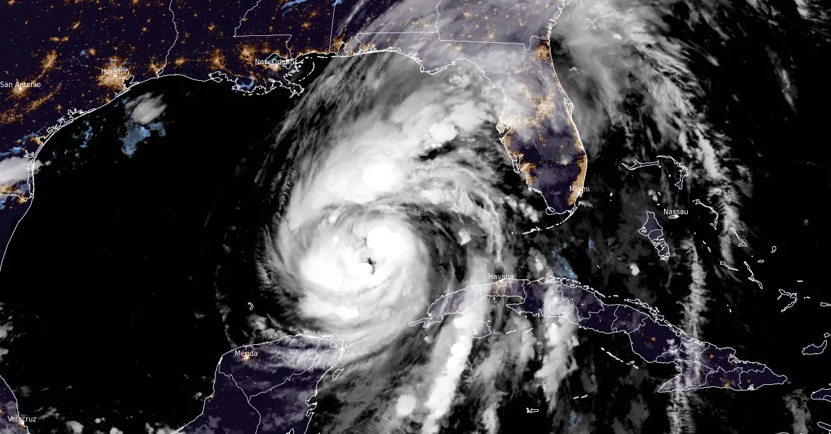
Satellite image of Hurricane "Helene" at 07:40 UTC on September 26, 2024. Image credit: NOAA/GOES-East, RAMMB/CIRA, The Watchers
- A catastrophic and deadly storm surge is likely along portions of the Florida Big Bend coast, with inundation potentially reaching up to 6 m (20 feet) above ground level, accompanied by destructive waves. There is also a significant risk of life-threatening storm surge along the remainder of the west coast of the Florida Peninsula. Residents in these areas should adhere to the guidance provided by local officials and evacuate if instructed to do so.
- Potentially catastrophic hurricane-force winds are expected within the eyewall of Hurricane “Helene” when it makes landfall in the Florida Big Bend region late on Thursday. Preparations to protect life and property should be completed by early Thursday before tropical storm conditions arrive. Damaging and life-threatening hurricane-force winds, particularly in gusts, are expected to penetrate well inland over portions of northern Florida and southern Georgia late Thursday and Thursday night, where Hurricane Warnings are in effect.
- Catastrophic and life-threatening flash flooding and urban flooding, including numerous landslides, are expected across parts of the southern Appalachians through Friday. Considerable to locally catastrophic flash flooding and urban flooding are likely for northwestern and northern Florida, as well as the Southeast, through Friday.
- Voluntary and mandatory evacuation orders are currently in effect in multiple counties across the state.
Hurricane “Hellene” — currently a Category 2 hurricane on the Saffir-Simpson Hurricane Wind Scale — is forecast to rapidly intensify before landfall, with the official forecast expecting it to reach Category 4 status.
This will make Helene a large major hurricane when it reaches the Big Bend coast of Florida on Thursday, September 26, 2024. As a result, storm surge, wind, and rainfall impacts will extend well away from the center and outside the forecast cone, particularly on the east side.
In addition, the fast forward speed when Helene moves inland will result in a far inland penetration of strong winds over parts of the southeastern United States, including strong gusts over higher terrain of the southern Appalachians.
At 06:00 UTC on September 26, Helene’s center was located about 620 km (385 miles) SW of Tampa and 680 km (425 miles) SSW of Apalachicola, Florida, U.S., according to the National Hurricane Center (NHC).
The system had maximum sustained winds of 140 km/h (12 mph) and a minimum central pressure of 971 hPa.
A Storm Surge Warning is currently in effect for areas from Mexico Beach eastward and southward to Flamingo, including Tampa Bay and Charlotte Harbor. Residents in these regions should be prepared for the possibility of life-threatening inundation from rising water levels caused by the storm.
Additionally, a Hurricane Warning has been issued for the area stretching from the Anclote River to Mexico Beach. This warning indicates that hurricane conditions are expected within the warning area, and preparations to protect life and property should be rushed to completion.
A Hurricane Watch is also in place for the region extending from Englewood to the Anclote River, including Tampa Bay. This watch means that hurricane conditions are possible within the watch area, generally within 48 hours.
Furthermore, a Tropical Storm Warning has been issued for several areas, including the Florida Keys, the Dry Tortugas, and from Flamingo to the Anclote River, including Tampa Bay. The warning also covers areas west of Mexico Beach to the Okaloosa/Walton County Line, from Flamingo northward to Little River Inlet, Lake Okeechobee, as well as the Cuban provinces of Artemisa, Pinar del Rio, and the Isle of Youth.
Helene is moving toward the north near 19 km/h (12 mph). A northward or north-northeastward motion at a faster forward speed is expected during the next 36 hours.
According to the NHC, Helene will move across the eastern Gulf of Mexico today and cross the Florida Big Bend coast this evening (LT). After landfall, Helene is expected to turn northwestward and slow down over the Tennessee Valley on Friday and Saturday.
Rapid strengthening is forecast, and Helene is expected to be a major hurricane when it reaches the Florida Big Bend coast this evening. Weakening is expected after landfall, but Helene’s fast forward speed will allow strong, damaging winds, especially in gusts, to penetrate well inland across the southeastern United States, including over the higher terrain of the southern Appalachians.

The combination of a life-threatening storm surge and the tide will result in normally dry areas near the coast being flooded by rising waters moving inland from the shoreline.
If the peak surge coincides with high tide, water levels could reach the following heights above ground in the indicated areas:
- Carrabelle, FL to Suwannee River, FL: 4.5 to 6 m (15 to 20 feet)
- Apalachicola, FL to Carrabelle, FL: 3 to 4.5 m (10 to 15 feet)
- Suwannee River, FL to Chassahowitzka, FL: 3 to 4.5 m (10 to 15 feet)
- Chassahowitzka, FL to Anclote River, FL: 2.5 to 3.5 m (8 to 12 feet)
- Indian Pass, FL to Apalachicola, FL: 2 to 3 ms (6 to 10 feet)
- Anclote River, FL to Middle of Longboat Key, FL: 1.5 to 2.5 m (5 to 8 feet)
- Tampa Bay: 1.5 to 2.5 m (5 to 8 feet)
- Middle of Longboat Key, FL to Englewood, FL: 1.2 to 2 m (4 to 7 feet)
- East of Mexico Beach, FL to Indian Pass, FL: 0.9 to 1.5 m (3 to 5 feet)
- Englewood, FL to Flamingo, FL: 0.9 to 1.5 m (3 to 5 feet)
- Charlotte Harbor: 0.9 to 1.5 m (3 to 5 feet)
Additionally, storm surge could elevate water levels by as much as 0.6 to 1.2 m (2 to 4 feet) above normal tide levels in areas with onshore winds along the southern coast of Pinar del Rio, Cuba, including the Isle of Youth.
Hurricane conditions are anticipated within the U.S. hurricane warning area late today, with tropical storm conditions expected to begin this morning. Southern Florida will experience tropical storm conditions this morning, which will spread northward across the rest of Florida, Georgia, and South Carolina throughout the night. In western Cuba, tropical storm conditions are expected over portions of the warning area within the next several hours.
Helene is forecasted to produce total rainfall accumulations of 100 to 200 mm (4 to 8 inches) over western Cuba, the Cayman Islands, and the northeastern Yucatan Peninsula, with isolated totals of around 300 mm (12 inches). This amount of rainfall poses a considerable risk of flooding.
In portions of the Southeastern U.S. and the Southern Appalachians, the hurricane is expected to bring total rainfall accumulations of 150 to 300 mm (6 to 12 inches), with isolated totals of up to 450 mm (18 inches). This heavy rainfall will likely lead to catastrophic and potentially life-threatening flash flooding, urban flooding, and significant river flooding. Numerous landslides are also anticipated in the steep terrain across the southern Appalachians.
A tornado or two may occur this morning in parts of Florida. The risk of tornadoes will increase later today, expanding northward across Florida into parts of Georgia and South Carolina.
Swells generated by Helene will affect the southern coast of Cuba and the Yucatan Peninsula of Mexico over the next couple of days. These swells will spread northward toward the west coast of Florida and the northeastern Gulf Coast today. These conditions are likely to cause life-threatening surf and rip currents.

On Wednesday, September 25, Florida Governor Ron DeSantis, alongside Florida Division of Emergency Management (FDEM) Executive Director Kevin Guthrie, visited Tampa to meet with power and utility linemen who are staged and ready to respond to power outages caused by Hurricane “Helene.” During the visit, the Governor also provided updates on the state’s preparedness efforts ahead of the storm’s landfall.
Following Governor DeSantis’ request, FEMA approved Florida’s pre-landfall disaster declaration request which now extends to 61 counties. This declaration allows state officials to allocate critical resources to communities in advance of any potential impacts from the storm.
Voluntary and mandatory evacuation orders are currently in effect in multiple counties across the state. Residents who are under a mandatory evacuation order should evacuate as soon as possible.
The Florida Division of Emergency Management (FDEM) has activated the State Emergency Operations Center to Level 1 and is leading coordination efforts with the State Emergency Response Team. FDEM is holding twice-daily calls with all 67 counties to identify needs and ensure a swift response. Additionally, FDEM is coordinating with state agencies, NGOs, and private sector partners to address resource requests, including water, generators, and support personnel. Over 800 missions are being facilitated by the State Emergency Response Team, including pre-staging resources, protecting critical infrastructure, and coordinating statewide personnel.
35 000 shelf-stable meals have been staged near the anticipated impact area, and seven Urban Search and Rescue task forces are ready for deployment. The Florida National Guard (FLNG) has mobilized nearly 3 500 Soldiers and Airmen, with the capacity to increase to 5 500 if necessary. The FLNG is focused on staging forces, assigning responsibilities, and placing liaison officers in affected counties, with readiness to provide logistics support, law enforcement, search and rescue, and flood mitigation. The Florida State Guard (FSG) has also prepared over 250 soldiers and various specialized equipment for deployment.
The Florida Department of Law Enforcement (FDLE) is coordinating law enforcement missions from the State Emergency Operations Center, moving and staging assets, and preparing for immediate response. FDLE has staged aircraft, portable towers for communications, and 10 squads of agents ready to respond. The Florida Fish and Wildlife Conservation Commission (FWC) has prepared high-water vehicles and storm response resources, staging equipment for rapid deployment, and preparing officers and specialized equipment to assist Floridians.
The Florida Department of Transportation (FDOT) has activated over 1 700 team members for storm response, suspended construction work on key evacuation routes, and staged heavy equipment, pumps, and generators. FDOT is analyzing flooding vulnerabilities and inspecting drainage systems, with Road Ranger services available 24/7 in certain districts. Seaports, airports, and railroads are open and monitoring the storm, with specific seaport and transit schedule modifications already in place. The Florida Department of Veterans’ Affairs (FDVA) has alerted its State Veterans’ Homes and is implementing hurricane preparation checklists.
Volunteer Florida is coordinating with partners to identify available assets, resource gaps, and staging locations, while the Florida Department of Management Services (FDMS) is identifying potential evacuation shelters. Health and human services agencies, including the Agency for Persons with Disabilities (APD) and the Florida Department of Health (DOH), are preparing for the storm by staging emergency response vehicles, coordinating with facilities, and ensuring adequate supplies of food, medicine, and emergency equipment. The Florida Department of Environmental Protection (DEP) has issued an Emergency Final Order to activate disaster debris management sites and expedite repairs to critical infrastructure.
The Florida Highway Patrol (FHP) is pre-staging assets for immediate response post-landfall, including high-water rescue vehicles and aviation assets. FHP is supporting evacuation efforts and coordinating with law enforcement and transportation agencies to ensure smooth traffic flow.
The Florida Department of Highway Safety and Motor Vehicles (FLHSMV) has issued an emergency order to waive certain requirements for commercial motor vehicles and provide relief to impacted residents. The Department of Children and Families (DCF) is preparing for the storm by securing supplies and contacting vulnerable populations, while the State Mental Health Treatment Facilities have activated disaster plans.
References:
1 Hurricane Helene Intermediate Advisory Number 11A – NWS/NHC – Issued at 06:00 UTC on September 26, 2024
2 Hurricane Helene Discussion Number 11- NWS/NHC – Issued at 03:00 UTC on September 26, 2024
3 Governor Ron DeSantis Issues Updates on State Preparedness Efforts Ahead of Hurricane Helene – Florida Government – September 25, 2024
I'm a dedicated researcher, journalist, and editor at The Watchers. With over 20 years of experience in the media industry, I specialize in hard science news, focusing on extreme weather, seismic and volcanic activity, space weather, and astronomy, including near-Earth objects and planetary defense strategies. You can reach me at teo /at/ watchers.news.
Commenting rules and guidelines
We value the thoughts and opinions of our readers and welcome healthy discussions on our website. In order to maintain a respectful and positive community, we ask that all commenters follow these rules.