
Debby leaves 8 dead, heavy rainfall and significant flood threats continue in parts of Mid-Atlantic and Northeast

Image credit: NASA/GSFC
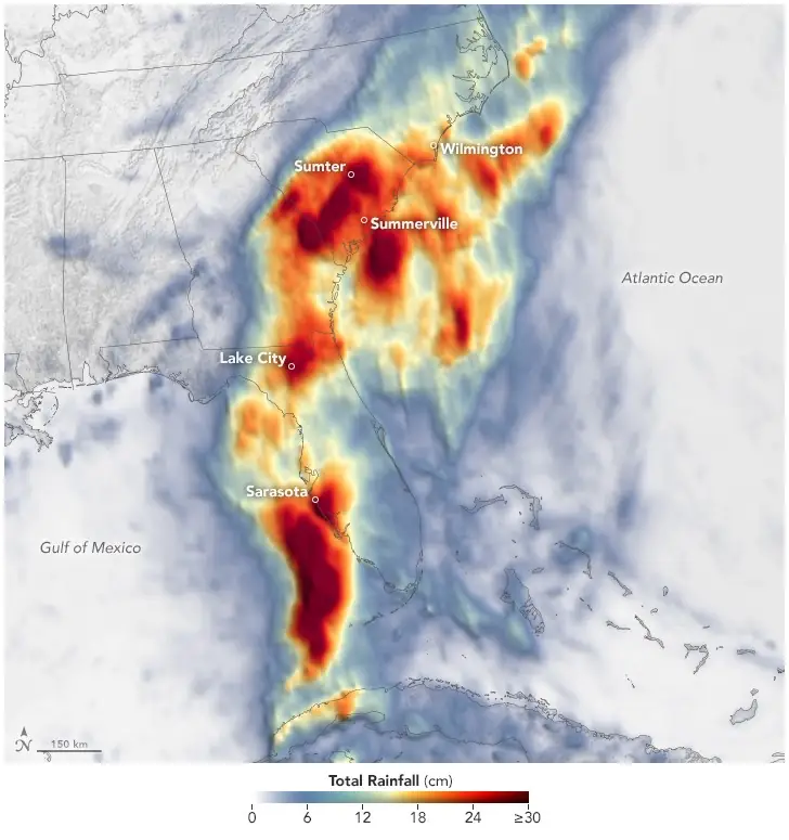
Category 1 Hurricane “Debby” made landfall near Steinhatchee in Florida’s Big Bend at 11:00 UTC on Monday, August 5, 2024, and continued moving inland, dropping heavy rains. As Debby moved offshore and then back inland, it continued to gather moisture, leading to a second landfall northeast of Charleston, South Carolina, on August 8.
- National Weather Service Doppler radar at 14:00 UTC (10:00 EDT) today indicated bands of moderate to heavy rainfall in Pennsylvania, New York, and portions of New England.
- Light to moderate rainfall continues to linger in portions of northern Virginia, Maryland, and New Jersey.
- Debby is also producing gusty winds along the Mid-Atlantic and Northeast.
- As of August 9, the system is blamed for the deaths of 8 people.
Debby is now a post-tropical cyclone and is still producing gusty winds, heavy rains and flash flooding throughout much of the Mid-Atlantic and Northeast.
Over a five-day period ending at 14:00 UTC on August 8, this system dropped large amounts of rain across Florida, Georgia, and the Carolinas.
In Florida, the highest amount was registered in Lake City at 499.6 mm (19.67 inches), followed by 479 mm (18.86 inches) in Parrish, 465.8 mm (18.34 inches) in Lakewood Ranch, and 451.7 mm (17.78 inches) in Sarasota.
The highest amount in South Carolina was registered in Summerville at 463.6 mm (18.25 inches), followed by 449.6 mm (17.7 inches) in Mount Pleasant and 442.9 mm (17.43 inches) in Green Pond.
Georgia saw the highest rainfall amount in Oliver at 376.4 mm (14.82 inches), followed by Rincon at 352.3 mm (13.87 inches), while in North Carolina, King Grand registered 387.4 mm (15.25 inches), followed by Shallotte at 331.6 mm (13.05 inches).

Bladenboro, North Carolina, was particularly hard hit, with severe flooding that blocked all roadways into the town and emergency management issuing a voluntary evacuation for the area.
A tornado in Lucama, North Carolina, leveled homes, damaged Springfield Middle School and claimed one life when a house collapsed during the storm. Stephen Mann, director of communications for Wilson County, confirmed the fatality.
The death toll from Debby reached 8 on Friday, August 9, with six fatalities occurring due to traffic accidents or fallen trees, and another in Gulfport, Florida, where a 48-year-old man was found dead after his anchored sailboat partially sank.
Further south, in Bladenboro, North Carolina, deputies reported near-miss incidents, including a large tree falling across Highway 87, narrowly avoiding two patrol cars.
The storm also left hundreds of thousands without power, particularly in Florida, where over 300 000 customers experienced outages at the storm’s peak. More than 1 000 flights had been canceled, including 8% of the American Airlines flights.
After a slow trek through the Carolinas over the last 24 hours, Debby is now weakening while accelerating northeastward along the spine of the Blue Ridge.
Even in its weakened state, Debby will continue to cause dangerous flash flooding and severe weather through tomorrow across parts of the Carolinas, Mid-Atlantic, Interior Northeast, and New England.
Flood Warnings are in effect for portions of eastern Georgia, eastern South Carolina, eastern North Carolina, Virginia, Pennsylvania, Maryland, New Jersey, and southern New York. Meanwhile, Tornado Watches are in effect for portions of northern Virginia, Maryland, eastern Pennsylvania, New Jersey, and southern New York.
Across the Carolinas, additional heavy rainfall is expected today, worsening ongoing catastrophic and significant flash flooding as storm total rainfall approaches 380 – 635 mm (15 – 25 inches) in some areas.
Closer to Debby’s immediate track, 75 – 180 mm (3 – 7 inches) of rainfall across the Mid-Atlantic and Northeast states will lead to considerable to locally catastrophic flooding impacts through tomorrow morning. The same cells responsible for this dangerous and prolific rainfall could also produce a few tornadoes.
A few tornadoes remain possible across parts of the Mid-Atlantic (North Carolina, Virginia, and Maryland), although the risk will shift into the Northeast (New Jersey, eastern Pennsylvania, and southeast New York) later today.
Debby’s northeast acceleration is due to the large-scale closed low associated with a strong cold front stretching from the Great Lakes southwestward through the Plains.
Below-average temperatures in the wake of this strong front already cover the Northern to Central Plains, Upper to Middle Mississippi Valley, and Great Lakes, and will plunge southward into parts of the Southern Plains, Ohio Valley, and Tennessee Valley today and tomorrow.
The forecast remains on track for a few record low maximum temperatures today across portions of the Central Plains into the Middle Mississippi Valley and northern Minnesota, with high temperatures expected to be nearly 11 – 14 °C (20 – 25 °F) below normal.
References:
1 Short Range Forecast Discussion – NWS/WPC – Issued at 03:59 EDT on August 8, 2024
2 Debby Soaks the Southeast –Earth Observatory – Accessed on August 9, 2024

I am an Assistant Editor and Severe Weather & Science Journalist at The Watchers, specializing in real-time severe weather coverage, geophysical event reporting, and research-driven scientific analysis. You can reach me at rishav(at)watchers(.)news.
Commenting rules and guidelines
We value the thoughts and opinions of our readers and welcome healthy discussions on our website. In order to maintain a respectful and positive community, we ask that all commenters follow these rules.