
Tropical Cyclone “Anika” forecast to re-intensify, make another landfall in Western Australia
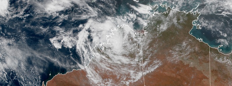
Featured image: Ex-Tropical Cyclone "Anika" at 03:20 UTC on February 28, 2022. Credit: JMA/Himawari-8, RAMMB/CIRA, TW
Tropical Cyclone "Anika" made landfall on the north Kimberley coast near Faraway Bay, Western Australia as a category 2 system on the Australian cyclone scale at 12:00 UTC (20:00 WST) on Saturday, February 26, 2022. Anika has been downgraded below tropical cyclone strength but is expected to strengthen again once it moves over waters off the west Kimberley early in the new week. A severe tropical cyclone impact to the east Pilbara or west Kimberley coast is forecast for late Wednesday or Thursday, March 2 or 3.
Heavy rainfall and flooding are forecast to continue in the northwestern Kimberley, including Broome, Derby, and Bidyadanga, with rainfall totals of 100 – 200 mm (4 – 8 inches) and isolated falls of 200 – 350 mm (8 – 14 inches) today and similar falls into early parts of this week, the Australian Bureau of Meteorology (BOM) said.
These falls are likely to cause some roads to become impassable and some communities may become isolated.
At 12:00 UTC on February 28, Anika was a tropical low with sustained winds near the center of 65 km/h (40 mph) and gusts to 95 km/h (60 mph), moving SW at 10 km/h (6 mph). Its center was located about 105 km (65 mph) SSW of Kuri Bay and 280 km (175 miles) NE of Broome.1
The system is expected to intensify further as it turns south over the open ocean on Wednesday.
A severe tropical cyclone impact to the east Pilbara or west Kimberley coast is forecast for late Wednesday or Thursday, March 2 or 3.

Ex-Tropical Cyclone "Anika" at 03:20 UTC on February 28, 2022. Image credit: JMA/Himawari-8, RAMMB/CIRA, TW

Gales with gusts to 100 km/h (60 mph) are expected along the Kimberley coast between Kuri Bay and Cape Leveque overnight. Gales may extend further west to Beagle Bay and Broome later Tuesday.
Destructive winds with gusts to 130 km/h (80 mph) are possible across the west coast of the Dampier Peninsula, including Cape Leveque and Beagle Bay overnight Tuesday night or Wednesday.
Gales with gusts to 100 km/h (60 mph) are expected to develop further west along the west Kimberley coast overnight Tuesday and on Wednesday, possibly extending as far west as De Grey later on Wednesday.
Destructive winds with gusts to 150 km/h (95 mph) are expected to develop between Broome and De Grey later Wednesday as the tropical cyclone nears the coast.
Heavy rainfall is forecast about the Kimberley overnight and on Tuesday as the system tracks near the Kimberley coast.
Heavy rainfall is then expected over the west Kimberley on Wednesday, extending to the eastern Pilbara overnight.
Tides will be higher than expected between Cape Leveque and De Grey on Wednesday.
References:
1 AUSTRALIAN BUREAU OF METEOROLOGY – TROPICAL CYCLONE WARNING CENTRE TROPICAL CYCLONE FORECAST TRACK MAP – Ex-Tropical Cyclone Anika Issued at 9:05 pm AWST Monday 28 February 2022. Refer to Tropical Cyclone Advice Number 34.
I'm a dedicated researcher, journalist, and editor at The Watchers. With over 20 years of experience in the media industry, I specialize in hard science news, focusing on extreme weather, seismic and volcanic activity, space weather, and astronomy, including near-Earth objects and planetary defense strategies. You can reach me at teo /at/ watchers.news.
Commenting rules and guidelines
We value the thoughts and opinions of our readers and welcome healthy discussions on our website. In order to maintain a respectful and positive community, we ask that all commenters follow these rules.